Articles are given in chronological order by date of publication. Those marked with an asterisk (*) indicate principal publications, mostly on sites and monuments that have been introduced to the scholarly world for the first time.
ABBREVIATIONS:
BAI: Bulletin of the Asia Institute (Bloomfield Hills, Michigan)
ISSN: 0890-4464
BSOAS: Bulletin of the School of Oriental and African Studies, University of London (Cambridge University Press)
ISSN: 0041-977X EISSN: 1474-0699
Available by subscription from Cambridge Journals Online
EI3: Encyclopaedia of Islam, Third Edition (E. J. Brill, Leiden-Boston)
ISSN: 1873-9830
Available on the Encyclopaedia of Islam website, http://referenceworks.brillonline.com/browse/encyclopaedia-of-islam-3
EIr: Encyclopaedia Iranica (Columbia University, New York)
ISSN 2330-4804
Available on the Encyclopaedia Iranica website, www.iranicaonline.org
JRAS: Journal of the Royal Asiatic Society of Great Britain and Ireland (Cambridge University Press)
ISSN: 1356-1863
Available by subscription from Cambridge Journals Online
MHJ: The Medieval History Journal, Journal of the Medieval History Society (Sage Publications, New Delhi - Thousand Oaks - London)
ISSN: 0971-9458
Available by subscription from Sage Online: http://mhj.sagepub.com
SAS: South Asian Studies, Annual of the British Association for South Asian Studies (formerly Society for South Asian Studies), the British Academy (Routledge, Taylor and Francis Group)
ISSN: 0266-6030
UDS: Urban Design Studies, Annual of the University of Greenwich Urban Design Unit (Araxus, London. www.araxus.org)
ISSN: 1358-3255
 The City of Turquoise, a preliminary report on the town of Hisar-i Firuza, M. and N. H. Shokoohy, Water and Architecture, AARP Environmental Design, II, Rome, 1985, pp. 82-9, 3 maps and architectural drawings, 5 photographs.
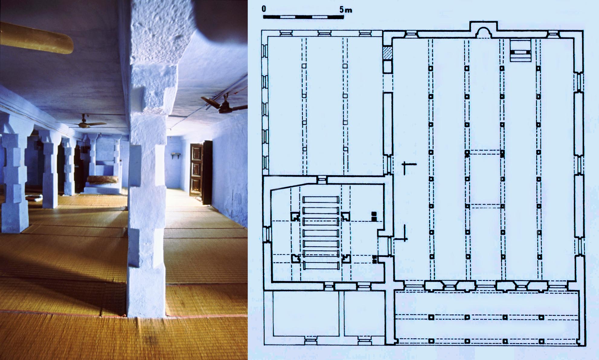
A brief introduction to the site of Hisar, unfamiliar at the time to many in the field, was published three years before the final report. The paper includes a plan of the old town of Hisar as well as a plan of the garden pavilion, known as Gujari Mahal and a plan and section of Lat ki Masjid. Other sites of the district of Hisar are not discussed. For the full report see: Hisar-i Firuza, Sultanate and Early Mughal Architecture in the District of Hisar, India.
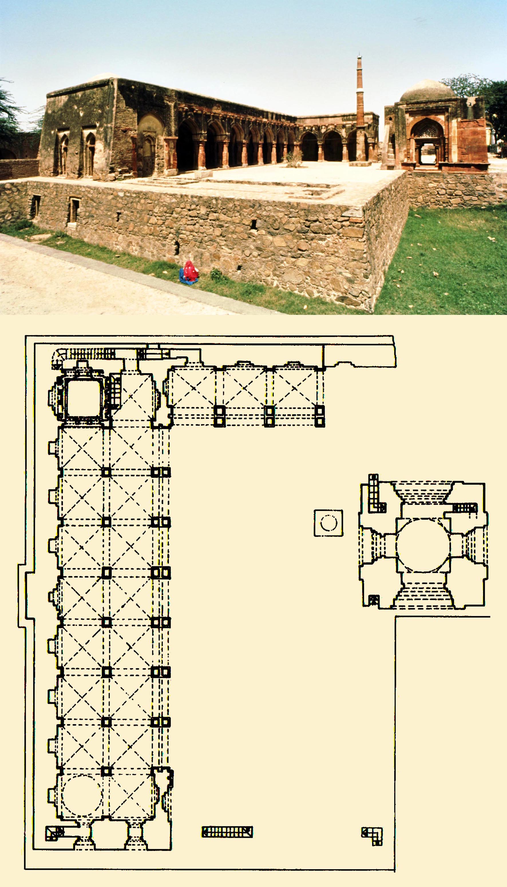
The royal mosque of Hisar built within the palace complex and known as Lat ki Masjid after the column (lat) set up by Firuz Shah in its courtyard. The lower register of the column is part of an ancient Ashokan pillar, the other part of which may be that in Fatehabad, again erected by Firuz Shah and inscribed with the early history of the Tughluq dynasty up to the beginning of his reign.
* The Architecture of Baha al-din Tughrul in the region of Bayana, Rajasthan M. and N. H. Shokoohy, Muqarnas, IV, 1987, pp. 114-32, figs 1-27 (9 architectural drawings, 20 photographs).
ISBN: 978-8-178240-10-7 ISSN: 0921-0326
Malik Baha al-din Tughrul was of handsome disposition, very just and kind to the needy or strangers. He was a slave of long standing of the victorious sultan Muizz al-din (Muhammad ibn Sam) who had brought him up and given him a good education. The fortress of Tahangar was in the territory of Bhayana ... When the sultan conquered it, he gave it to Baha al-din Tughrul who made that territory prosperous. Merchants and men of distinction from different parts of Hindustan and Khurasan joined him and he gave all of them houses and resources which were to be their own property, and for this reason they settled near him. As he and his army found the fort of Tahangar unsuitable he built the town of Sultankut in the territory of Bhayana, and here he made his abode... There was a speck of the dust of vexation between Malik Baha al-din Tughrul and Sultan Qutb al-din. Malik Baha al-din Tughrul was extremely benevolent and in the region of Bhayana numerous beneficial monuments of his have remained. He died and was received into the mercy of the Lord.
Minhaj-i Siraj, the historian of the early sultanate of Delhi, so describes the founder of Bayana. A rival of Qutb al-din Aibak (whose authority he did not accept) Baha al-din went as far as declaring himself sultan in an inscription in his mosque, the Chaurasi Khamba at Kaman, but died early during his governorship of Bayana so a conflict between him and Qutb al-din was averted. Two of Baha al-dins mosques, the Chaurasi Khamba and in Bayana the Ukha Mandir Masjid (it has been converted to a temple) are amongst the earliest sultanate buildings in India.
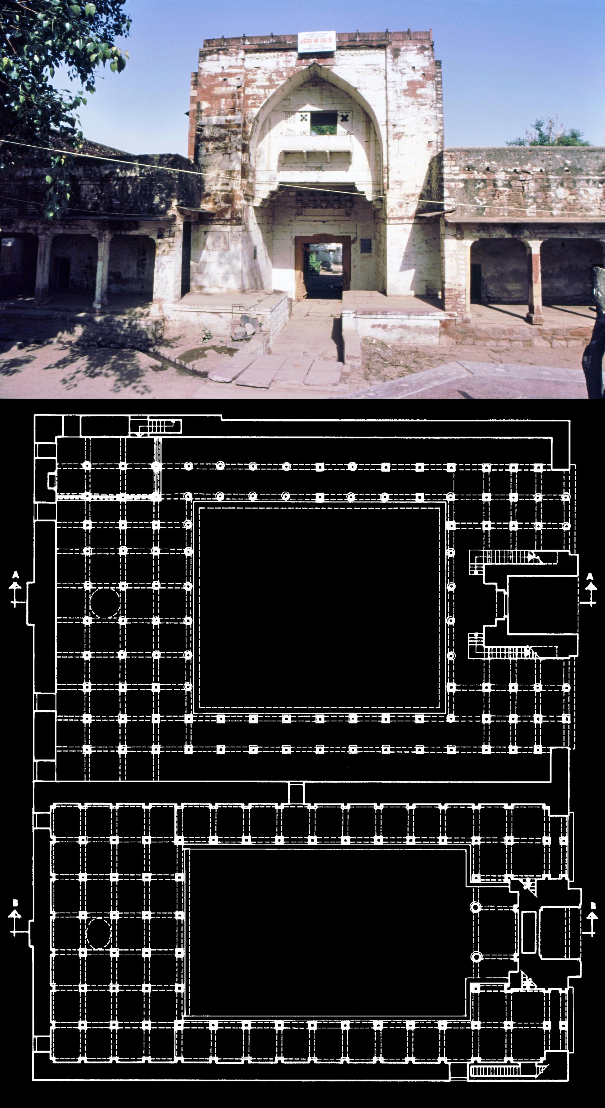
Ukha Mandir Mosque, one of the oldest sultanate structures in
India dating from the end of the twelfth or very first years of
the thirteenth century. The arch of the portal is not a true arch,
but what is called a corbelled arch with stones laid horizontally.
In plan the structure with the smaller courtyard is an extension
of AD 1320-21 by Malik Kafur (Mubarak Shah Khaljis governor)
and known as Ukha Masjid.
Ukha Masjid, praised by the fourteenth century Moroccan traveller Ibn Battuta.
In later dates an extension, now known as Ukha Masjid was built at one side of the Ukha Mandir mosque at the time of Mubarak Shah Khalji in AH 720 (AD 1320-21). The mosque and its extension, when still very new, was visited by Ibn Battuta who notes: Bayana is a great city and has fine buildings and attractive bazaars, and its Jami is one of the finest mosques, with walls and ceilings all of stone.
 The mosques of Baha al-din, built out of temple spoil, represent the distinctive features of the earliest sultanate mosques, including multiple prayer niches (mihrabs) and a dedicated royal chamber known as muluk khana or shah nishin, at the north side of the prayer hall. These features became characteristics of the architecture of the sultanate mosques, a trend that continued for several centuries.
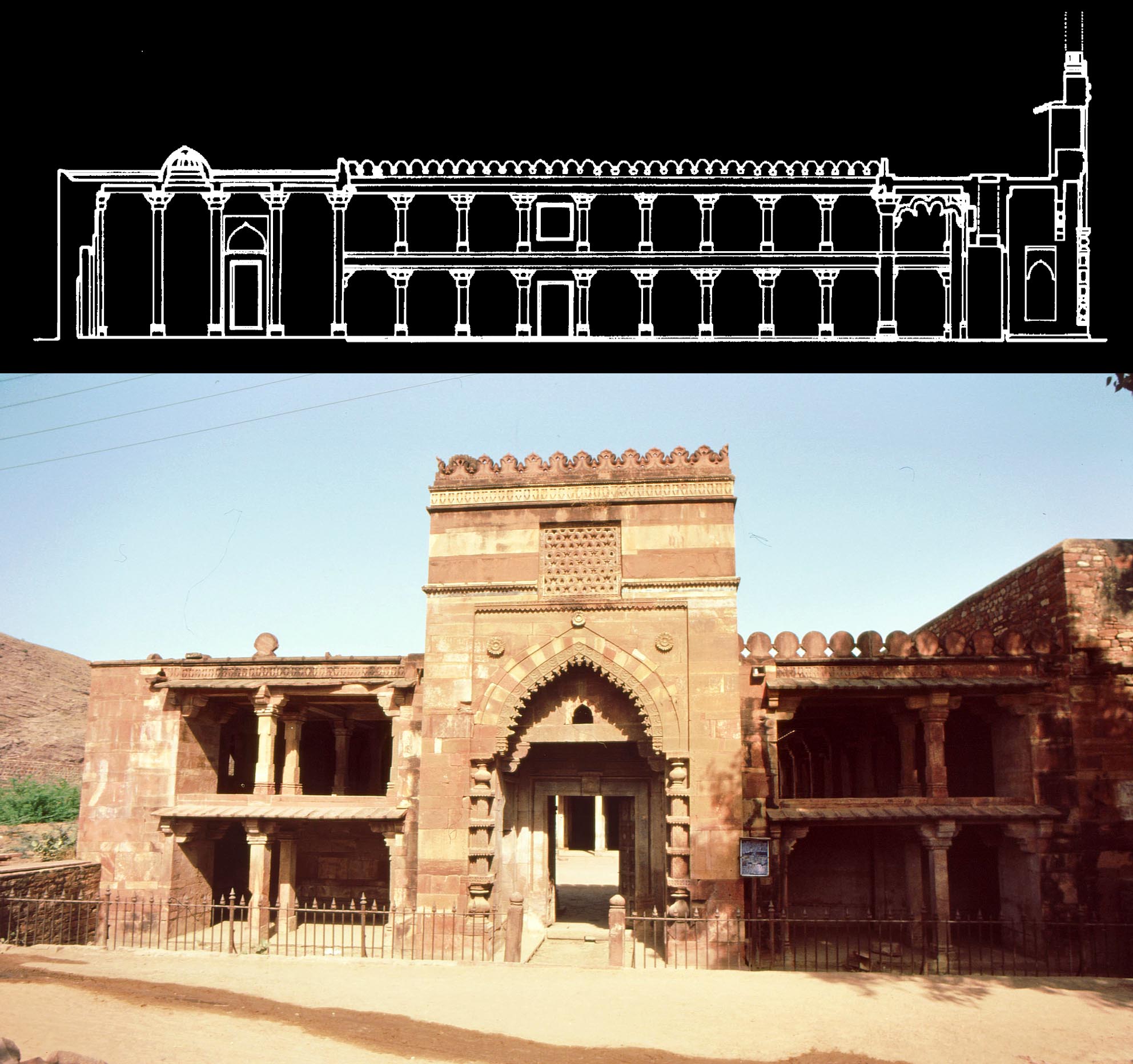
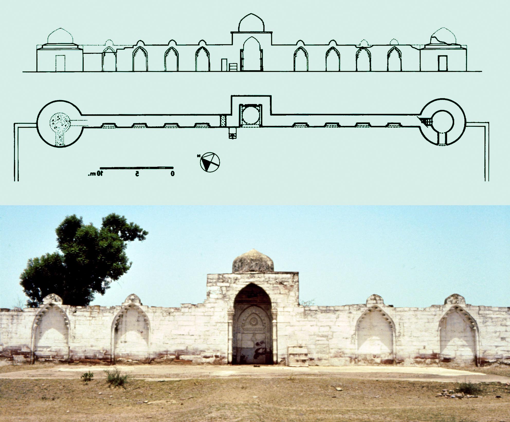
As well as the mosques, the prayer wall (idgah) of Bayana, likely to date from the time of Baha al-din Tughrul, making it the oldest specimen of its kind in India, is also discussed.
The ʽidgah or namazgah of Bayana has, instead of
a simple mihrab (prayer niche), a small chamber in
the centre. This feature, together with the corbelled
instead of true arches, indicates its early date.
 Muslim architecture in Gujarat prior to the Islamic conquest, M. Shokoohy, Marg, XXXIX, iv, 1988, pp. 75-78, figs 1-9 (1 architectural drawing, 8 photographs).
ISSN: 0972-1444
Gujarat was the only region in India to have an established tradition of Muslim architecture before the Islamic conquest. To introduce the material in the book Bhadresvar, the oldest Islamic monuments in India, the shrine of Ibrahim and the two mosques: the Solahkhambi and the Chhoti Masjid in Bhadresvar (Bhadreshwar) as well as the mosque of Abul-Qasim b. ʽAli al-Idhaji (or al-Iraji) in Junagadh are briefly considered and the stylistic development of the architecture of the Muslim trading communities on the Gujarat coasts during the twelfth and thirteenth century is discussed.
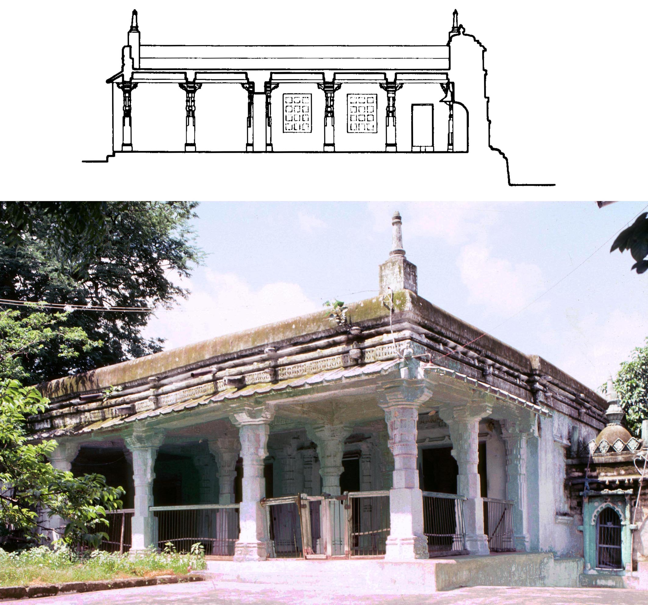
The mosque at Junagadh built in AD 1286-7 by Abul Qasim b. ʽAli, the head of the merchants and shipmasters of the town. The grand portico in front of the prayer hall is a hallmark of the buildings of the Muslim maritime traders on the Indian littoral.
* Architecture of the Sultanate of Ma'bar in Madura and other Muslim monuments in South India, M. Shokoohy, JRAS, 1991, pp. 31-92, figs 1-18, pls 1-16 (32 monochrome photographs).
 The obscure history of the short-lived fourteenth-century Sultanate of Ma`bar and the monuments related to it in present Tamil Nadu, presented first in a lecture to the Royal Asiatic Society in 1990, was the first report (extended for this paper) of the wide-ranging project of surveying the then almost unknown Muslim architecture of the South India littoral, culminating in the publication of Muslim Architecture of South India.
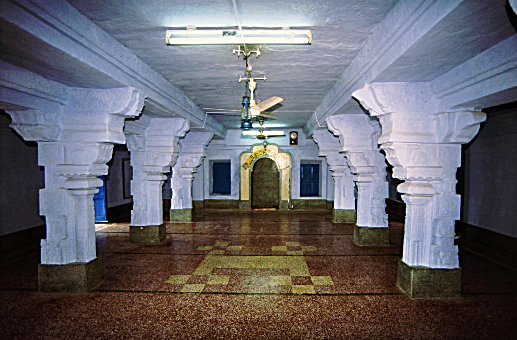
 The tomb of Sultan ʽAla al-din Udauji in Madura where Sultan Shams al-din `Adil Shah is also buried was brought to the attention of scholars, and on the same site the tombs of Sayyid Husain Quddusullah (belived to be a vezier of `Ala al-din) and Shaikh Muhammad `Abdullah Bara Mastan Sada Pir were also discussed. These edifices are just outside old Madura, where the Muslim graveyard must have been. In the old town, and not far from the grand Sri Minakshi temple, the historic mosque of Qadi Taj al-din was also examined. Far away from Madura in Tiruparangundram, the site of the final episode of the sultanate of Ma`bar, the tomb of Sikanar Shah (the last sultan, killed in a battle with the Vijayanagar forces) was also studied.
The square domed chamber surrounded by a colonnade
two bays deep houses the tombs of ʽAla al-din Udauji
(c. AD 1338-9) and Shams al-din ʽAdil Shah (c. 1356-72).
The form is alien in South India, but resembles the tomb
chambers of Gujarat. In the garden and in front of the
tomb of ʽAla al-din and Shams al-din stands the small
chatri tomb of Sayyid Husain Quddusullah.
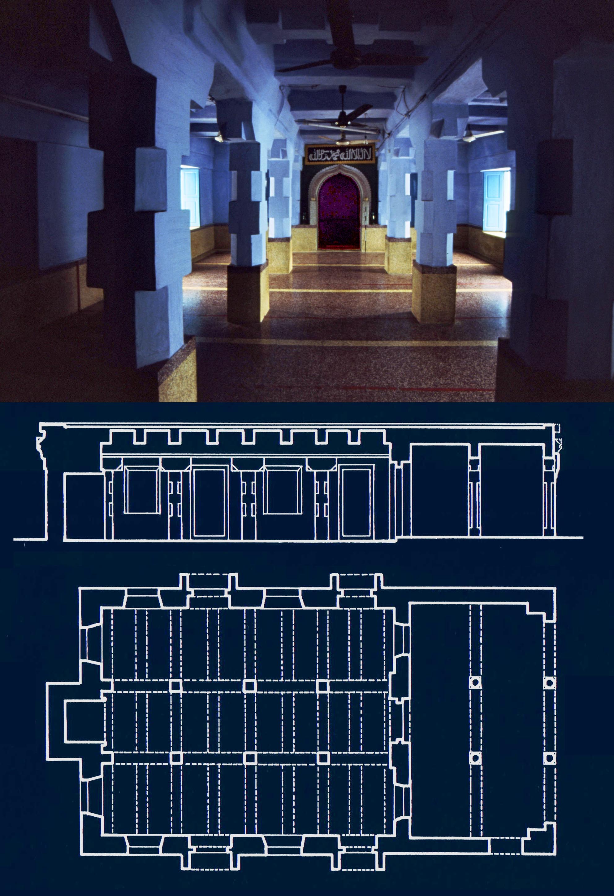
The mosque next to the tomb of ʽAla al-din and Shams al-din, with a colonnaded portico almost as large as the prayer hall, characteristic of the mosques of the maritime merchants. An inscription of Shams al-din ʽAdil Shah in the compound confirms the existence of such traders in his territory.
Brief notes of the monuments of Calicut with some sketch drawings are also given (superseded by detailed survey drawings made in later fieldwork). For a full account of the sites discussed see the book: Muslim Architecture of South India.
History and Architecture of Kirtipur, Nepal, M. and N. H. Shokoohy, South Asia Library Group Newsletter, XXXIX, 1992, pp. 25-9, 2 figs.
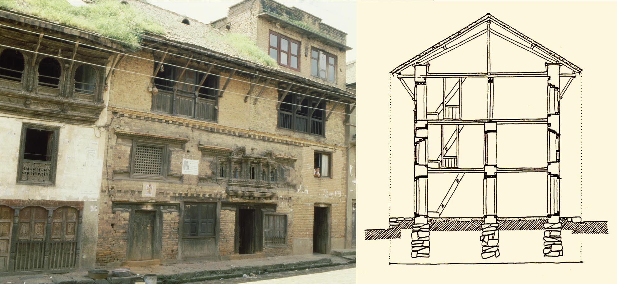
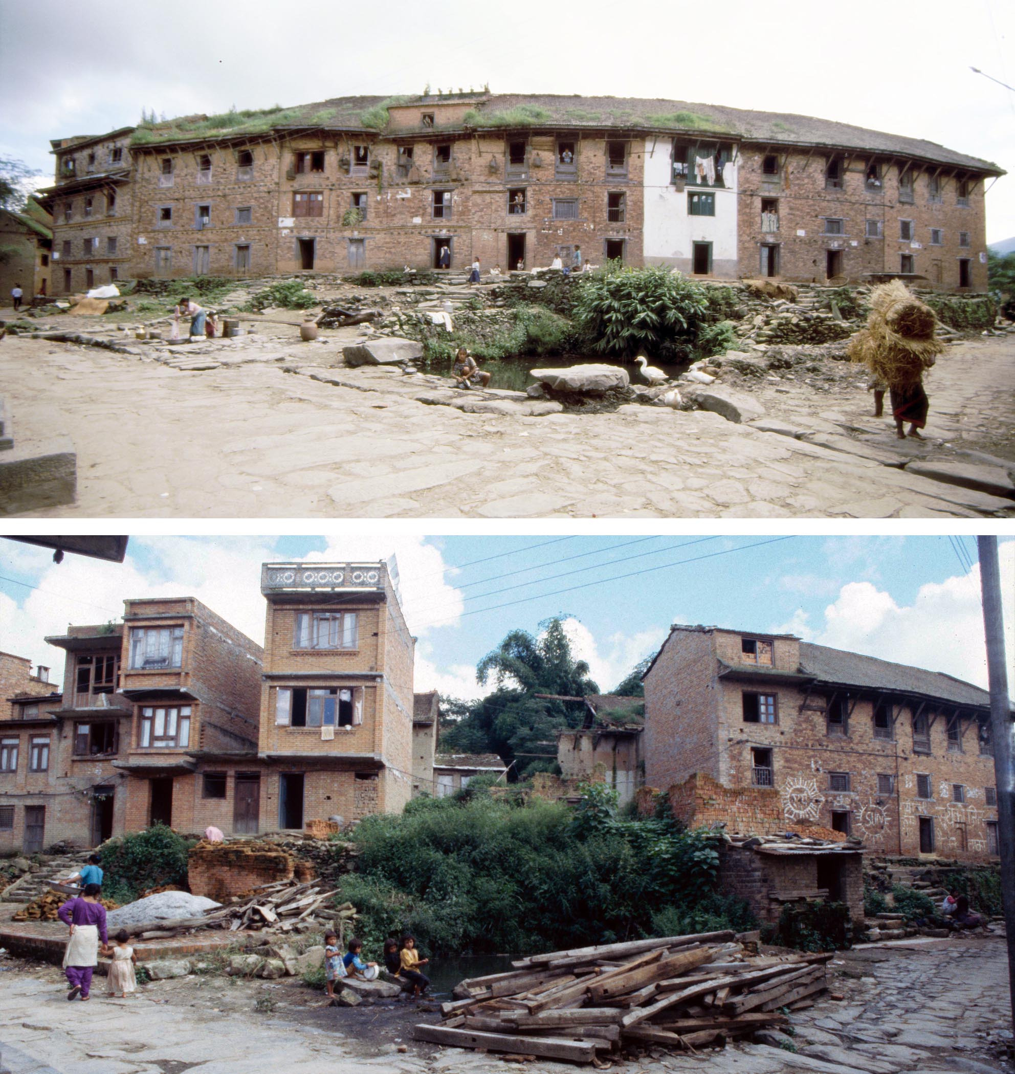
By the 1990s the art, architecture and social life of Nepals major urban centres and some distant locations had become well known through books, films and its popularity as a travel destination. Kirtipur, however, in spite of its historic importance as a former Newar capital and its proximity to Kathmandu had remained out of the picture. In an illustrated talk in 1992 at the Royal Asiatic Society the Shokoohys brought the town to the attention of the members of the South Asia Library Group. Mehrdad Shokoohy discussed the history, caste system and social structure of the town reflected in the morphology of the town plan, and Natalie Shokoohy introduced the architectural characteristics of Kirtipur. The paper includes an account of the hierarchical organisation of houses as the sacred territory of the family with the ground floor as a transitional zone which outsiders can enter, progressing to the first floor, representing the world of people, where the family lives and people of acceptable caste may also enter, to the second floor, symbolising the celestial regions and housing the more private family accommodation, and finally the attic, the most sacred part of the house where food is prepared and only the close family gather.
 Religion plays a dominant role in the urban fabric with Buddhists and Hindus living in harmony, but in distinct quarters. Although this tradition is gradually eroding, the Hindu temples such as the Bagh Bhairav and Uma Mheshvara are in the historic Hindu area while the Budhhist shrines, monasteries and the impressive Chilancho Stupa are surrounded by clusters of dwellings inhabited by Buddhists. The paper was an early report of the project of studying multiple aspects of the town, its people, urban form, religious and domestic architecture, resulting on the publication of Kirtipur: an Urban Community in Nepal two years later and the Street Shrines of Kirtipur in 2014.
A traditional house in Layaku, opposite the site of the old palace, and a section through a typical Newar house, with the platform under the eaves and the ground floor being an interface between the householder and customers or passers-by, while the upper floors become progressively more private with the kitchen in the attic the most secluded area.
* Architecture of the Muslim Port of Qa'il on the Coromandel Coast, South India, Part One, History and the 14th-15th Century Monuments, M. Shokoohy, SAS, vol. IX, 1993, pp. 137-166, figs. 1-15 (2 maps and 27 architectural drawings), pls 1-16
 The first interim report on the historic port of Qaʽil (now Kayalpatnam) in Tamil Nadu embarked on an account of its extensive architectural heritage. The work was part of a wider project started in 1988 and culminating in 2003 with the publication of Muslim Architecture of South India, with the aim of recording the architecture of the Muslim maritime settlers. Four seasons of fieldwork were carried out in 1988, 1990, 1994 and 1996.
The Jamiʽ al-saghir, the smaller congregational mosque
of Kayalpatnam, which although not dated must belong
to at least the fourteenth century on account of the dated
tombstones in the chamber attached to the prayer hall.
Ahmad Nainar, a small but pleasant building featuring the characteristics of a Muslim trading community mosque including a fairly large portico in front of the prayer hall.
The history of the port, visited among others by Marco Polo, is given; he noted: "Cail is a great and noble city, and belongs to Ashar, the eldest of the five brother kings. It is at this city that all the ships touch that come from the west, as from Hormos and from Kis and from Aden and all Arabia, laden with horses and with other things for sale, and this brings a great concourse of people from the country round about, and so there is great business done in this city of Cail".
Decorative details on the parapet of the roof of
the Ahmad Nainar Mosque relate to the features
known as vajramastaka in early Buddhist and
Hindu temples. Similar motifs also appear around
the roof of the Greater Jamiʽ, which bears a date
of AH 737 (AD 1336-7).
A map of the region as well as a town plan of Kayalpatnam shows the location of major monuments. The historic remains are discussed beginning with the two Jami` mosques, the greater bearing an inscription recording its construction in AH 737/AD 1336-7, and the smaller, possibly even earlier. Other earlier buildings described include the mosques of Ahmad Nainar, the Qadiriya, and Ahmad Makhdum Wali (d. 539/1144-5), all of which are entirely roofed, a characteristic of South Indian mosques -- which unlike those of North India, do not have courtyards in front of a prayer hall. Numerous drawings of plans, sections and details of the special features set out the salient characteristics.
 * Architecture of the Muslim Port of Qa'il on the Coromandel Coast, South India, Part Two, the 16th-19th Century Monuments M. Shokoohy, SAS, vol. X, 1994, pp. 162-178, figs 1-8 (1 map, 20 architectural drawings), pls. 1-14.
Rettaikulampalli, one of the finest small mosques of Kayalpatnam, the plan of which presents some innovations, including the wide central aisle, but the traditional portico in front of the prayer hall is maintained.
The second interim report on Kayalpatnam the historic port of Qa`il is concerned with the later monuments of the town, discussing the development in the design of mosque plans as well as the more elaborate carvings of the architectural elements. The mosques of Rettaikulampalli, Marakkayarpalli, Kadayapalli and Mahalara are described, supported by survey drawings as well as the shrines, including Koshmurai Appa and the tombs of Shaikh Sulaiman, and Shaikh Sam Shahab al-Din Wali'ullah.
 The interior of Rettaikulampalli displays finely decorated monolithic
columns, inspired by the late sixteenth to seventeenth century Hindu
architecture of Tamil Nadu. Similar columns appear in the renovated
centre of the prayer hall of the Greater Jamiʽ.
These tombs, while built entirely with stone, have hipped roofs, complete with three finials, imitating the form of timber roofs in Malabar (the west coast of India), indicating that timber structures with hipped roofs must have been commonplace in the past. Existing examples can still be found in the Kattupalli and in some of the nineteenth and early twentieth century extensions to the earlier mosques. For the final report of the whole area see Muslim Architecture of South India.
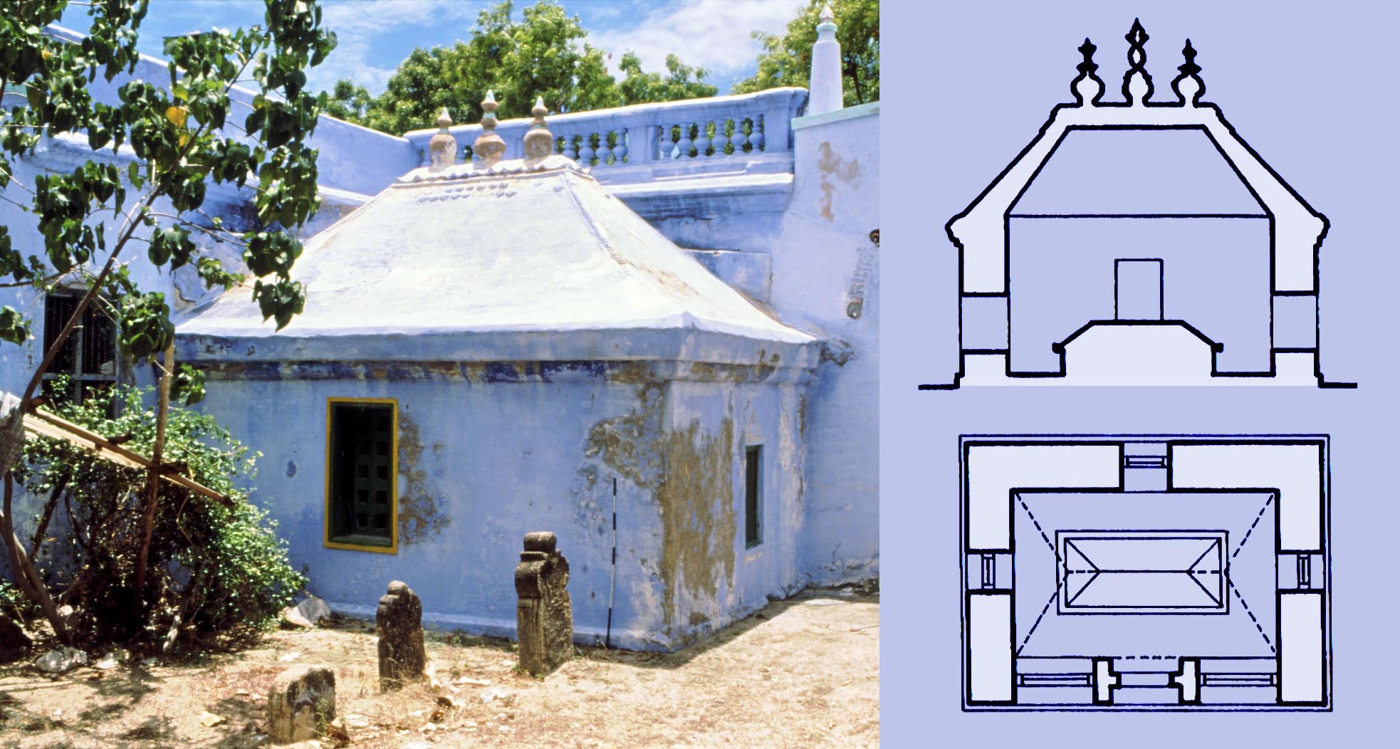
The tomb of Shaikh Sulaiman (AD 1591-1669) built of stone, but in the style of a wooden structure with a hipped roof and three finials, showing that wooden buildings in the South and South-East Asian style would have been more common in the region then they are now.
* Tughluqabad, the earliest surviving town of the Delhi Sultanate M. and N. H. Shokoohy, BSOAS, vol. LVII, 1994, pp. 516-550, figs 1-14 (1 town plan and 24 architectural drawings) pls. 1-16 (32 photographs).
One day he [Ghiyath al-din Tugluq] was accompanying Sultan
Qutb al-din [Mubarak Shah] and pointed to the site and said
O Lord of the World how good it would be if a city could be
built there. The sultan replied sharply: build it when you are
the sultan. As God willed it he did become the sultan, built the
city and named it after himself'.
The fourteenth-century traveller, Ibn Battuta.
Many years ago a colleague commented to the Shokoohys that their work was on such out of the way places that it was hard to dispute, as hardly anyone else in the field had seen the locations, let alone written on them, and why did they not look into somewhere more familiar? The challenge was irresistible. Tughluqabad is nine miles to the south-east of the capital, Delhi, and its towering fortifications dominate the landscape. The project to survey it was launched in 1984.
This first report took the neglected site, where the early-fourteenth century capital remains in a time capsule after its abandonment, and gives a town plan based on an aerial survey of 1946, before modern accretions. The public palaces and other structures in the fort are discussed, and sketches of the ruins of the well-known jahan nama, a pavilion over the private palaces in the Citadel are given. In the town the paper considers the ruins of a house and the substantial Jami`, the congregational mosque, with reconstruction drawings suggesting its original form. Many of the drawings, including the town plan, were work in progress and are superseded by more detailed and accurate drawings as the project continued, with second and third interim reports in BSOAS, an article in UDS, V, on the planning of Tughluqabad and its divergence from traditional Hindu urban forms, and in 2007 the final report as a monograph: Tughluqabad, a paradigm for Indo-Islamic urban planning and its architectural components.
.jpg?791) * Sasanian royal emblems and their re-emergence in the fourteenth-century Deccan M. Shokoohy, Muqarnas, XI, 1994, pp. 65-78, figs. 1-21 (3 engravings, 7 drawings, 11 photographs).
* Sasanian royal emblems and their re-emergence in the fourteenth-century Deccan M. Shokoohy, Muqarnas, XI, 1994, pp. 65-78, figs. 1-21 (3 engravings, 7 drawings, 11 photographs).
ISSN: 0921-0326
ISBN: 978-9-004259-31-7
The necropolis of the early Bahmani sultans at Gulbarga
displaying variations of a device composed of a pair of
wings below a crescent moon, in some cases encircling
a disc which occasionally bears the word Allah.
The Bahmani dynasty of the fourteenth century Deccan in central India claimed descent from the pre-Islamic Sasanian dynasty of Iran. The Bahmanis decorated the crowns of the arches of their monuments with a curious device, which varies in detail but has a crescent or disc flanked by open wings, closely resembling the emblems on the crowns of the Sasanian emperors. The crest appears on the buildings of several early Bahmani sultans, who perceived that their claim to royal ancestry would reinforce their legitimacy to the throne, but as they consolidated their power, the device became transfigured gradually to a simple decorative feature, and during the following dynasty the `Adil Shahis evolved as two wings or two large triangular forms filling up the space above the arch.
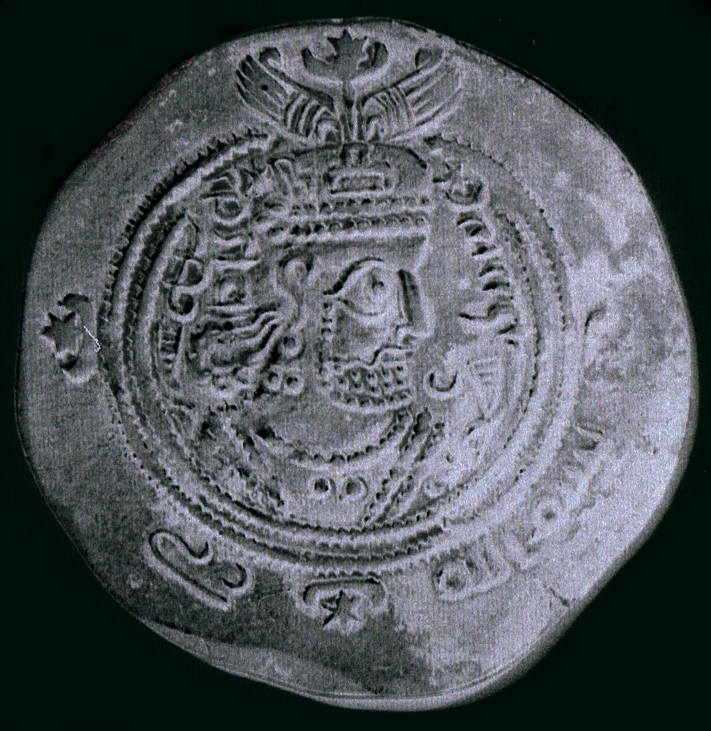 Investigation of the roots of the form from ancient Iran to the Sasanian crowns prompts the argument that that although the device appears on the crowns of Sasanian emperors on all their coins, it is unlikely that the Bahmanis would have taken their emblem from coinage, as if they had seen the coins found in large numbers even today they would not relate the device to the arches of buildings. Another thread is, therefore, investigated, presenting historic and archaeological evidence of such a device appearing over the arches of the Sasanian buildings and even on some early Muslim structures.
A coin of the Sasanian Emperor Khusraw II showing the emperor wearing a crown topped with a pair of wings, the crescent moon and a star. On the crown of earlier Sasanian emperors a disc or globe is presented instead of the star.
 In the fourteenth century Sasanain ruins would have been commonplace in Iran and Central Asia, the homeland of the Bahmani family, and it would have been from these buildings that they adopted their concept, perhaps unaware of the symbolic meaning of each of the Zoroastian features: the wings representing God (Ahura Mazda), and the crescent and disc the divine beings Anahita and Mithra.
Above: a version of the Bahmani motif over
the arch of a shop in the bazaar of the fort
of Gulbarga, and below: an old photograph of
a Sasanian ossuary, representing an arched
portal with a device similar to that on the crown
of the Sasanian emperors.
Kirtipur: Cultural traditions under siege, M. Shokoohy, UDS, I, 1995, pp. 125-132, figs. 12.1-12.7.
ISBN: 978-1-870606-04-2
ISSN: 1358-3255
 The nature of the town of Kirtipur, and the relationship of the population with urban space was the primary focus of the project initiated at the University of Greenwich in 1985 resulting in the publication of Kirtipur, An Urban Community in Nepal, and continuing until 2014 with the book Street Shrines of Kirtipur.
In this early report on the Greenwich project, an explanation is given of how the focal points of the neighbourhoods, the Buddhist and Hindu temples and shrines, which share the architectural traditions of other Kathmandu Valley towns, define the neighbourhoods and how the temples and shrines are incorporated in the many and varied processional routes for religious festivals and joyous occasions as well as the particular routes for funerals through the town.
Deo Dhoka Tole with its traditional dwellings still standing in 1986, but many collapsed some years later, probably undermined by an earthquake in 1988. They were reconstructed in later years with no reference to the traditional architecture of the town.
 The spiritual aspect of life is not confined to formal worship and dominates all aspects of the daily life of the townspeople. The sacred territory of the family is the house, and its arrangement is understood in terms of a complex symbolism, with the house taking its roots in the underground world, rising up to the earth, where people live, and pointing towards the celestial regions. The construction materials and other elements too have their own symbolism, and spiritual considerations also regulate the practical use of a dwelling, according to a vertical hierarchy. The importance attached to these considerations and to living in the ancestral home have an essential role in the way the houses are used and extended, and the density of housing. However, the traditions are fluid, and the impact of modern ways of life and the proximity of the capital, Kathmandu are challenging the old norms. Another report Social effects of land use changes in Kirtipur, Nepal (UDS, III, 1997) considers our follow-up study of the physical, morphological and social changes which are taking place rapidly in Kirtipur.
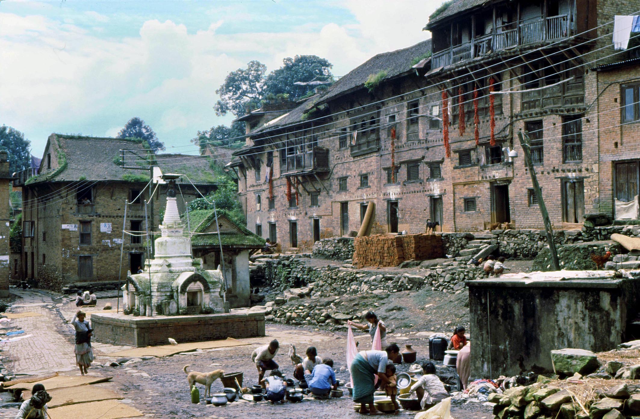
The toles, or clusters of related houses of Kirtipur provide the space
for families of the neighbourhood to interact, while getting on with
everyday occupations: washing and drying laundry, bathing, or
processing the harvest. The street shrines in the toles are a focus
for daily worship as well as marking the routes of the many religious
processions. This view of Tanini Tole taken in 1986 shows how the
houses still preserved their traditional form, but in the following
decade many were altered with additions and reconstructions.
Epitaphs of Kayalpatnam, South India, M. Shokoohy, SAS, vol. XI, 1995, pp. 121-128, figs 1-7.
 Kayalpatnam means Kayal city", but the town was not recognised by scholars as the famous ancient Qa'il, visited by many early travellers. Influenced by the views of Robert Caldwell, Coadjutor Bishop of Madras, and regarded an authority on South Indian history early in the twentieth century, even Henry Yule, while noting in his edition of Marco Polo that "Kayalpatnam must in all probability be the place", still published Caldwell's dismissive comment: "There are no relics of ancient greatness in Kayalpattanam and no traditions of foreign trade, and it is admitted by its inhabitants to be a place of recent origin, which came to existence after the abandonment of the true Kayal. They state also that the name of Kayalpattanam has only recently been given to it, as a reminiscence of the older city.
This view confused later reports, even the Imperial Gazetteer of India where two entries appear, under Kayal and Kayalpatnam as well as that of Sayyid Yusuf Kamal Bukhari, who published two Muslim epitaphs of Kayalpatnam, noting the town as a small port in the Tinnevelly District, but not to be confused with the historic Qa'il.
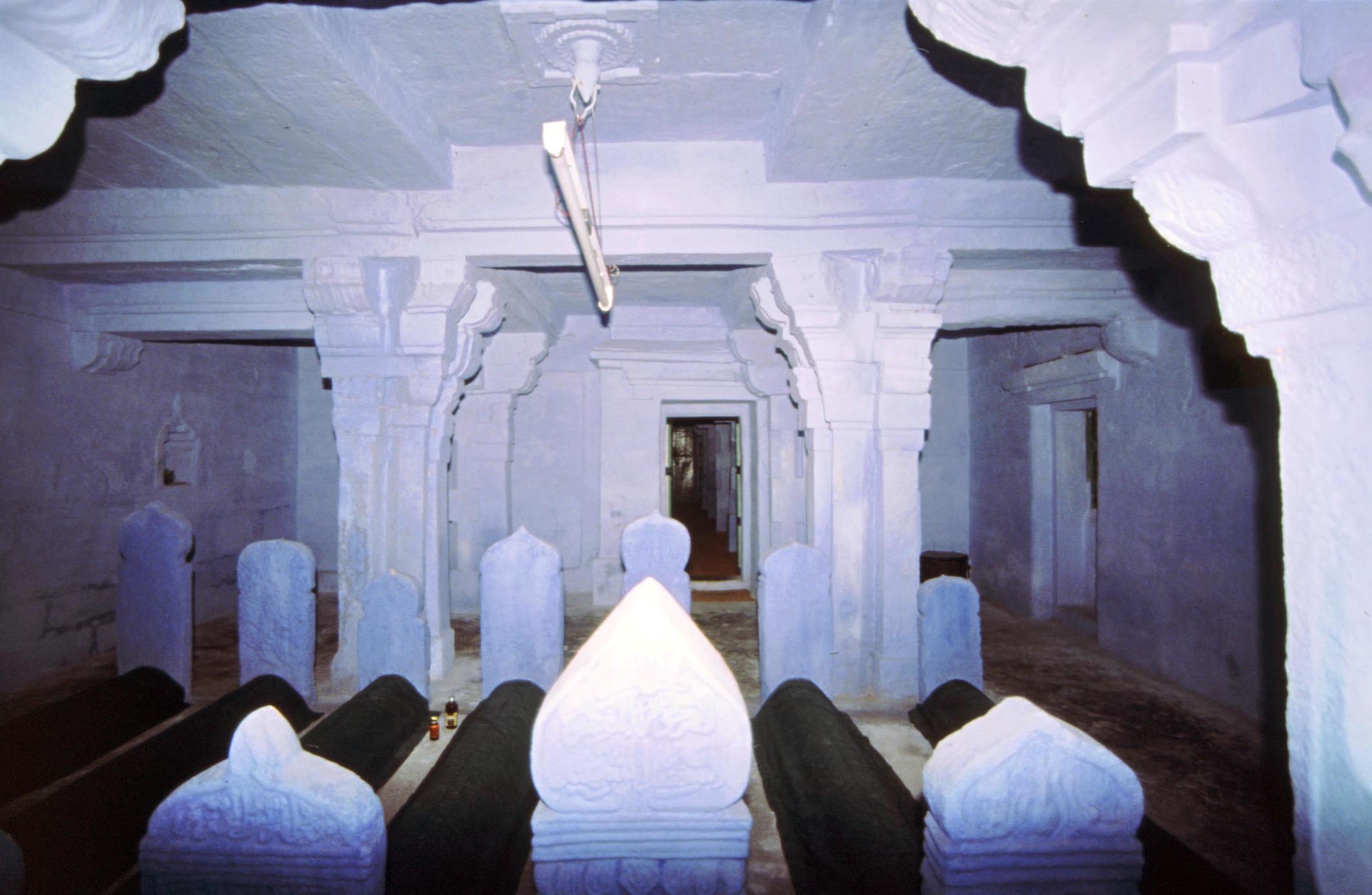
Tombs of personages who lived in the late fourteenth and early fifteenth century, in
the tomb chamber attached to the smaller congregational mosque (Jamiʽ al-saghir).
 Caldwells view, in spite of claiming that he had spent some time in Kayalpatnam, ignored the townspeoples belief that their town is the same as Qa'il and their veneration of the shrines of their Sufi saints, some of whom are believed to have settled there as early as the twelfth century. Moreover, if Caldwell had examined Kayalpatnam itself he could not have missed the numerous old tombstones in the graveyards attached to the mosques, inescapable to even an untrained eye.
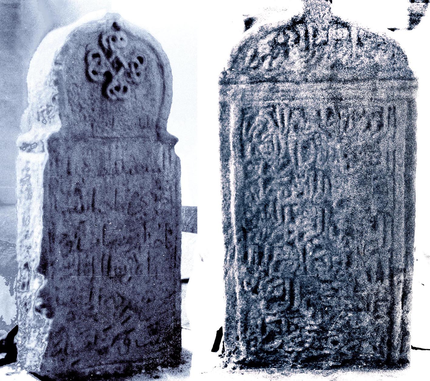
To set the record straight the paper examines some of the fifteenth and sixteenth century epitaphs, giving their texts and discussing the history of the named personages. These epitaphs, together with an inscription in the larger of the two congregational mosques giving the date of the building as AH 737/AD 1336-7 and also the late fourteenth and early fifteenth-century epitaphs in a shrine known as the Seven Martyrs are indisputable evidence of the continuous life of the town and re-establish Kayalpatnam and its monuments in their rightful place in history. A comprehensive account of the city is given in Muslim Architecture of South India.
Two epitaphs in the Jamiʽ al-saghir tomb chamber: (left) dated 9 Dhil-hijja
806 (18 June 1404) and (right) 4 Shawwal 811 (20 February 1409).
 Entries in The Grove Dictionary of Art, (ed. Jane Shoaf Turner) 34 vols, Macmillan, London-New York, 1996.
ISBN: 978-1-884446-00-9 Available by subscription from www.oxfordartonline.com
The entries on Indo-Islamic architecture, and on some major towns of Muslim origin in India for the Grove Dictionary of Art are written by the Shokoohys. PDFs of these papers are not currently available.
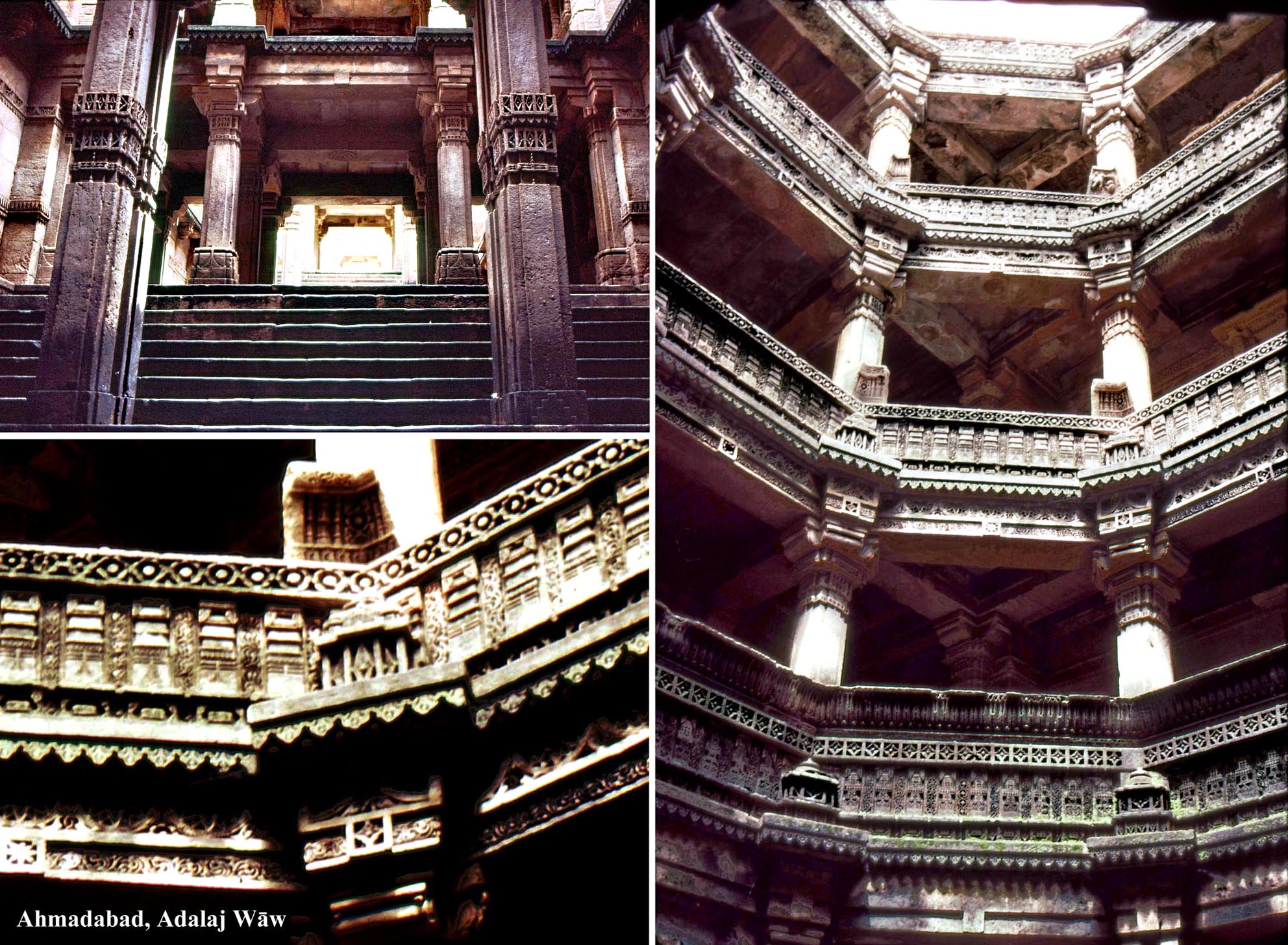
The marriage between Muslim architecture and traditional Hindu and Jain building methods is best displayed in Gujarat. The fifteenth-century Bai Harir Wav (step-well and reservoir) is not only built using traditional structural methods, but has carvings based on old Indian motifs.
.jpg?12 "05-12_Mandu,_Hindola_Mahal_(audience_hall)") Entries written jointly by M & N. H. Shokoohy:
Entries written jointly by M & N. H. Shokoohy:
Indian Subcontinent, 11th-16th century, (b) North India (sultanates), vol. XV, pp. 338-346;
Indian Subcontinent, 11th-16th century, (c) West (Gujarat and Nagaur), vol. XV, pp. 346-351;
Indian Subcontinent, 11th-16th century, (d) East (Bengal), vol. XV, pp. 351-353;
Indian Subcontinent, 11th-16th century, (e) Central (Malwa), vol. XV, pp. 353-355;
The short-lived sultanate of Malwa, established after the fall of the Tughluq dynasty, took the
traditions of Delhi architecture and refined them further by employing inlaid marble. The audience
hall known as Hindola Mahal is exceptional among sultanate halls in having survived intact. It
follows the principles of Tughluq audience halls, but, unlike that of Tughluqabad, is free-standing.
The battered walls also follow Tughluq forms.
_court.jpg?12) The following entries by M. Shokoohy:
The following entries by M. Shokoohy:
Indian Subcontinent, 6th-11th century, (b) West (Bhadresvar), vol. XV, pp. 308-9;
Indian Subcontinent, 11th-16th century, (f) South (Deccan), vol. XV, pp. 355-358 (Kerala and Tamil Nadu) 355-359;
Chanderi, vol. VI, p. 444;
Mandu, vol. XX, pp. 250-251.
Chanderi, a border town of the sultanate of Malwa was eventually annexed to the Mughal empire by Akbar and many buildings of the town, including private houses, some on a grand scale, date from the Mughal period. Kamal Singhs house is a good example, retaining its original features, including the public court (below) and private court (above).
.jpg?12) The following entries by N. H. Shokoohy:
The following entries by N. H. Shokoohy:
Indian Subcontinent, 6th-11th century, (ii) Indo-Islamic, vol. 15, 306-7, (a)
North-West (Sind), vol. 15, 307;
Indian Subcontinent, 11th-16th century, (ii) Indo-Islamic, vol. 15, 336-7, (a)
North-West (Multan - East Punjab), vol. 15, 337-8;
Jaunpur, vol. 17, 451
Multan, vol. 22, 279
The Sharqi kingdom of Jaunpur came to a violent end when the Delhi Sultan Sikandar Lodi took
over the town and destroyed it except for a few mosques. Nevertheless, the surviving monuments
demonstrate the development of a local architecture relating to both Delhi and Bengal. The Atala
Masjid (1377-1404 AD) built incorporating temple spoil, but with a massive central screen three
times higher than the colonnaded prayer hall, marks a new style adopted in later buildings.
 * Social effects of land use changes in Kirtipur, Nepal M. and N. H. Shokoohy and Uttam Sagar Shrestha, UDS, III, 1997, pp. 51-74, figs. 3.13.24.
ISBN: 978-1-870606-05-9
ISSN: 1358-3255
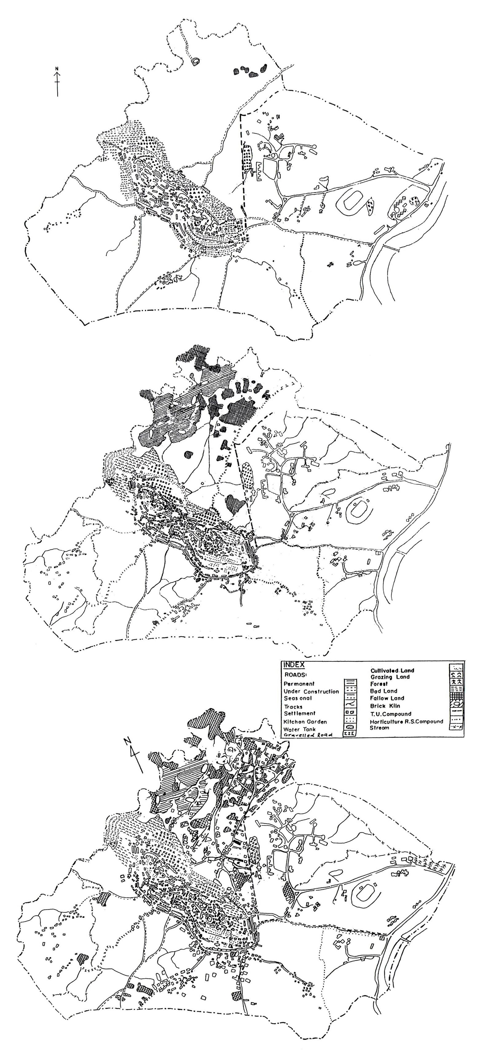
The rapid changes in society in Kirtipur linked to alterations in land use in the 1990s are not discussed in other books and papers concerning the town. The relatively static medieval type of society that existed in Nepal until the 1950s had been challenged when a motorable road link from India made modern facilities available to the country. Over the years, changes in local government along with the development of the capital and the nearby Tribhuvan University in the late 1970s altered the balance between the cultivated and built-up areas of Kirtipur, then a small agricultural town close to the capital. The changes are documented, explaining how the town, once strategically located on a trade route, had retained, in spite of invasion, earthquakes, and neglect, much of its mediaeval layout and traditional way of life. The temples, houses and kitchen gardens were clustered mainly on an outcrop of rock within the walls, further protected by a band of woodland, maximising the defensive potential of the site, and reserving the surrounding fertile land for agriculture. The study of land use in recent decades reveals a gradual densification and expansion of the historic core, a reduction in the area of kitchen gardens and woodland, and much new housing along roads and tracks to the town.
The drastic reduction in cultivated land occurred with the acquisition of about 40% of the towns farmland by Tribhuvan University and the Horticultural Research Station in 1957, exacerbated by an increase in fallow and bad lands from the 1980s as a result of land speculation and the development of brick kilns to feed new construction. Much of this land was then built over, but without facilities and infrastructure.
The land use maps of 1981, 1989 and 1996 show not only a large proportion of the agricultural land, mainly rice paddy, taken over by the then newly established university campus, but also the extreme effects of property speculation, resulting in paddy being first left fallow, and then sold off as building plots.
 The sudden change to democratic rule in 1990, while not as harsh as the experience in the former Soviet Union, was nevertheless characterised by a period of uncertainty in government, and a free-for-all atmosphere in which building and planning controls were flouted, land changed hands, and, in the case of Kirtipur, a large proportion of the remaining agricultural land became building plots. Social aspirations, changes of occupation and mobility, perceptions of the expected results of development as against the reality, and the use of money derived from land sales are documented and discussed along with the towns potential for arresting typical third-world urban sprawl.
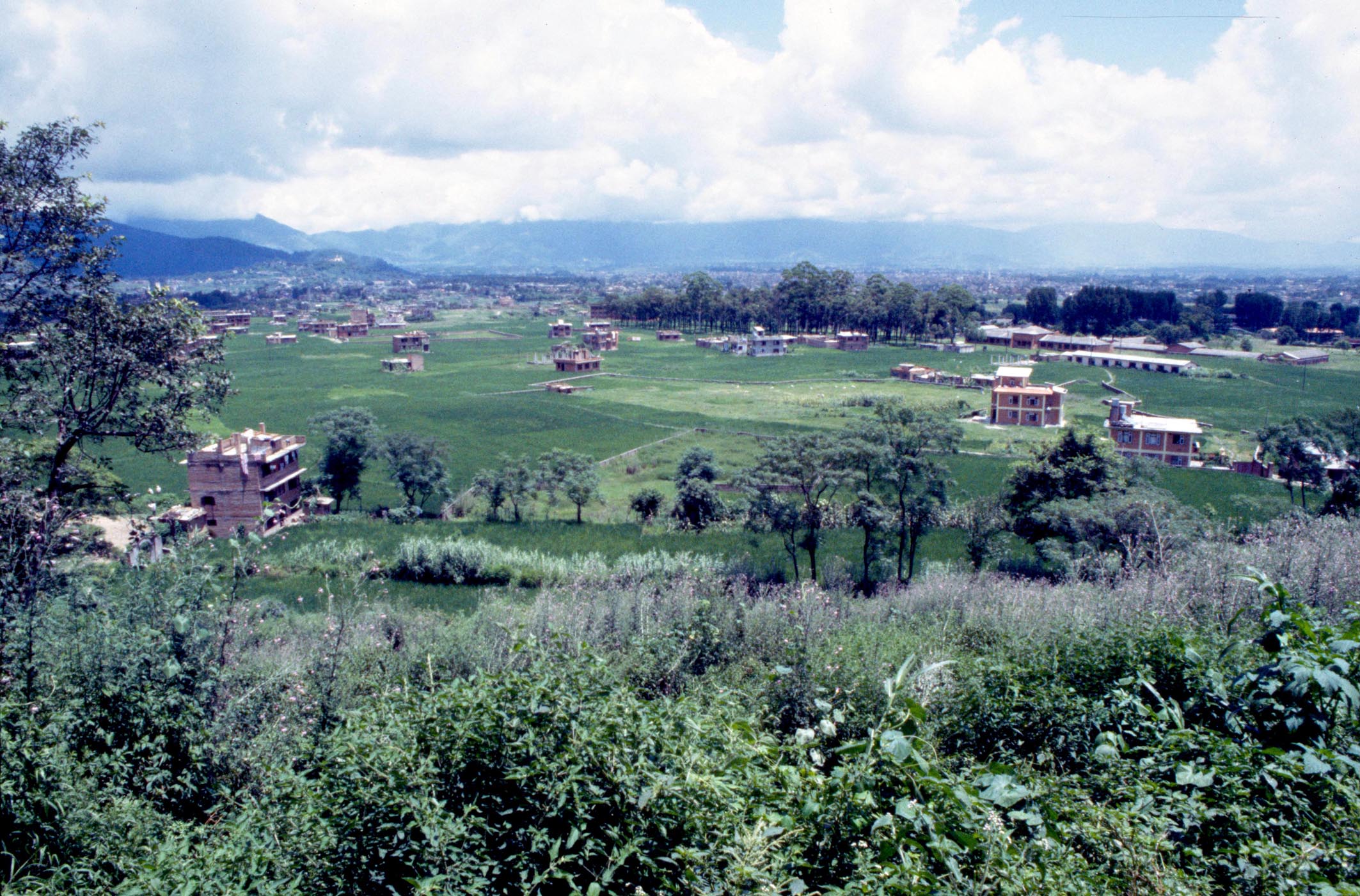
A 1994 photograph shows new buildings beginning to emerge in the
paddy fields. In later years most fields were built over. The loss of
agricultural land has altered the economy of the town and made the
once agricultural community enter the employment market in the
nearby capital, Kathmandu.
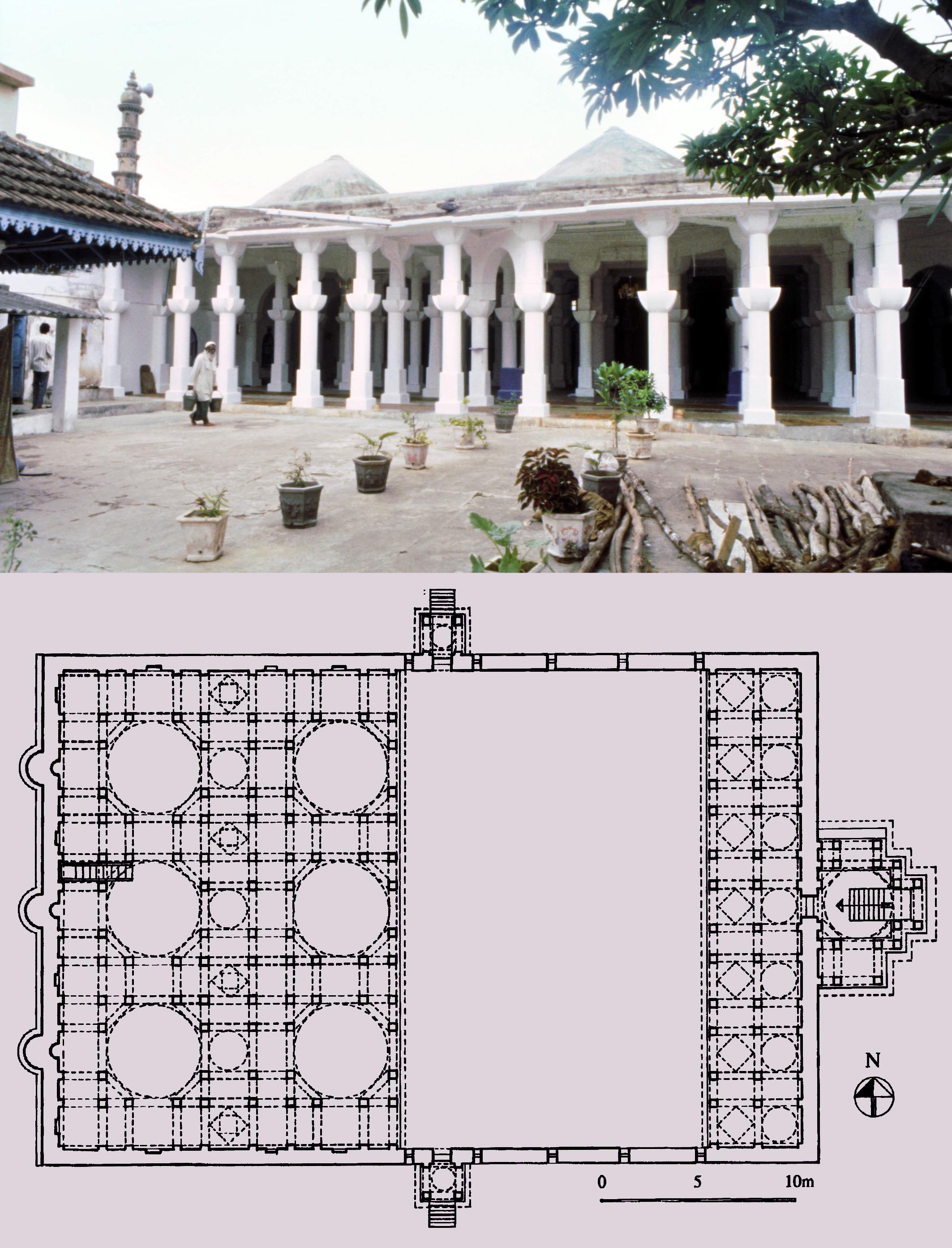
* The Safa Masjid at Ponda, an architectural hybrid, M. Shokoohy, SAS, XIII, 1997, pp. 71-85, figs 1-13.
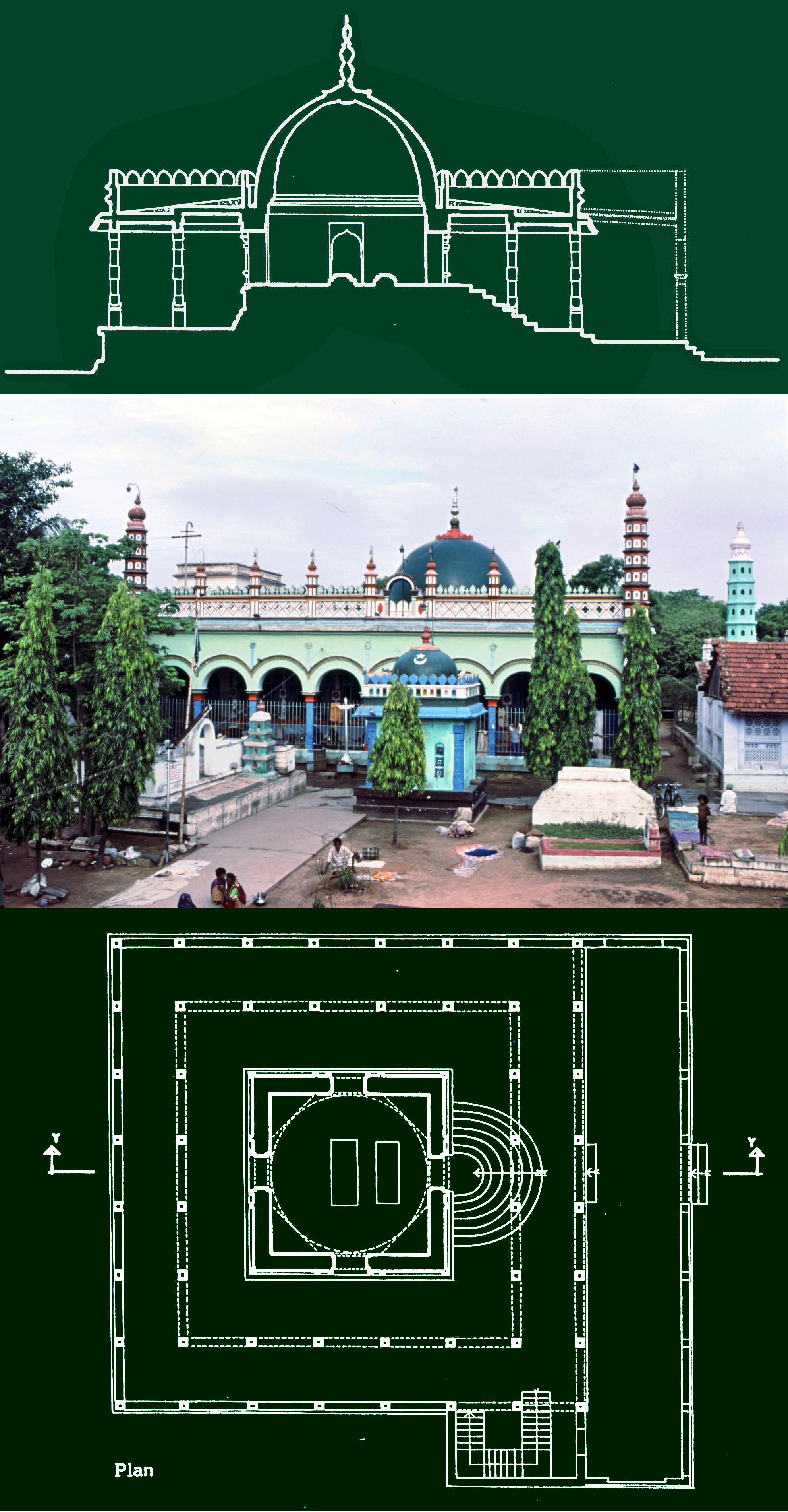
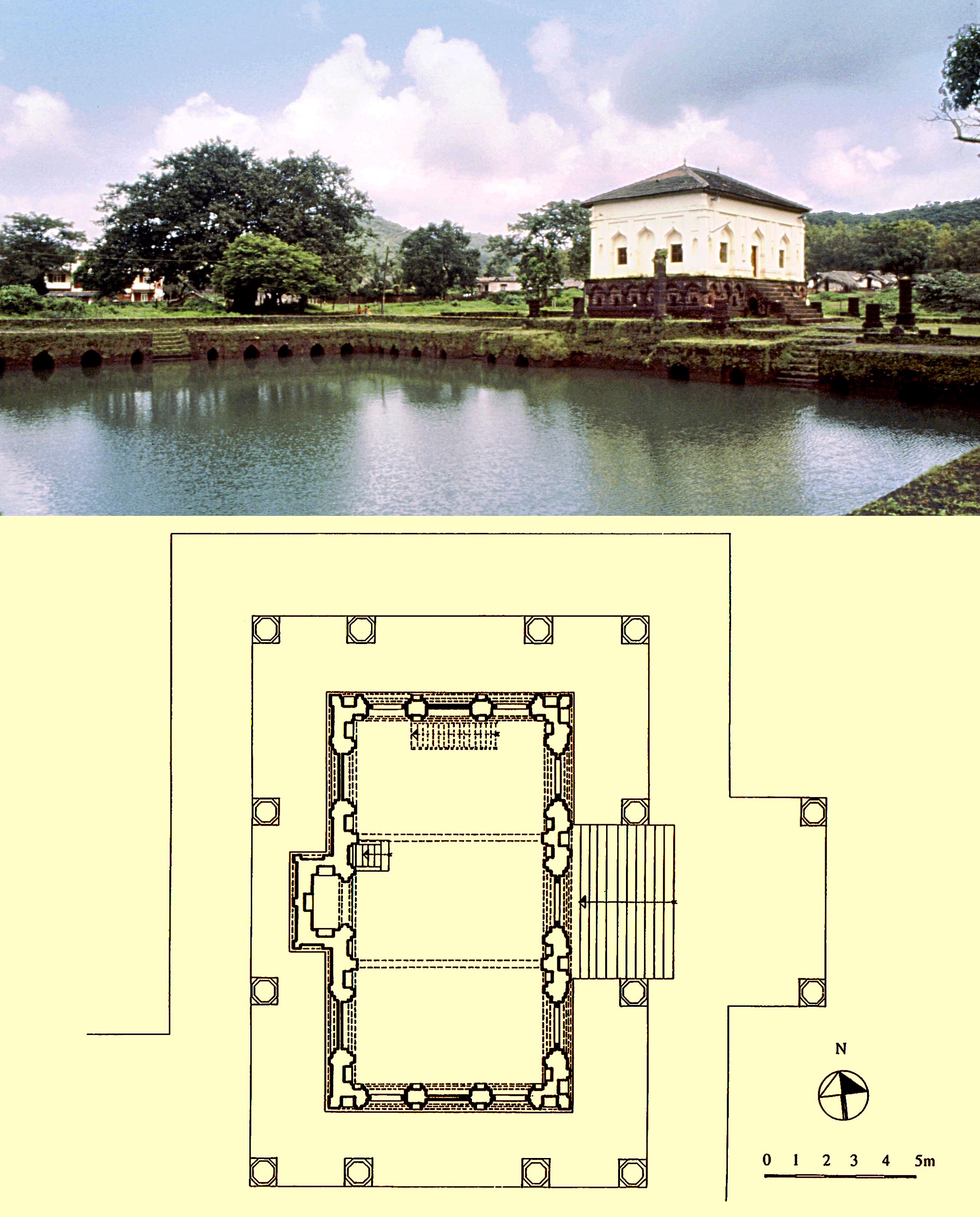 Among the mosques of the coastal towns of South India, the Safa Masjid at Ponda, in the State of Goa, is a curious example, as it is follows neither the style of the buildings of the Muslim settlers of Malabar (the south-western seaboard) nor that of the mosques of the Deccan, which included Ponda before it was taken by the Portuguese in 1763. The mosque is set on a high plinth, and has doors, windows and niches with pointed arches in what might be called a "Deccani" style, but the configuration of its prayer chamber surrounded by a colonnade, as well as the light structure of its wooden roof conforms with the building methods of the Malabar mosques. Its exceptional form alone makes it worthy of investigation, even more so in view of its survival in an area long under the Portuguese, characterised as dedicated enemies of the Muslims, and destroyers of Muslim buildings wherever they found them in South India.
The history of the region and the mosque is investigated, with a full survey of the building together with reconstruction drawings suggesting its original form. It appears that it originally had a two-tiered timber roof structure and in general appearance would have conformed to the local architectural norms of this coastal region of South India. Nevertheless, the unusually high plinth of the prayer hall, the decorative niches and the ogee form of their arches would have been a reminder that the town is within the territory of the Deccan: in short, a reference to the authority of the sultanate in a traditional structure.
The diminutive Safa Masjid was probably built together with a large adjacent reservoir. Tanks of this kind are usually associated with temples, but in the fourteenth century Ibn Battuta mentions that at the congregational mosque of Jurfatan (at or near Cannanor): There is a large reservoir five hundred feet long and three hundred wide, constructed with red stone, around it were twenty eight domes (apparently chatris) each with four platforms and stone stairs
next to the reservoir is the Jamiʽ mosque of the Muslims with a set of steps connecting it to the reservoir.
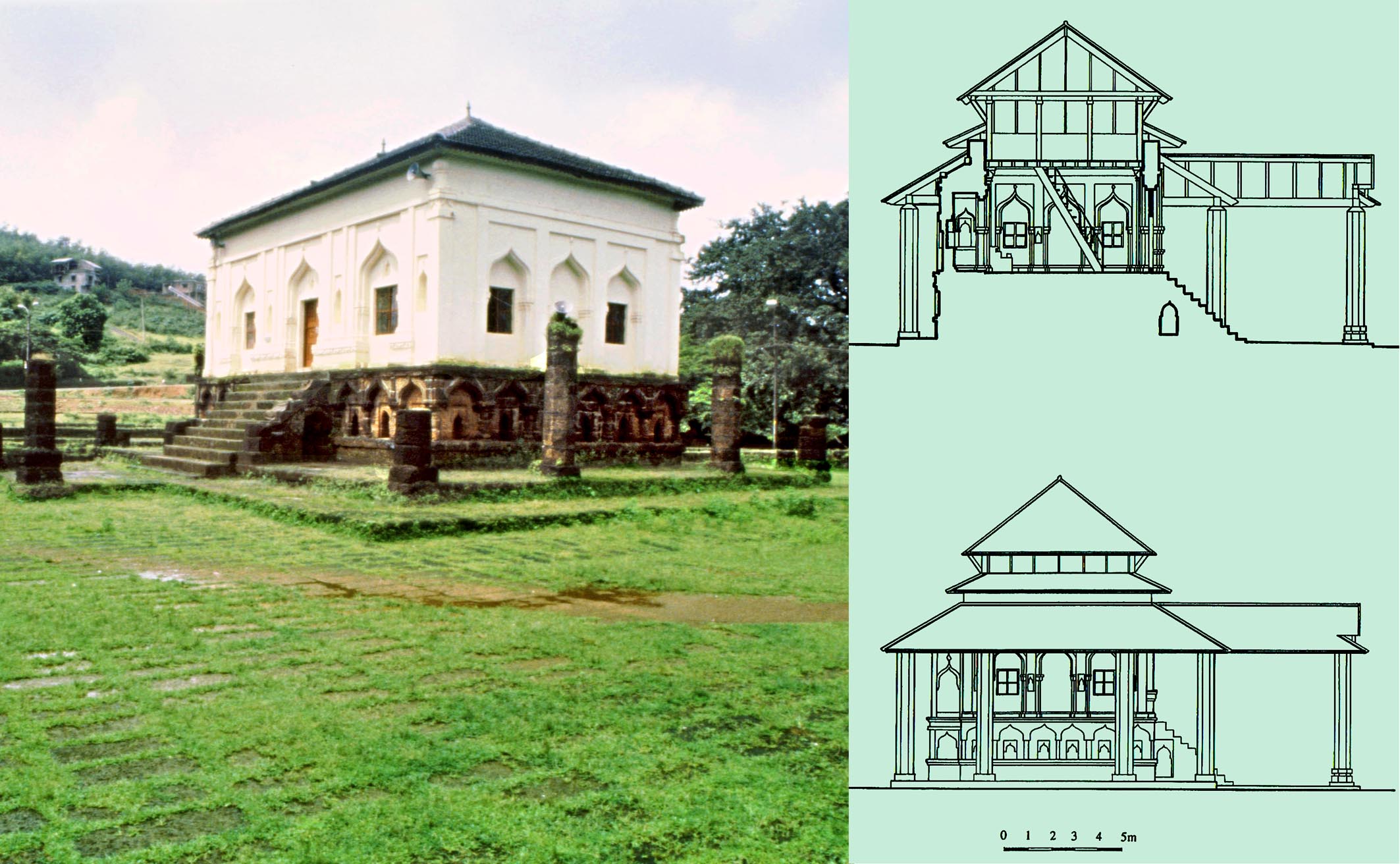 While the local attribution of a 1560 (AH 968-9) date is uncertain, the Deccani influence in the decoration of the mosque, and the lack of features specifically associated with the independent trading communities of the coasts semi-circular arches, or a prayer niche with a semi-circular plan attest to it having been constructed when the area was firmly under the Deccan sultanate and therefore of the mid-fifteenth to mid-sixteenth century and certainly not later than the seventeenth.
The reconstruction drawings have been superseded by those given in Muslim Architecture of South India where the mosque and its adjoining substantial tank are discussed in more detail.
The Safa Masjid and some of the final reconstruction drawings
as presented in Muslim Architecture of South India.
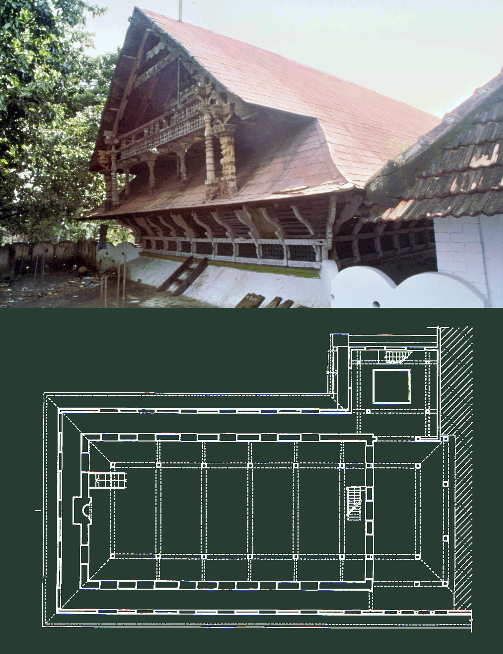
* The town of Cochin and its Muslim heritage on the Malabar coast, South India, M. Shokoohy, JRAS, Series 3, VIII, 1998, pp. 351-394, figs 1-15, pls 1-19.
 Among the cities of South India Cochin is popular with tourists. They walk south along Bazaar Road, with its antique and knick-knack shops along with wholesalers of imported goods and merchants offices, visit the Synagogue of the White Jews, miss that of the Black Jews, walk south a little more to see the Old Palace and Museum and terminate their journey. Some may also take in the north of the island and the site of the old European forts ‒ one built on the site of the other ‒ where the much modernised historic churches are found. Few, if any, go south of the palace to the end of Jew Town Road to enter the Muslim quarter with its magnificent sixteenth-century mosque and other monuments.
The paper introduced these monuments to the scholarly world and put them on the map. The large and impressive Shafei Jamiʽ mosque or Chembattapalli is one of the rare examples of a substantial South Indian mosque, which, in spite of some later additions, has survived without significant alteration. In its structure of plain but massive stone walls and wooden columns supporting a timber superstructure, the mosque displays the regional vernacular. The joinery is simple, even crude, but devised in a manner that the structural elements fit together and support each other in equilibrium, but are flexible and storm-resistant. Such skilful detailing is an indication that the builders were using well-attested methods, established over the centuries in response to the climate and locally available materials. The mosque bears a bilingual inscription: the Malayalam version records the renovation of the mosque in the year 180 of Puduvaipu, the local era of Cochin (AD 1520-21) and the Arabic version gives the date AH 926 (AD 1519-20), fixing the date to 1520.
In spite of a modern concrete hall added to the front of the Shafeʽi Jamiʽ or Chembattapalli, the original plan and structural details are almost entirely preserved.
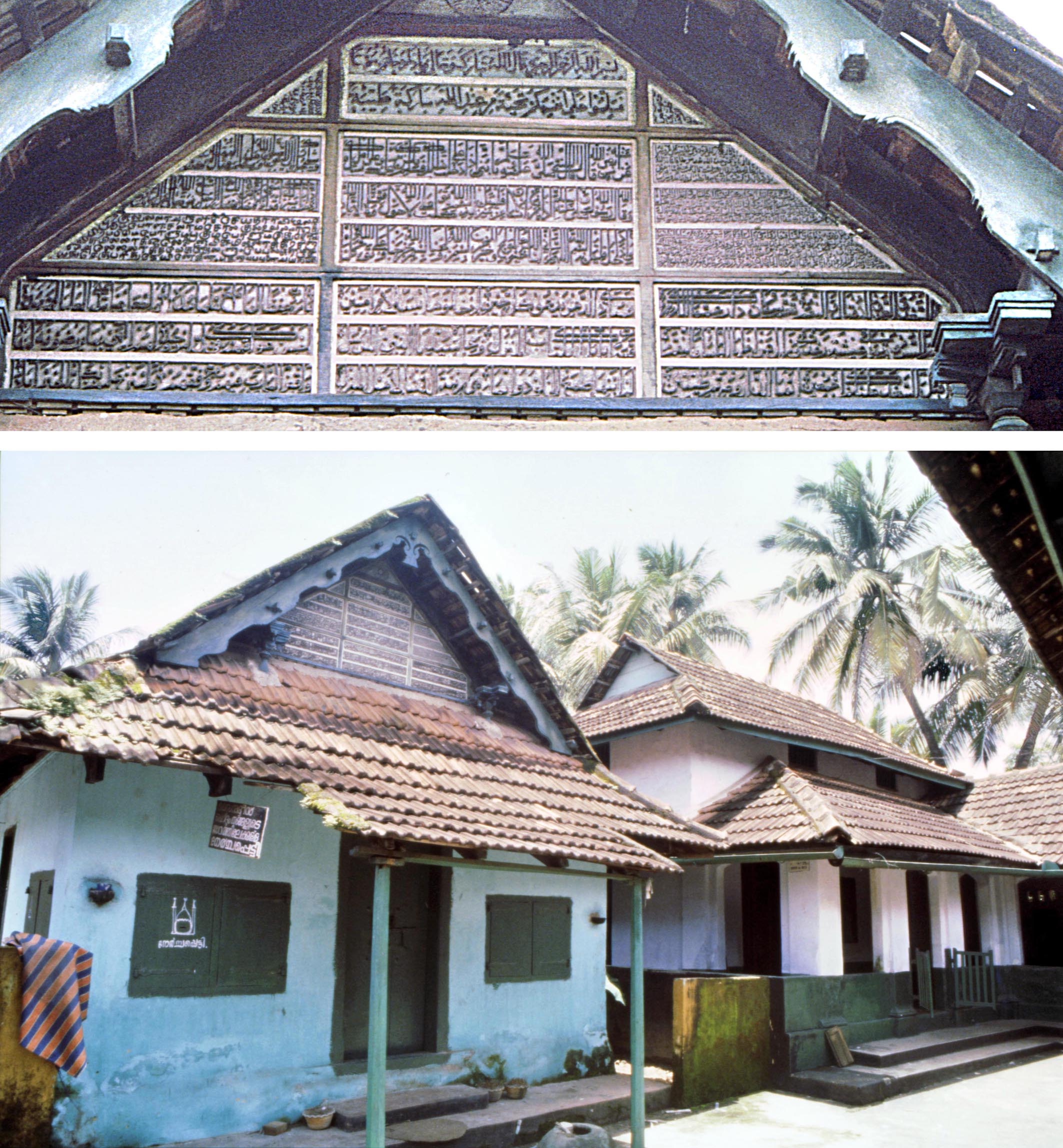 Not far from the mosque are two other buildings of considerable age, both built over the tombs of local religious personages, and regarded as shrines. One of these, over the tombs of Sayyid Isma`il and Sayyid Fakhr al-din Bukhari, is located near the Jami`, and the other is the revered Dargah of Zain al-din, which together with its mosque is of considerable interest. Until recently Zain al-dins shrine bore a number of religious inscriptions recorded in the paper, but which were dismantled and sold sometime before 2006. Zain al-din is a well-known local personage and is the ancestor of Shaikh Ahmad Zain al-din: the well-known author of the Tuhfat al-Mujahidin.
Apart from the Muslim monuments, the rapidly disappearing Jewish community of Cochin is considered, as well as the history of the town from its earliest times to the dominance by first the Portuguese and later the Dutch and British. An extended and comprehensive account of Cochin may be found in Muslim Architecture of South India.
A view of the shrine of Zain al-din and its inscriptions,
still in situ in 1994. While the Arabic inscriptions are
Quranic or bear religious texts, the Malayalam and
Tamil texts bear a local date of Puduvaipu 84 (1425 AD).
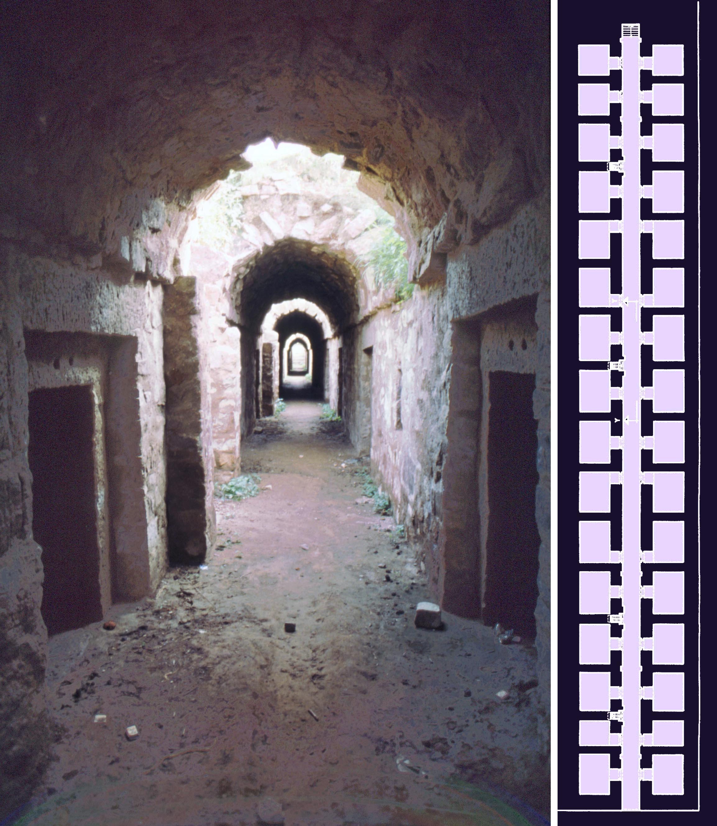
* The Dark Gate, the Dungeons, the royal escape route, and more, survey of Tughluqabad, second interim report, M. and N. H. Shokoohy, BSOAS, LXII, part 3, 1999, pp. 423-461, figs 1-14, pls 1-11 (22 photographs).
 The citadel of Tughluqabad is the focus of the second report on the survey of Ghiyath al-din Tughluqs capital. After its desertion on the death of the sultan the citadel was occupied for a short period in the late Mughal period and at first glance might appear to have retained little of the original Tughluq palaces. However, once the extent of the later occupation was investigated, the remains revealed many original features, including the massive platform of what had been the pavilion with a golden dome, described by Ibn Battuta. Rather than steps, the pavilion was accessed by ramps; these became a feature of later Tughluq palaces. Inside the platform a series of windowless and dark chambers with thick stone walls flanking a long corridor ‒ now referred to as dungeons ‒ were probably safe storerooms, perhaps of the treasury.
Within the citadel, walls of some large halls of the royal apartments have also survived, sometimes incorporated into other buildings. An intriguing feature is an escape route from the citadel to the lake outside the fort: a steep stepped passage hidden in the walls and designed in a manner that once the sultan and a few of his associates entered it, the entrance could be blocked with a stone slab which would appear as part of the paved floor, and could only be opened up if it were smashed. The low narrow passage was also designed in a manner that if the enemy managed to follow the escape party, the attackers would be negotiating the steps backwards, while the defenders could fend them off from below. The route was, of course, never used, as Tughluqabad was never attacked by enemies.
The Andheri Gate is the only gate standing intact and consists of a corridor flanked by two chambers, a basic form employed for all the other gates, many of which are larger and more complex than this example.
 The paper presents an updated version of the town plan, superseded later by the plans published in the book. In the town the processional street, the market squares and the market street, known as the Khass Bazaar, are explored and detailed drawings of the shops given with suggested restored appearance. A building, which was most likely a theological college (madrasa), was also surveyed, while its ruins were being demolished to salvage the stone for new houses nearby. The madrassa was one of the few structures in the town to have preserved its foundations.
As part of the continuous investigation of the town walls to establish the method of construction of such a massive fort and town in about two and a half years the only town gate, the Andheri Gate (Dark Gate) was surveyed. This is the sole gate of Tughuqabad that is still virtually intact and has retained its roof. The survey of this gate revealed the general layout of the Tughluqabad gatehouses and helped interpret ruined portions of other gates for later surveys presented in the Third Interim Report and in Tughluqabad: a paradigm of Indo-Islamic urban planning and its architectural components.
The cells known as the Dungeons are a series of chambers flanking a long
corridor built into the platform of the royal private apartments. They would
have been inaccessible to all except the sultan and his very few confidents
who could enter the citadel.
Fath Jang, Ebrahim Khan (or Mirza Ebrahim), M. Shokoohy, EIr, vol. IX, fascicle iv, 1999, pp. 421-422.
Mirza Ibrahim Khan Fath Jang was a son of Iʿtimad-al-daula Ghiyath Beg Tihrani and brother of Nur-i Jahan, the influential wife of the Mughal emperor Jahangir (r. AH 1014-37/AD 1605-27). Together with other members of Iʿtimad-al-Daulas family, Mirza Ibrahim entered Jahangirs service and was first made a paymaster (bakshi) and inspector of Gujarat, responsible for reporting on the events of the region to the emperor, and within a year was given the rank of 1,000 men. After Jahangir married Nur-i Jahan in 1020/1611 Ibrahim returned to Agra. He was awarded the title of khan in AH 1023/AD 1614-15.
Ibrahim Khan first served at court as a private secretary to the emperor (bakhshigari-yi huzur), but by the end of AH 1024/AD 1616 he was made governor of Bihar and sent there to take over the region of Khukharha near Patna, an area well known for its diamond mines but hidden deep within dense and inaccessible forests and controlled by a local Hindu landlord. Ibrahims campaign was successful, and earned him the title of Fath Jang. He was made governor of Bengal and Orissa and held this post until AH 1033/AD 1623-24, when he was killed in battle defending the fort of Akbarnagar against the army of Shah Jahan, who had rebelled against his father. A full bibliography is included.
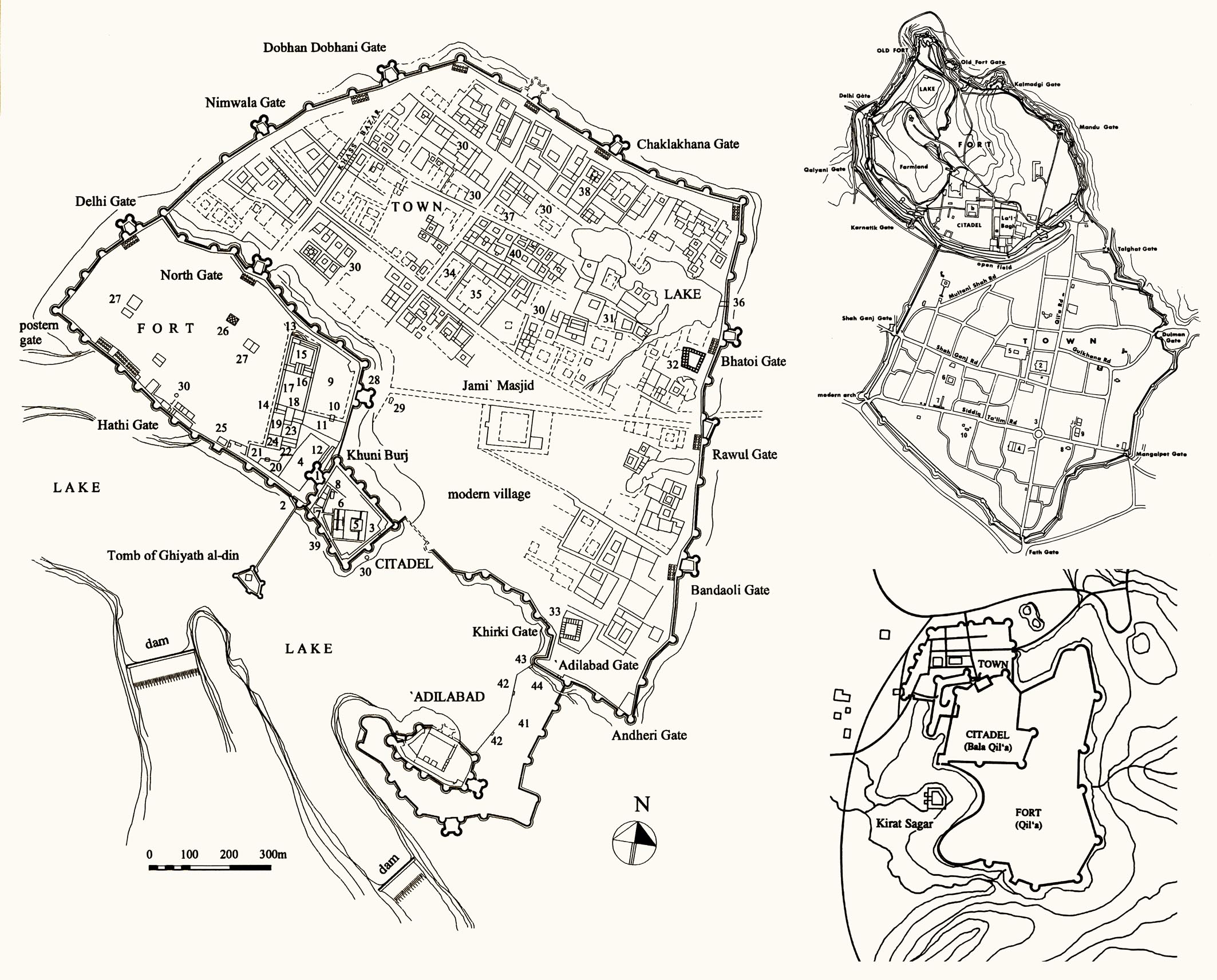
* Pragmatic City versus ideal city: Tughluqabad, Perso-Islamic planning and its impact on Indian Towns M. and N. H. Shokoohy, UDS, V, 1999, pp. 57-84, figs 5.1-5.28 (16 drawings, 12 photographs).
 ISBN: 978-1-870606-07-3
ISSN: 1358-3255
Complementing the first and second interim reports on the Survey of Tughluqabad (BSOAS, 1994 and 1999) the concept of urban planning in pre-Islamic India is explored, along with the reasons for the introduction of Perso-Islamic plans to India in the thirteenth and fourteenth centuries, with Tughluqabad as the earliest surviving site with such a layout. The concentric plan of traditional early mediaeval towns is analysed noting their basis on celestial diagrams with the temple-palace at the centre and the various castes living around it according to rank. Archaeological sites are noted as well as surviving examples, including Madurai in South India.
The town plan of Tughluqabad (left) comprising three main components: town, fort and citadel, was to become a prototype for almost all Indian cities from the fourteenth century to the end of Mughal period. In Bidar (top right) the town is almost the size of the citadel and the fort, while in Chanderi (bottom right) the areas taken up by the town and citadel are similar but the fort is three times larger.
 A feature of Perso-Islamic towns is their royal square (maidan-i shah)
in front of the main gate, the grand square being either within the fort
or outside it, and leading to the palace buildings. As with Tughluqabad,
the square in Bidar is located inside the fort ‒ now known as Laʽl Bagh
the Red or Ruby Garden.
These towns, while reflecting the social hierarchy of the population and providing for an ordered society during peacetime, were vulnerable to external attack, as an army could besiege the town walls, starve the population and take over with little conflict. Indeed some eleventh and twelfth century sultans of Khurasan (Eastern Iran) made a habit of raiding and looting the cities of north and west India using this simple strategy.
The Perso-Islamic cities were, on the other hand, designed to make sieges practically impossible, as the fort, rather than being centrally placed was set to one side of the town with the citadel again not surrounded by the fort, but occupying the optimum defendable spot to one side, and allowing the walls of the actual town to spread for several miles. To besiege such a city took a large army, not easy for a mediaeval ruler to raise and provision. The introduction of the foreign concept to India soon changed the planning of almost all Indian cities, and many of the older concentric towns added a fort to one side, altering the urban fabric and street layout.
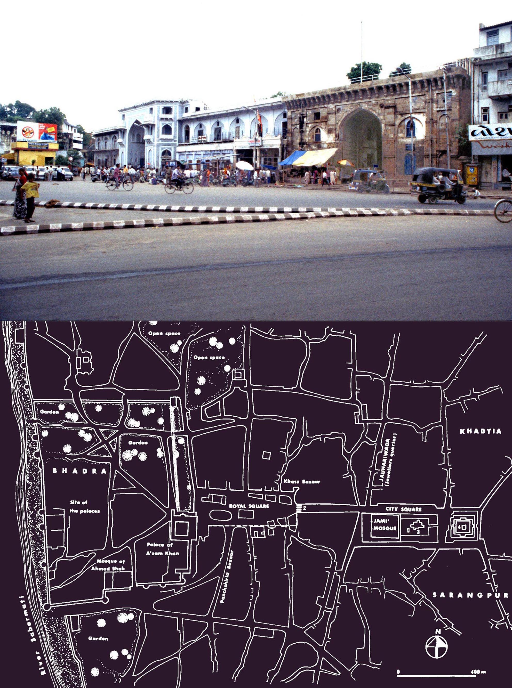 Apart from considering the Perso-Islamic plan of Tughluqabad and many other later towns, salient features of such cities, particularly the congregational mosque and the main urban square ‒ usually known as the royal square (maidan-i shah) ‒ which provided an interface between the ruler and subject are discussed.
In Ahmadabad the royal square, located outside the main palace gate, opens to a processional street integral to the design of Perso-Islamic cities leading to the Jamiʽ (congregational) mosque. Although most of the site of the maidan-i shah of Ahmadabad is now built over, what remains forms an impressive open space.
* The Karao Jami mosque of Diu in the light of the history of the island, M. and N. H. Shokoohy, SAS, XVI, 2000, pp. 55-72, figs 1-19 (4 architectural drawings, 15 photographs).
ISSN 0266-6030
In the ex-Portuguese colony of Diu there stands an impressive old mosque. Its interest is more than architectural as its very survival under the Portuguese may throw light on some aspects of the history of the Portuguese in India and their relationship with the Muslims of the region, particularly with regard to the infamous practice of burning the mosques of many South Indian ports.
Ludovico di Varthema, who visited Diu in 1503 or 1504 notes: This city is subject to the Sultan of Combeia (Gujarat), and the captain of this Diuo is one named Menacheaz (Malik Ayaz). Four hundred Turkish merchants reside here constantly. This city is surrounded by walls and contains much artillery within it", and Barbosa in c. 1515, gives vivid descriptions of Diu, its administration and trade before it fell into the hands of the Portuguese. Varthema records: The king keeps a Moorish governor in this place called Melquiaz; an old man, and a very good gentleman, discreet, industrious, and of great information. He always keeps with him many men-at-arms, to whom he pays very good appointments.
 In the turbulent relationship between the Gujarat sultanate and the Portuguese, the former was in control of the town and the latter their fort there. Later, during the Mughal period the Portuguese, while taking over the town, chose to have a non-confrontational policy with the mighty empire and, unlike other Portuguese territories in India, Diu sustained its Muslim population. The Karao mosque, however, pre-dates the Portuguese and even the sultanate of Gujarat. Its plan and use of temple spoil indicate that it was built at the time of Delhis conquest of Gujarat at the beginning of the fourteenth century. Incorporating a variation of the local style of the late thirteenth to fourteenth century mosques of Gujarat, it differs from those of the fifteenth and sixteenth century, as in this building the colonnade opens to the courtyard without having a screen wall with one or more large arched openings set in front of the prayer hall, typical of later Gujarati mosques. The main entrance of the Karao Jami, with its domed canopy and an entrance and stairs below, seems to be a haphazard re-assembly of the entrance to a Jain temple. The Diu mosque is indeed the oldest monument on the island and has remained in everyday use for over seven hundred years.
The spacious Karao Jamiʽ mosque, one of the few surviving
first-generation mosques of the sultanate of Delhi in Gujarat,
built at the time of, or soon after, the Delhi take-over of the
region in AH 698 (AD 1298-9).
Giat Beg (Ghiat-al-din Mohammad Tehrani) Etemad-al-dawla, M. Shokoohy, EIr, vol. X, fascicle vi, 2001, pp. 594-595.
 I`timad al-daula was the grand vizier of the Mughal emperor Jahangir and father of the emperor's wife, Nur-i Jahan. He was the younger of the two sons of Khwaja Muhammad Sharif Hijri (d. AH 984/AD 1576-7), Minister of Yazd and later Isfahan in the Persian court of the Safavid Shah Tahmasb. Muhammad came from a learned family of Tehran, and one of his brothers was Mirza Ahmad Tehrani, a close companion of Shah Tahmasb. Ahmad's son Mirza Amin Razi is renowned for his book Haft Iqlim, and Ghiyath Beg's brother was the poet Mohammad Tahir, known as Wasli.
After the death of his father Ghiyath Beg lost favour in the court of Isfahan, and together with his family escaped to India entering the court of the Emperor Akbar, and at the time of Jahangir was appointed vizier of half of the empire, with the title of I`timad al-daula. While one of his sons and his son-in-law (the former husband of Nur-i Jahan) joined the camp of Jahangirs enemies, Ghiyath Beg retained his status in court and gradually became extremely powerful after Jahangir married Nur-i Jahan.
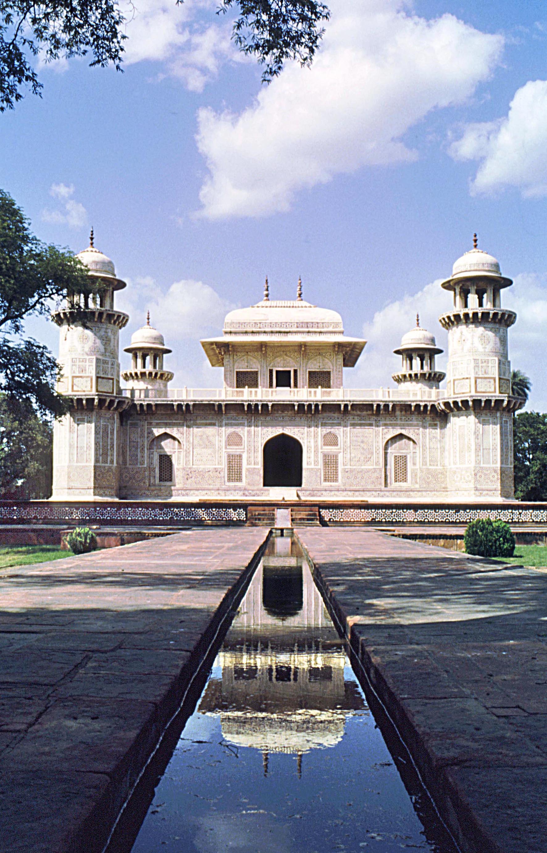
Ghiyath Beg was known for his refined manners, his knowledge of literature, and his skill in calligraphy. In the words of Ma'athir al-Umara: "He was always conscious of the future, self-composed, and did not harbour grudges even against his enemies. He was not at all oppressive, and in his household there were no fetters, chains and whips, nor words of abuse." His tomb in Agra is one of the finest monuments of the Mughal period and a forerunner of the Taj Mahal. A full bibliography is included.
The tomb of Iʽtimad al-daula, built under the supervision of his daughter Nur-i Jahan. Although a small building fit for a highly respected minister the workmanship of the finely carved marble facades, inlaid with coloured stone, is equal to that of Taj Mahal.
* The Zoroastrian fire temple in the ex-Portuguese colony of Diu, India, M. Shokoohy, JRAS, Series 3, vol. XIII, i, 2003, pp. 1-20, figs. 1-17 (6 drawings, 11 photographs).
ISSN 1356-1863
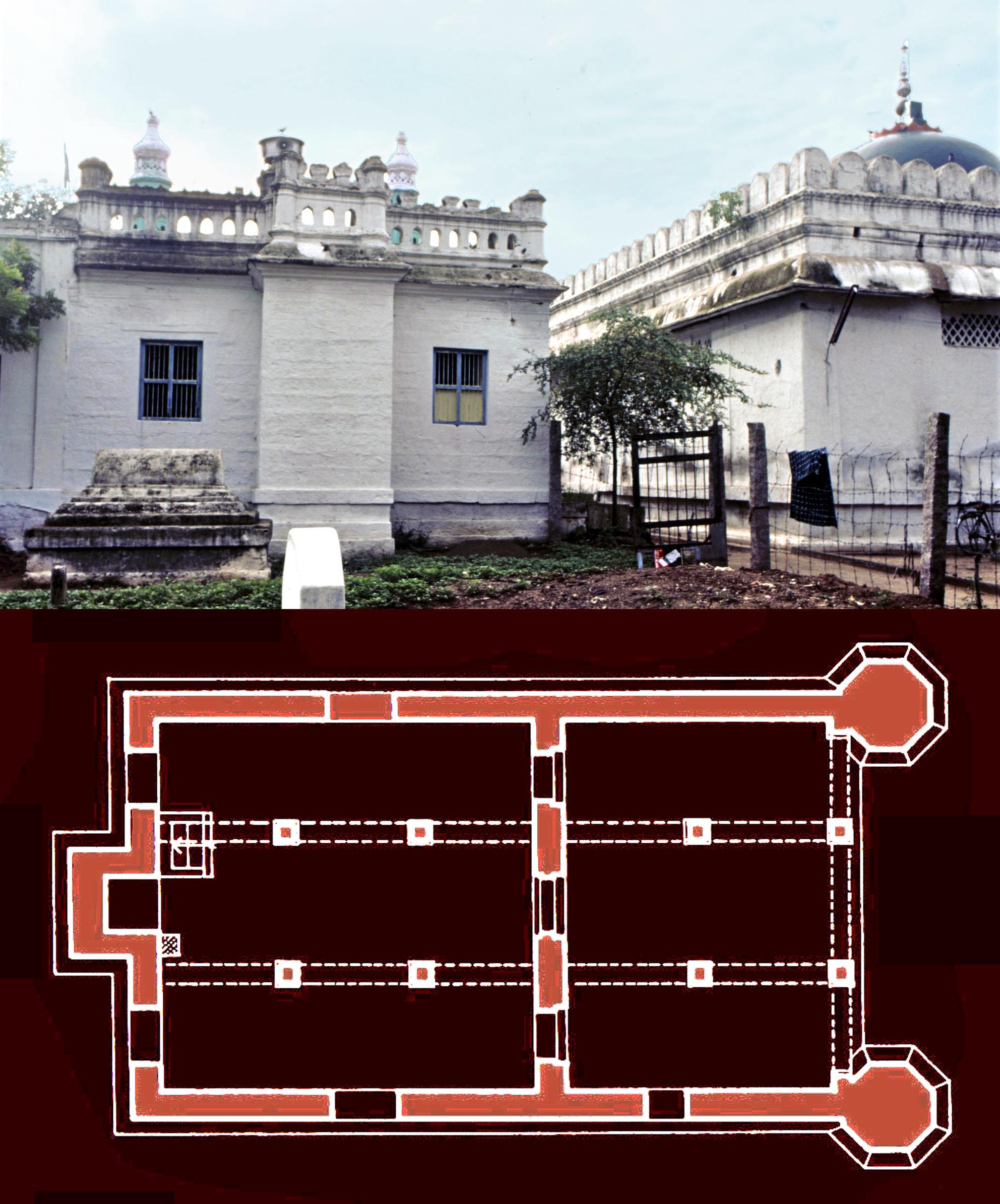
 Although the last Zoroastrian families left the island in about 1950, the survival of the fabric of the fire temple of Diu for over half a century without much alteration is mainly a result of decisions made by the last members of the community. The sacred element in a fire temple, the fire itself, should be kept alive at all times and when a community leaves an area the fire is taken away. The building in itself has no sanctity and can be left abandoned or used for other purposes. This has been the fate of many of the grand fire temples in Iran over their long history and particularly after the dominance of Islam. The community in Diu, however, preferred the building to be re-used in an appropriate way for the benefit of all people of the island. It was donated to the Church and a group of nuns from Goa were sent to set up a convent there. The building, now St. Annes Convent, is a centre for service to the islands community and also has a successful infants school accepting children of all castes and creeds.
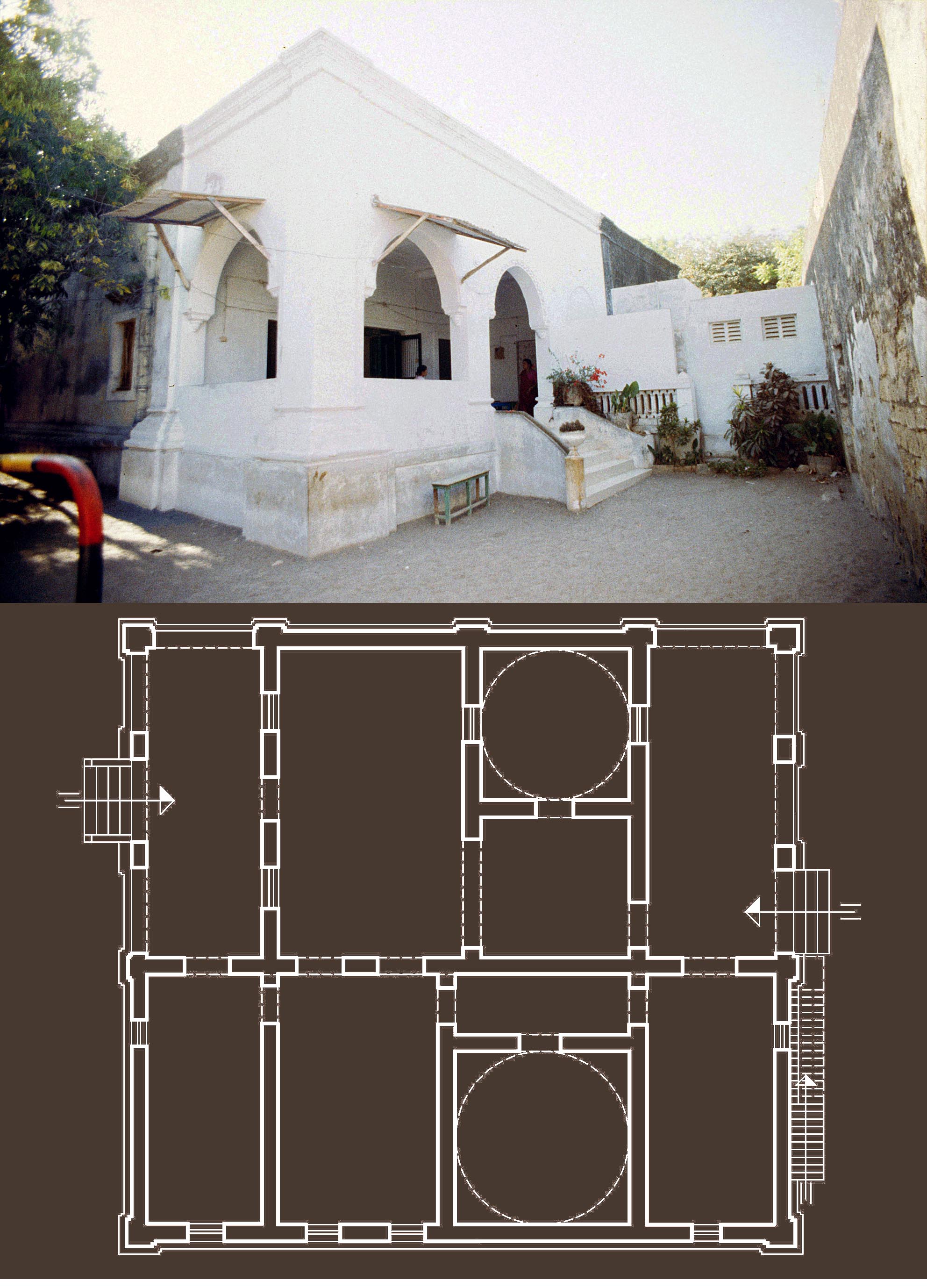
In general form and in its structural elements the building is a product of the Portuguese colonial methods employed in Diu, but, as with most modern and historic fire temples the building has a simple plan, consisting of two interconnected halls each with an arched portico and two domed chambers. The northern part of the building was for the use of the congregation with the small domed chamber in a focal position housing the fire altar where the sacred fire was brought for public worship. The fire was, however, kept alive permanently in the larger chamber with its adjoining rooms closed to the public, being used by the priests for keeping liturgical objects and fire-wood.
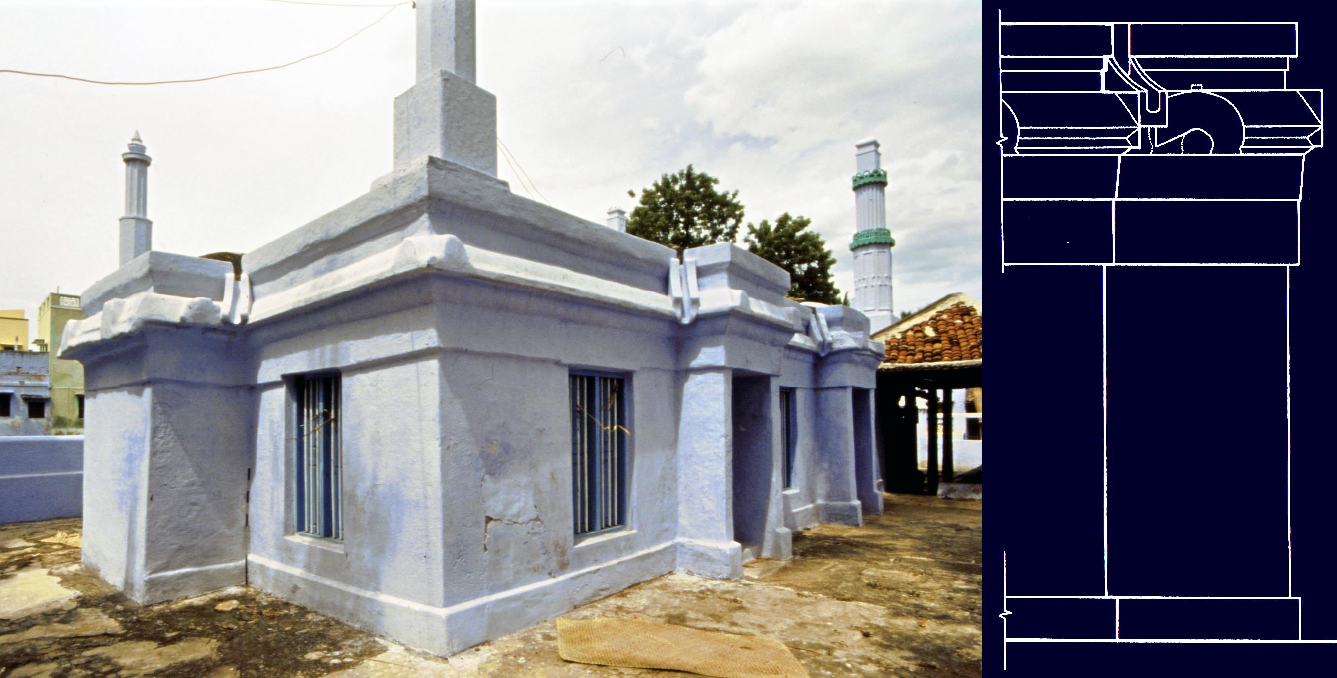
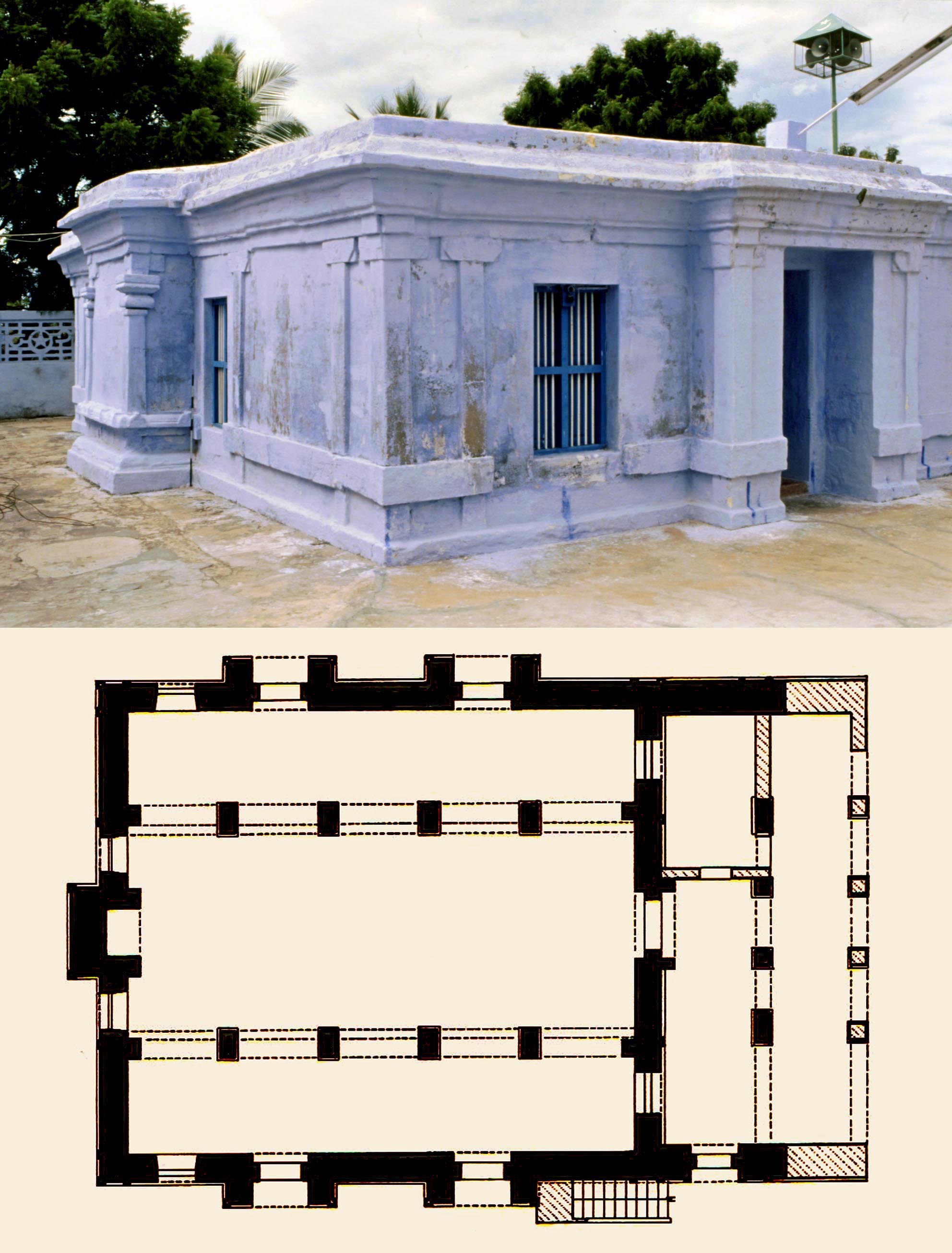
Plan and exterior view of the fire temple of Diu. A straight
wall separates the two porticos, the halls and the small
domed chamber open to worshipers from the series of
chambers which could be accessed only by the priests,
including a large domed windowless chamber.
 The good state of preservation of the structure provides a rare opportunity to gain an insight into what are perceived as recent architectural traditions for Indian fire temples. The sacred nature of these buildings often forbade immediate access for the purpose of survey and photography. As a result there has been little study on the architecture of functioning fire temples and much needs to be done before a cohesive picture of the design development of modern temples can emerge. The paper also discusses in depth the liturgical requirements which tie these building to their historical predecessors, now mostly in ruins, in Iran.
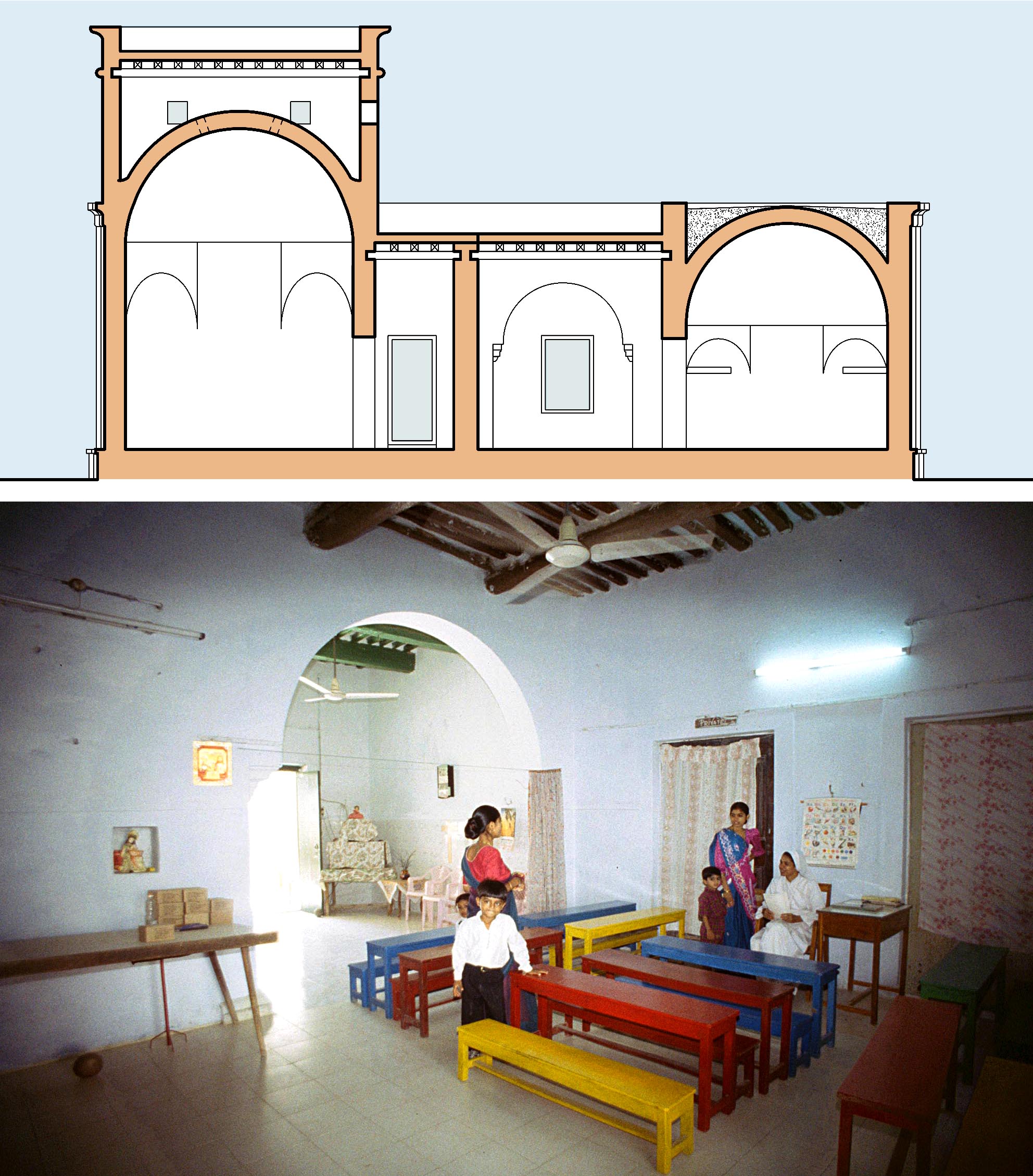
Above, a section through the two domed chambers and one of the assembly halls and below, a view of the same hall now used as a classroom.
* Tughluqabad, third interim report: gates, silos, waterworks and other features, M. and N. H. Shokoohy, BSOAS, vol. LXVI, i, 2003, pp. 14-55, figs 1-18, pls 1-27.
ISSN: 0041-977X
EISSN: 1474-0699
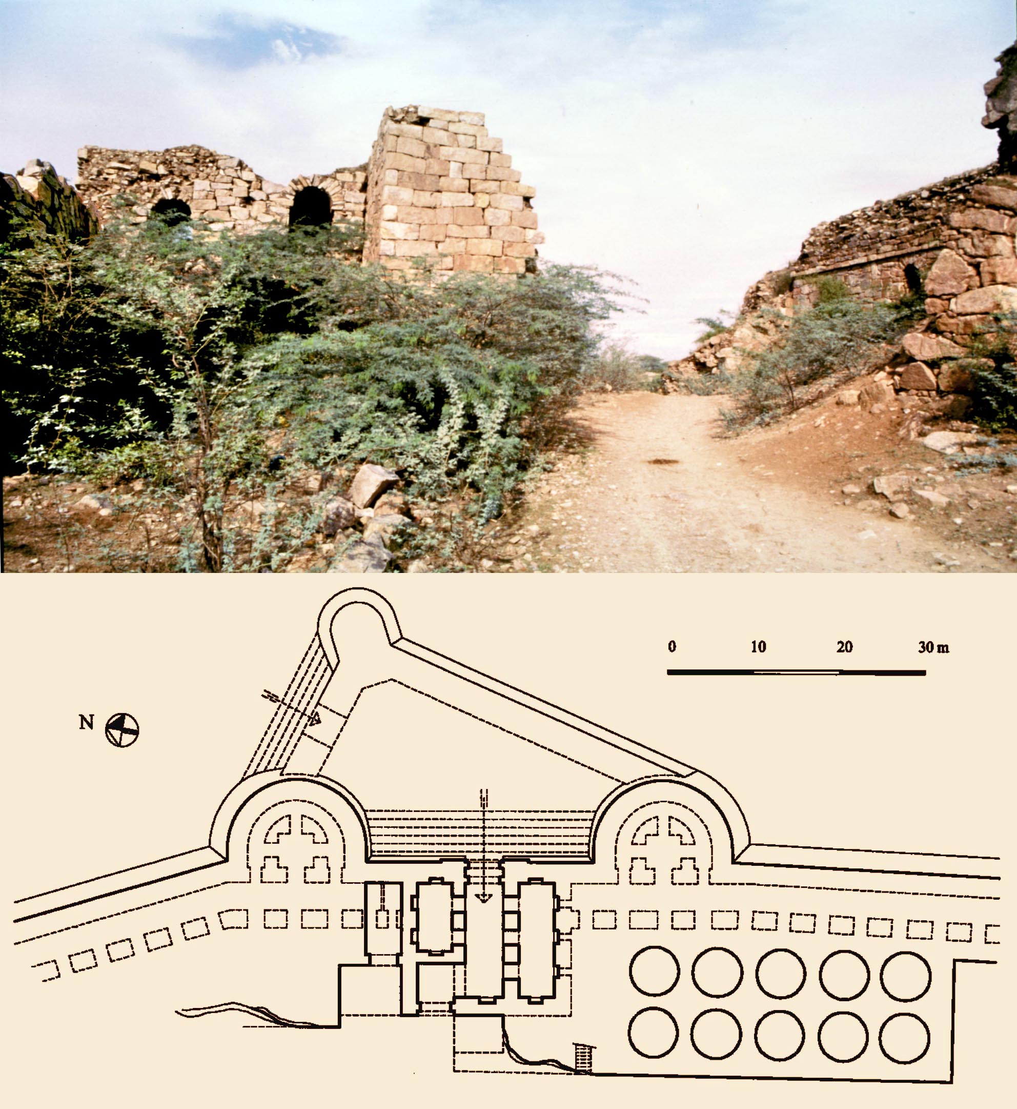
The Tughluqabad gates are similar in concept, but each is unique in layout as they had to be inserted into the gaps left between the fortification walls, which were built first. The Rawul gate, with its adjacent silos, is unusual in having a triangular, rather than trapezoid outer court and on the north an additional chamber (at left in photograph) to fill the long gap left between the flanking walls.
The last interim report focuses on the infrastructure of Tughluqabad as well as its urban form, and how the town walls and the town itself could be constructed in only two and a half years. In the 6th season of fieldwork in 1999, the remains of two of the gates in the fort and some of those in the town were recorded, as well as the silos attached to some gates. The residential areas of the north of the town were further investigated including a sizeable mansion. Within the fort the remains of a reservoir, a main supply of water, was also detailed. Photographs and measured drawings of all these features are given together with an updated town plan.
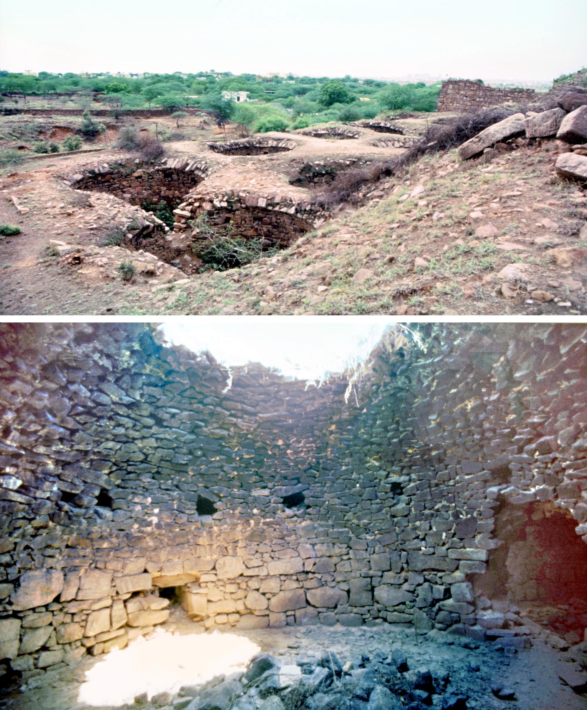 One of the prominent features in Tughluqabad is the extensive lake created to the south of the town, as part of the original design, not only to provide water but also to create a micro-climate with increased humidity which would have moderated the temperature during the dry season. The water was controlled by a single ingenious sluice gate ‒ sophisticated in design, but simple to operate. A fresh survey gives details of how it worked; drawings include a three-dimensional reconstruction showing how the water of a lake almost as vast as the town itself could be controlled by a single person ‒ a fresh design concept, which has not been seen elsewhere in India.
In 1999 the Tomb of Ghiyath al-din Tughluq and the citadel of Adilabad were also surveyed, and are published in Tughluqabad, a paradigm for Indo-Islamic urban planning and its architectural components.
The Rawul Gate, like most of the gates, incorporates a structure
with ten silos, circular in plan and roofed with flat domes. The grain
stores were filled from small apertures in the roof, but access could
only be achieved by order of the sultan to dismantle the dome or
part of it, in case of famine.
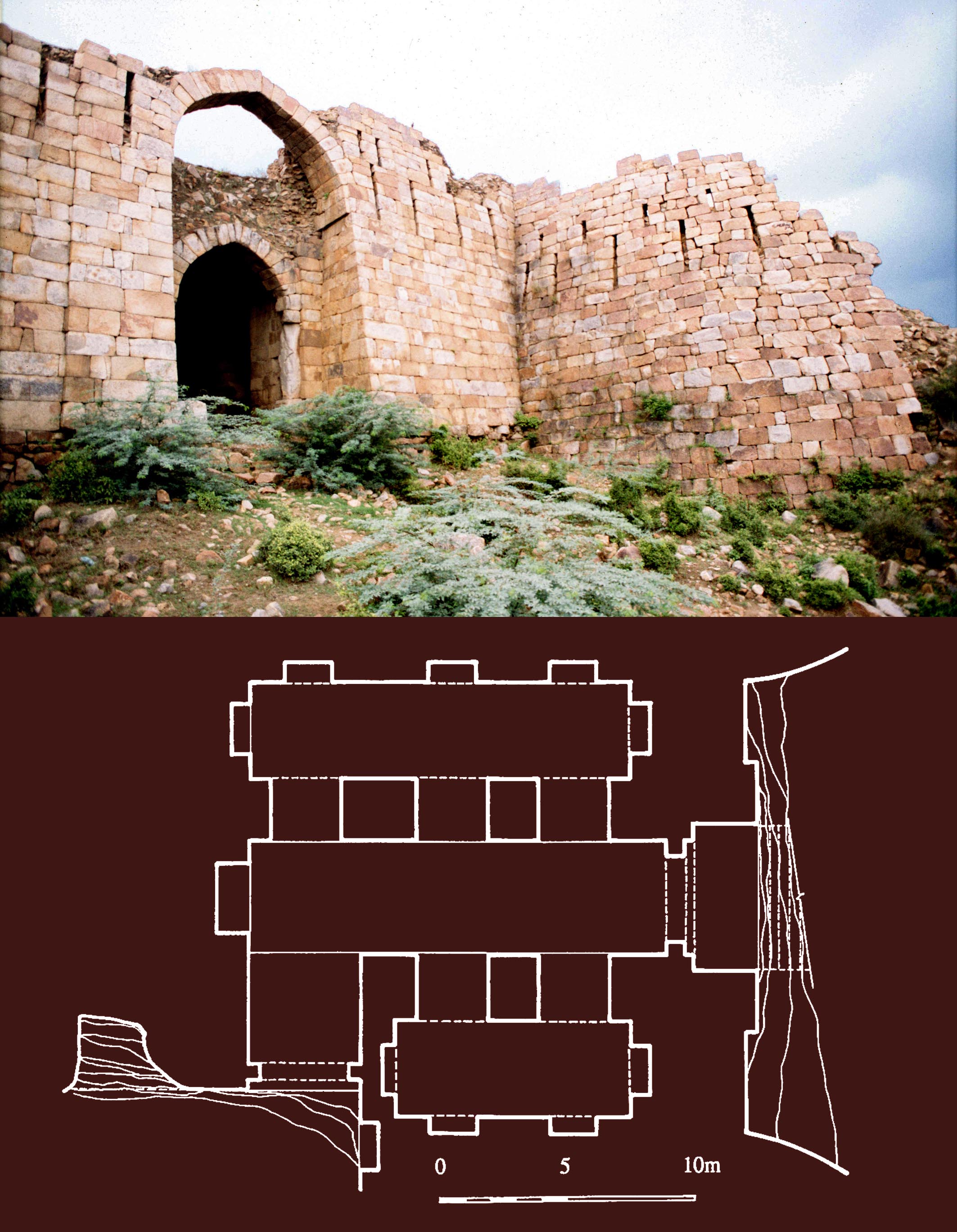
Hasan Gangu (Kangu or Kanku): Ala al-din Hasan Bahman Shah, M. Shokoohy, EIr, vol. XII, fascicle i, 2003, pp. 33-34.
Hasan Gangu (Kangu or Kanku) was a Khurasani adventurer at the court of Muhammad ibn Tughluq at Delhi, and after rebelling against his master declared himself Sultan of the Deccan with the title ʿAla al-din Bahman Shah (r. AD 1347-57). He claimed descent from the Sasanian Bahram Gur and founded the Bahmanid dynasty, which lasted until AD 1527. He was the son of Keykawus Muhammad b. ʿAli b. Hasan; and his uncle Malik Huzhabr-al-din Zafar Khan was a noble at the court of Sultan ʿAla al-Din Khalji and the governor of Multan and the Punjab.
Hasan is said to have been originally from Ghazni, entering the services of Sultan Muhammad ibn Tughluq together with his brothers who were all given small fiefdoms in the Deccan. Hasan was eventually made Governor of the district of Gulbarga with the honorary title of Zafar Khan. When the brothers revolted they were at first defeated and the two of them put to death, but Zafar Khan joined the other rebellious nobles and on 24 Rabiʿ II 748/3 August 1347, he was proclaimed Sultan ʽAla al-din Bahman Shah. Muhammad ibn Tughluq, immersed in troubles, never returned to the Deccan and died soon afterwards.
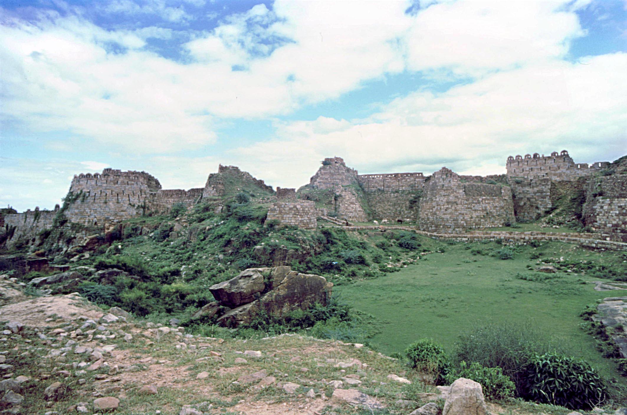
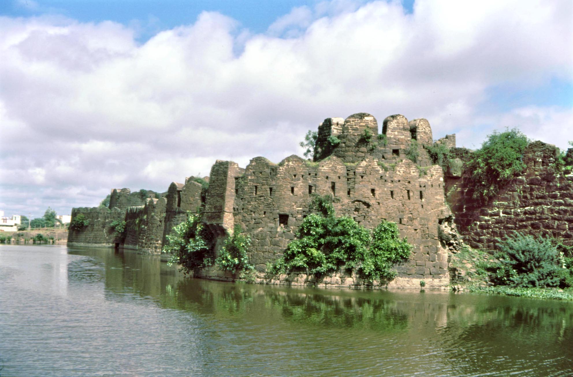 The fortifications of Gulbarga, originally pre-dating
the Bahmani dynasty, but rebuilt and re-enforced
during their reign.
ʿAlaʾ-al-Din made Gulbarga the capital of the Deccan and a flourishing canter of Persian culture. The capital was later moved by Shihab-al-din Ahmad I (r. AH 825-39/AD 1422-36) to Bidar. The tombs of ʿAlâʾ-al-Din and some of his successors, built as domed chambers, are still standing along an avenue in a necropolis just outside the perimeter of the old town walls. The concept of a royal necropolis is unusual in India, as is the curious device of a pair of outspread wings cradling the crescent moon within which is a disc or rosette and which, similar to the Sasanian royal emblem, crowns the arches of these tombs (see Sasanian royal emblems and their re-emergence in the fourteenth-century Deccan, in Muqarnas, XI, 1994). They indicate that ʿAlâʾ-al-Din and his immediate successors had a close knowledge of the pre-Islamic culture and architecture of Persia. They also invented court protocols that alluded to those of the kings in the Shahnama and the Abbasid caliphs. The symbols of royalty included a black parasol and royal curtain, while the throne of Muhammad b. ʿAla al-din, known as the takht-e firuza, was treated like the royal standard of the Sasanians (dirafsh-i Kawiyan). It was studded with jewels added to it by each sultan, to the extent that in later dates its original turquoise enamel over gold casing on ebony could no longer be seen. The various rumours about ʽAla al-din Hasans origins may have been partly responsible for the Bahmani sultans insistence on publicizing their claim to Sasanian lineage by every means at their disposal. The paper includes a full bibliography including works concerned with the obscure origins of the sultan.
* Domestic dwellings in Muslim India: mediaeval house plans, M. and N. H. Shokoohy, BAI, vol. XIV, (2000 nominal, published 2003), pp. 89-110, figs 1-21 (10 architectural drawings, 11 photographs).
ISSN: 0890-4464
Architectural studies on mediaeval India Hindu or Muslim often focus on places of worship, royal palaces, public buildings (such as reservoirs, bath houses and theological colleges) and occasionally military structures. Residential buildings, which are the dominant feature of any built environment and greatly responsible for the characteristics of a town, are usually ignored or noted briefly. A reason is perhaps the modest scale of domestic buildings. Also in most archaeological sites little of the domestic architecture is left and in living mediaeval cities the residential areas have been rebuilt so many times that in most cases even the old urban fabric can no longer be recognised. Nevertheless, in some sites enough survives to provide the grounds for an investigation into the residential sites and a study of the typology of domestic buildings. Close examination of such buildings aims to provide insights into the characteristics and morphology of the towns as well as to understand the relationship between the planning of the public and royal buildings and that of the private houses.
The paper analyses several types of house plans including those with a central courtyard, following a design type probably introduced from the Middle East and Central Asia, and houses planned with a hall and flanking chambers, or with colonnaded porticos, closer to indigenous Indian traditions. Finally the paper considers the fifteenth to seventeenth-century Sufi khanaqahs of Bidar in the Deccan.
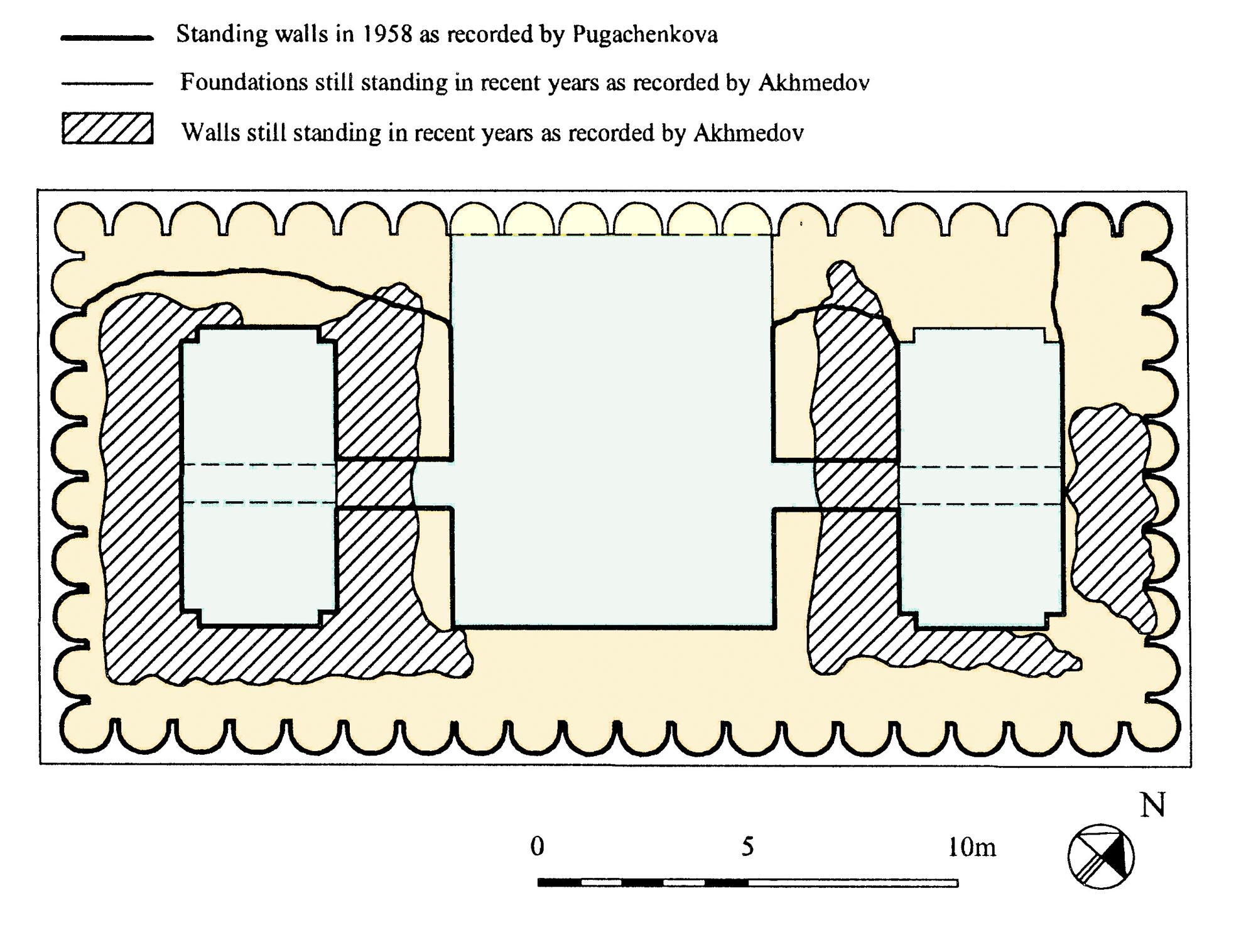
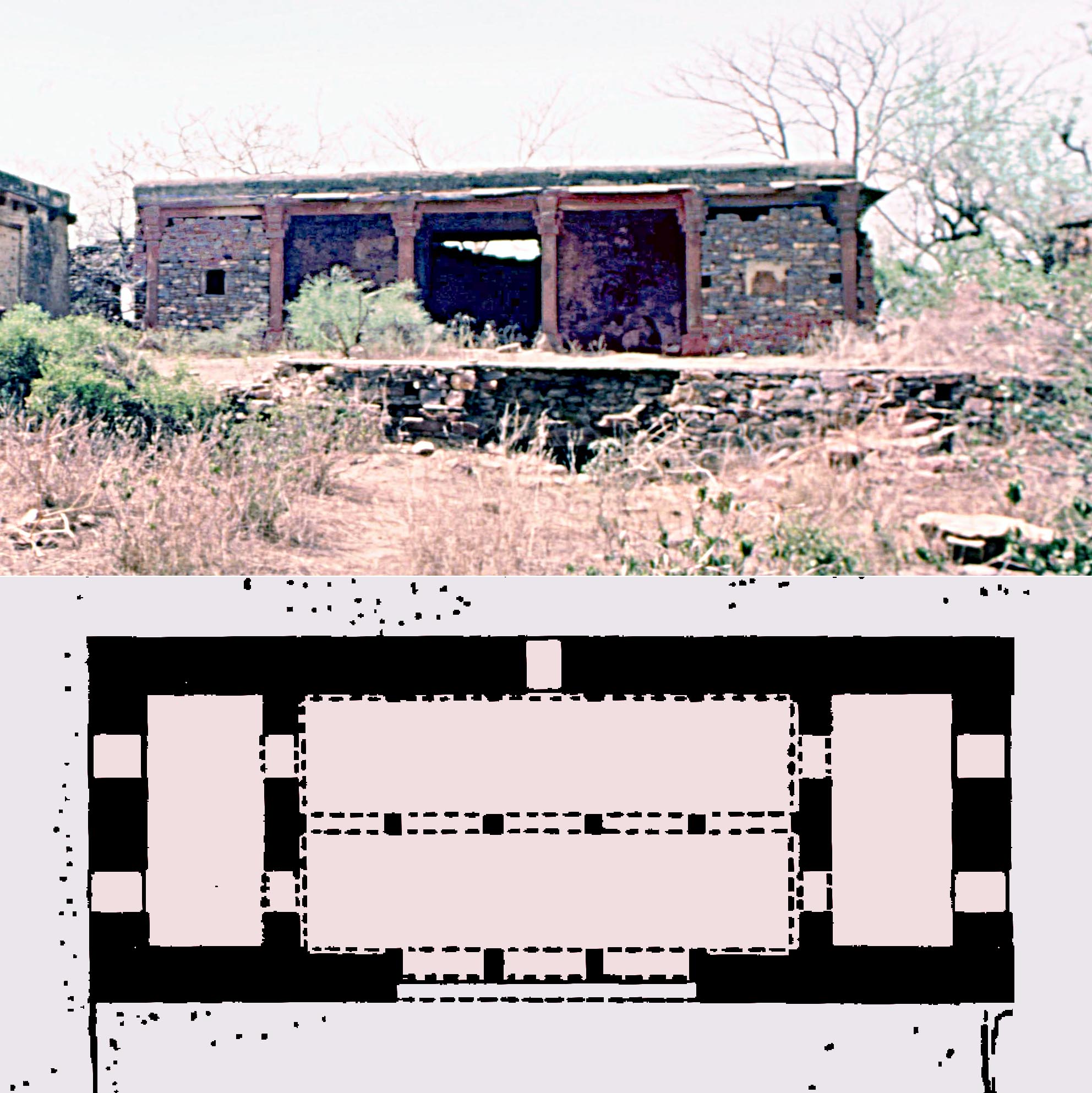
Plan of a tenth century house in Merv with an open hall flanked by two rooms. Such a plan is common in Iran and Central Asia, going back to the pre-Islamic era, although houses with a central courtyard are generally regarded as characteristic of Mediterranean and Islamic residences.
A dwelling with a hall flanked by two rooms, and the
plan of another house with a similar layout, both in the
fort of Bayana, Rajasthan.
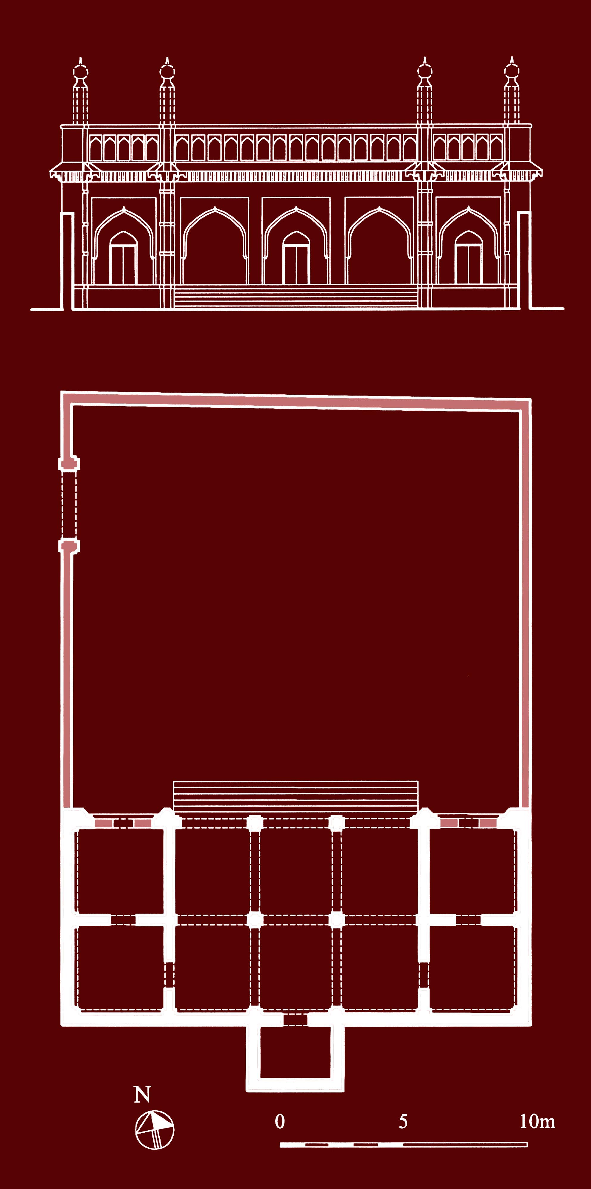 In Bidar, as with all living cities, in spite of the preservation of the old urban layout the houses themselves have been reconstructed several times and the present houses are not particularly old, with the exception of the khanaqahs, preserved because of their religious significance. A khanaqah was traditionally designed on the same lines as a house, to distinguish it from an orthodox religious institution such as a mosque or madrasa (theological college). Almost all the khanaqahs follow the layout of the plan type under consideration and their north-south orientation also follows that of the houses. The choice of orientation also has a wider significance, as by avoiding an orientation towards the qibla (direction of Mecca) the khanaqahs demonstrated their independence from the conventions of orthodox Islam, although the Sufi shaikhs and their disciples in India did observe their Islamic prayers and other religious duties. The plan of the khanaqahs of Bidar follows the concept of house plans with a hall and flanking chambers, the ruins of which are found in archaeological sites, but in Bidar the actual structures are fully preserved, providing an impression the appearance of most Indian mediaeval houses, and the way the internal space was used.
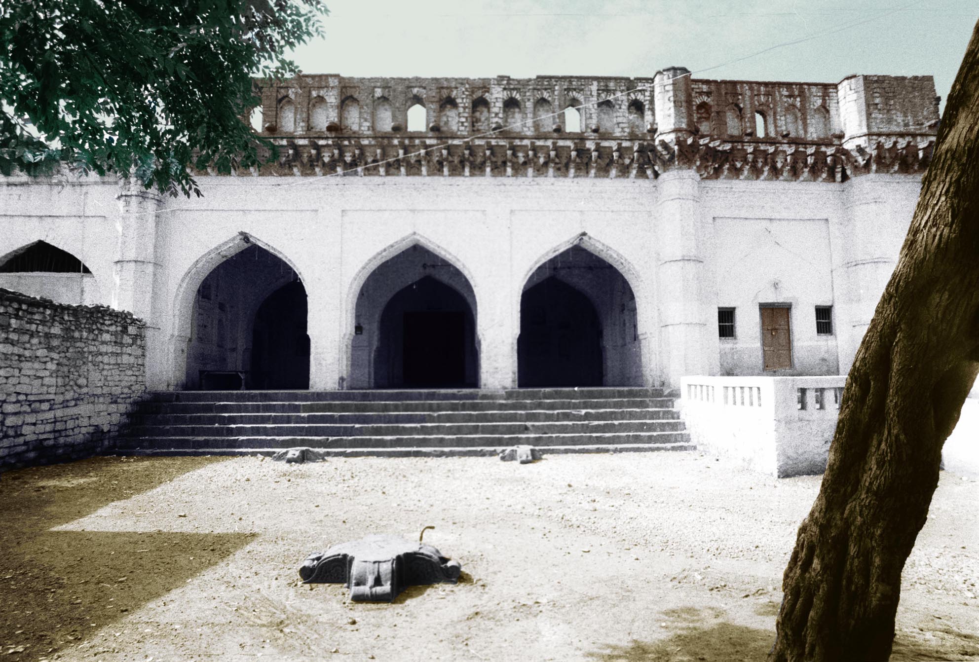
Plan and elevation of the khanaqah of Shah Waliullah at Bidar showing the structure in its original condition.
The Khanaqah of Shah Waliullah has remained without much
alteration, except that the courtyard has been walled off,
separating one of the chambers flanking the central hall from
the rest of the building.
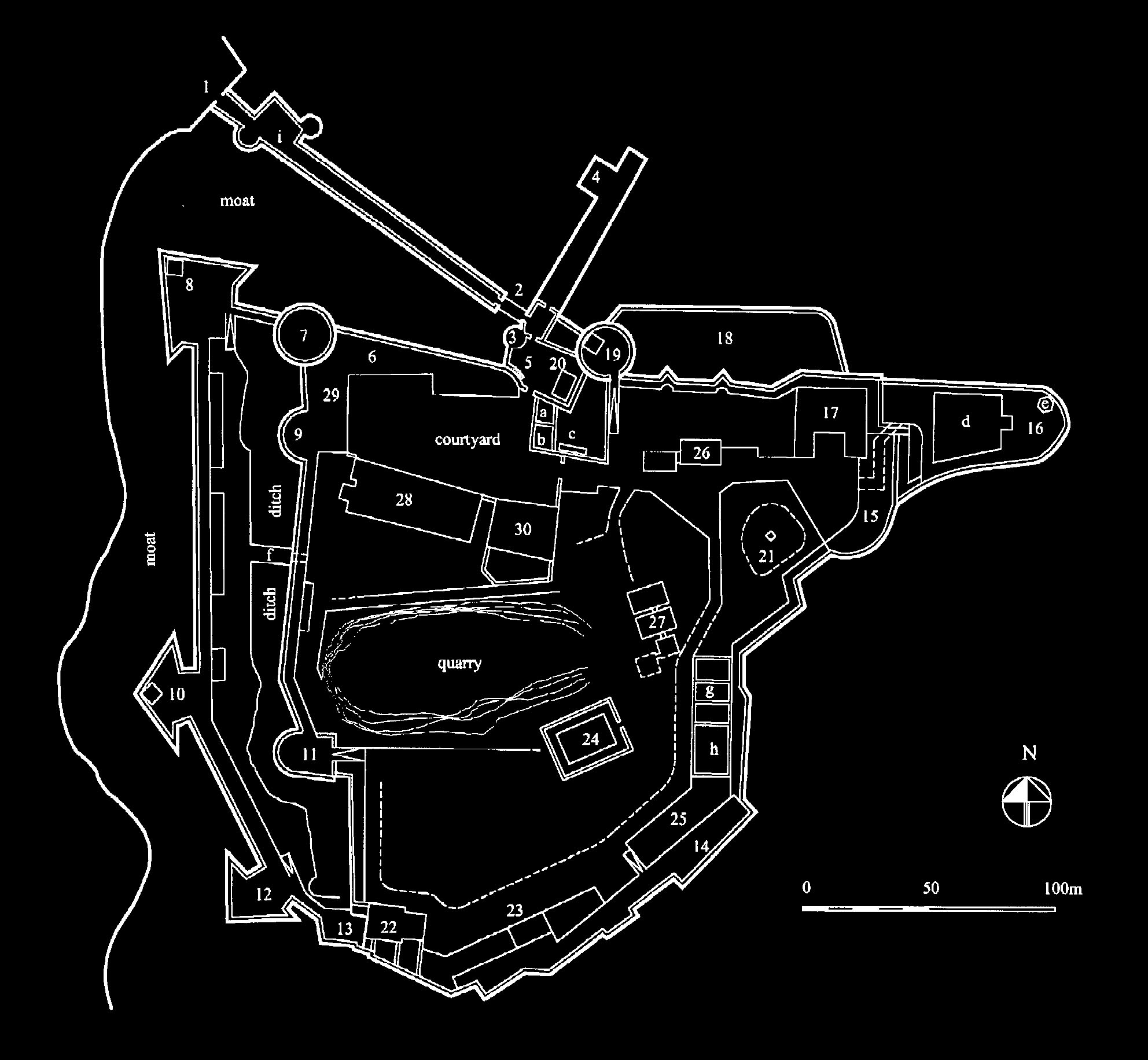 * The Portuguese Fort of Diu M. and N. H. Shokoohy, SAS, vol. XIX, 2003, pp. 169-203, figs 1-47 (4 old engravings, 4 maps, 7 architectural drawings, 32 photographs).
ISSN 0266-6030
Throughout the long history of the Indian Ocean trade the island of Diu, off the western coast of Saurashtra, was regarded as a sizeable trading port, although it was and still is relatively far from the capital and other populous towns of Gujarat. Diu was, however, situated strategically at the mouth of the Gulf of Cambay and could control the maritime traffic to the heart of Gujarat. To construct the fort at Diu in 1534 was a triumph for the Portuguese, achieved after a long and frustrating struggle, in many respects more ponderous than the take-over of Goa. The fort and Portuguese town still stand with little alteration and although many buildings in the fort have been reconstructed the fortification walls and some old structures have survived.
Plan of the fort of Diu.
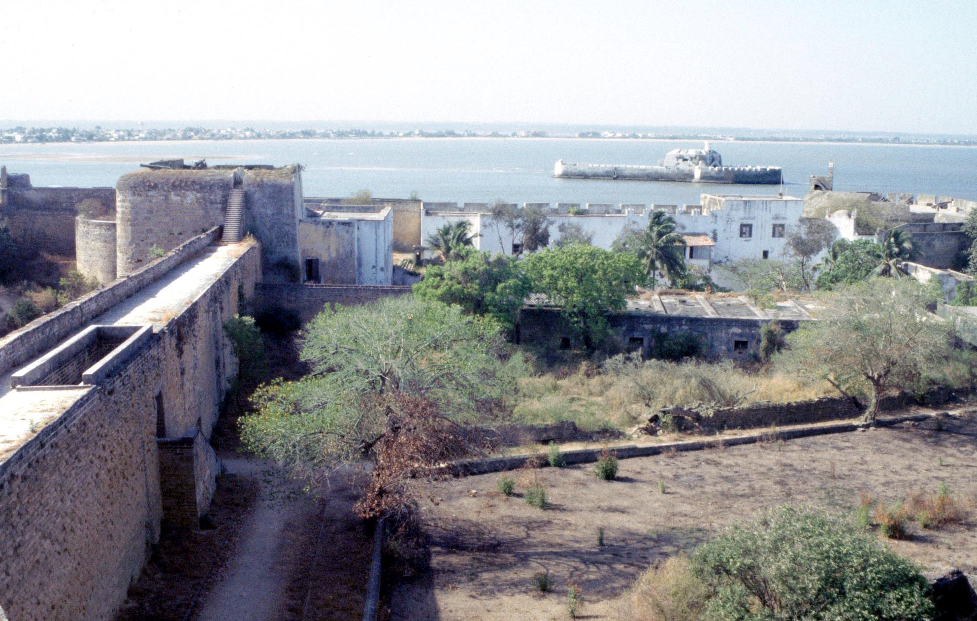 Between the fort and the mainland is a small fortification
in the middle of water, known to the Portuguese as Forte
do Mar (Sea Fort) and to Indians as Panikotha (Water Fort),
its origins going back to the pre-Portuguese era, when it was
a simple tower controlling a chain which could bar ships from
entering the harbour.
Here we present a report of the survey of the fort and its monuments supported by measured drawings and photographs. The original arrangement of the fort and modifications made over the centuries are analysed, based on the historical accounts, early sketches and plans from the sixteenth to the nineteenth century, surviving inscriptions and published records of epigraphs removed following the return of the island to India in 1961. The bastions are each named after a saint and vary in form as the technology of defence developed. The towers still preserve examples of cast bronze cannons, one dated 1624, and one made of laminated steel straps. The role of the jetties and the fortified tower between the mainland and the fort is discussed, along with the system of stretching chains across the harbour to control shipping, a method inherited from Muslim times.
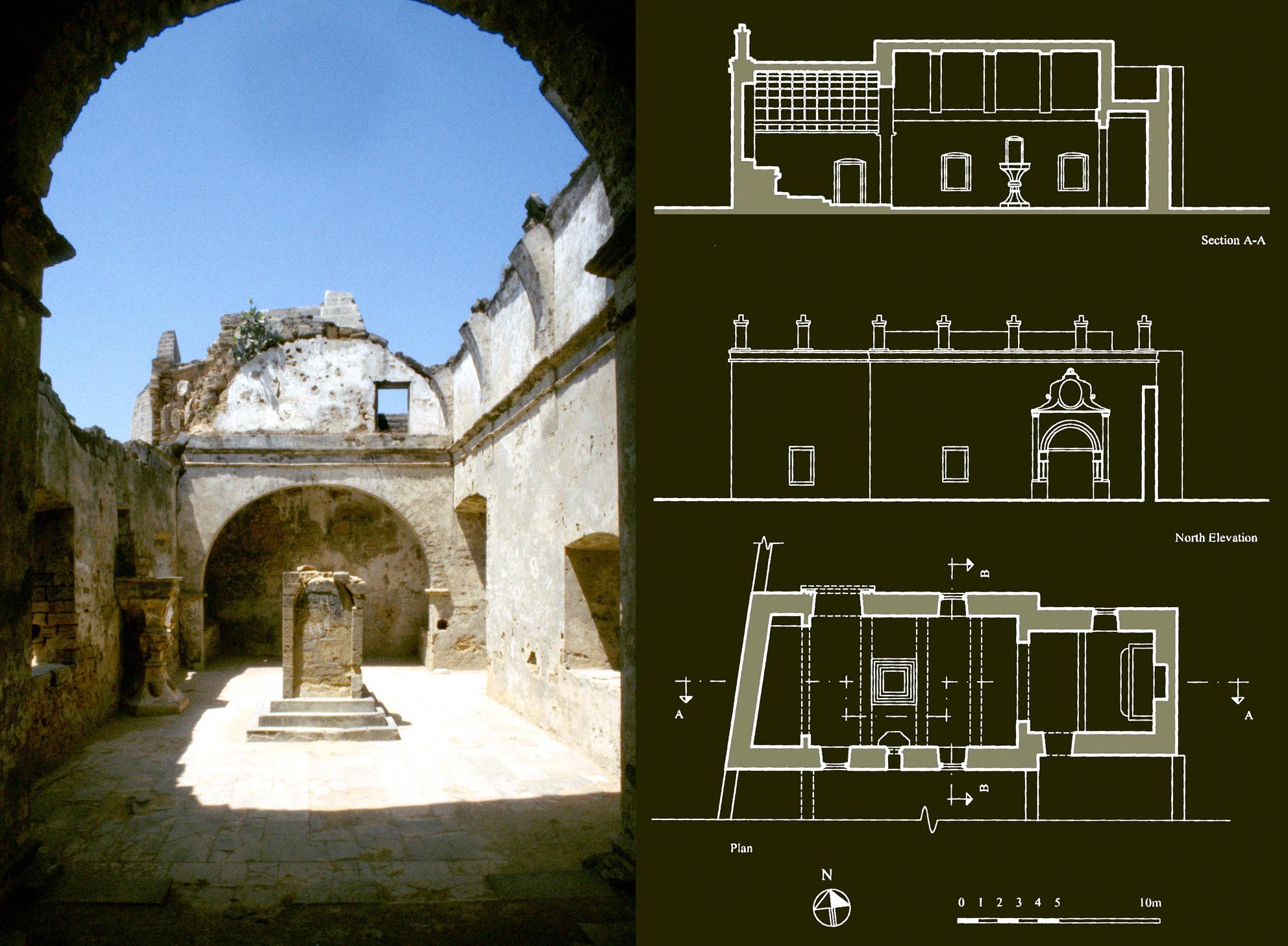 Fresh water was a major concern, as well water would be brackish. In Diu various systems were employed, including that used by the Portuguese for Hurmuz in the Persian Gulf, whereby the roofs, the banquettes and other paved areas slope towards channels and drainage holes opening to large covered stone reservoirs both above ground and underground. An open tank of the Indian type was also built in a fortified breastwork. The standing buildings include the old Governors Residence, a powder magazine resembling a chapel, utility rooms, a misericorde, and St Jamess Chapel (at one time used as a wine store) with its chalice-shaped pulpit, probably one of the oldest buildings in the fort. The buildings display a combination of local and Portuguese styles of design, construction and decoration.
Sao Thiago (St James) Chapel in the fort. Many times restored and partly demolished by the Indian navy in 1961, it preserves its original layout. It was built soon after the construction of the fort, making it one of the earliest churches in Diu.
* A history of Bayana Part 1: from the Muslim conquest to the end of the Tughluq period, M. and N. H. Shokoohy, The Medieval History Journal, vol. VII, part ii, 2004, pp. 279324, figs 1-6 (2 maps, 4 photographs), appendix.
ISSN: 0971-9458
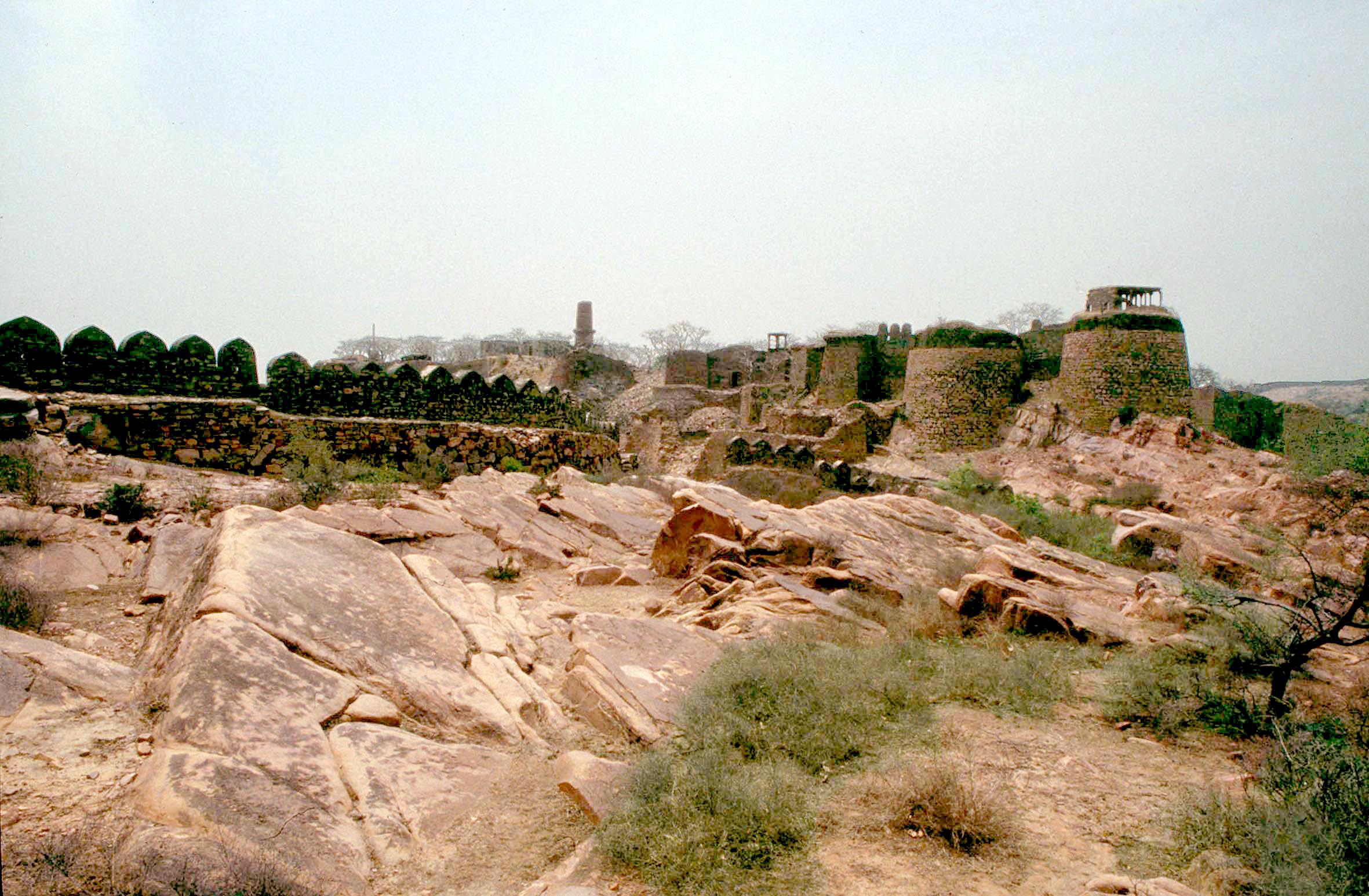 For the sultans of Delhi control of Bayana in eastern Rajasthan was a key to securing their southern territories from the local Hindu rajas, in particular of Gwalior, not far south of Bayana. It was one of the first areas to be taken over by the commanders of Muhammad ibn Sam, but local sayings allude to Mahmud of Ghazna attacking its mighty fort almost two centuries earlier. The first part of the study sets out the history from the inscriptional evidence, the standing monuments, and the contemporary sources including al-Utbi, Barni, Minhaj-i Siraj, Shams-i Siraj, Yahya ibn Ahmad, Abul Fadl, and Ibn Battuta.
The work looks beyond the fort and town and establishes the boundaries of the region, its resources and the ethnic origins of its Muslim population. Extracts from the histories are given in their original Arabic and Persian, along with fresh translations. The two parts of the study, totalling 113 pages, provide a comprehensive history of the region from scattered nuggets of source material.
The citadel of Bayana, of pre-Islamic origin but taken over by the
Ghurid army at the end of twelfth century and preserving monuments
from the early thirteenth to the eighteenth century, when the fort and
the citadel were finally abandoned.
* A history of Bayana Part 2: from the rise of the Auhadis to the early Mughal period (fifteenth seventeenth centuries), M. and N. H. Shokoohy, The Medieval History Journal, vol. VIII, part ii, 2005, pp. 323400, figs 1-12 (1 map, 11 photographs) 2 appendices.
ISSN: 0971-9458
The second part of the study discusses the changing role of the town and its region in south-east Rajasthan, from the time following Timurs invasion, when the fragmentation of the power of the Delhi sultanate allowed the Auhadis the local rulers of Bayana to assert their independence. Under the Lodis the Jalwanis, another dynasty, rose briefly to prominence, but was soon removed from the scene by Sikandar Lodi. Although chosen initially by Sikandar Lodi as his capital, Bayana was gradually eclipsed by his later decision to establish the capital in one of Bayanas villages, near a major river and better situated: at Agra.
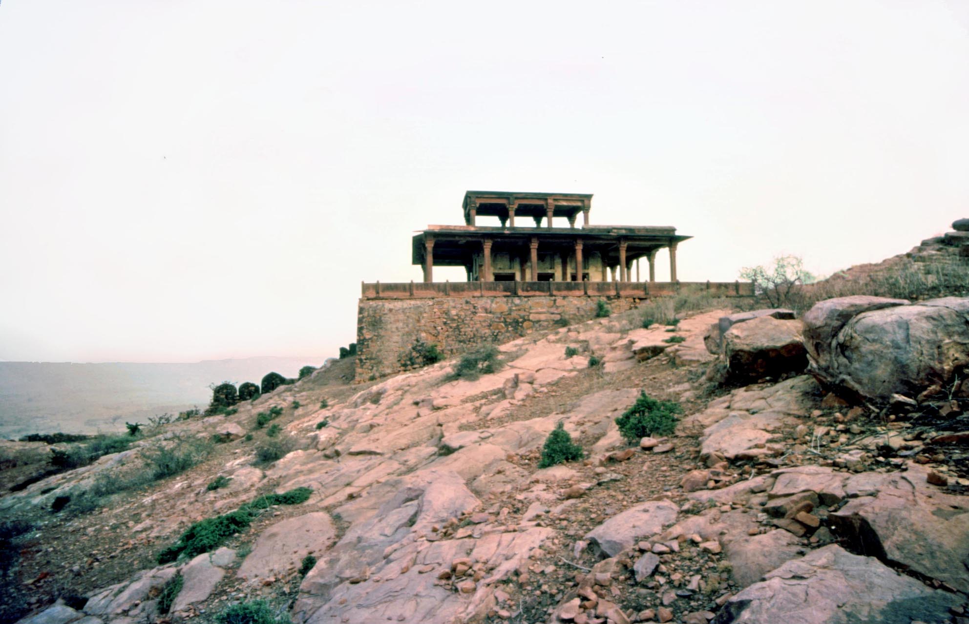
The ʽImarat-i badgir (the airy edifice), built at the time of the Mughal Emperor Humayun is a predecessor of the buildings of Akbar at Agra and Fathpur Sikri. The Emperor Jahangir said of the ʽImarat-i Badgir: It looks over the fields, built on a high position, and has pleasant breezes.
Bayanas lack of water, its devastation after an earthquake in 1505, and the migration of the population to the new capital all contributed to the decline of Bayana under the Mughals and Suris, but at the time of Islam Shah the appearance of a Mahdi made it the scene of religious and social upheaval. Under Akbar Bayana became a district of the province of Agra and by the time of Jahangir the town was no longer an active urban centre, but in architecture the characteristic style developed in Bayana became a hall-mark of that of the early Mughals, and it is in this resonance that we see how the culture of Bayana shifted geographically, but did not die out.
As with Part 1, an appendix concerning the historical inscriptions found in the town and region of Bayana is given. The texts of the inscriptions given in Part 2 are instrumental for understanding the affairs of the otherwise little-known Auhadi dynasty.
* The Chatri in Indian Architecture, Persian wooden canopies materialised in stone, M. and N. H. Shokoohy, BAI, vol. XV, 2001 (published 2005), pp. 129150, figs 1-26 (11 architectural drawings, 22 photographs).
ISSN: 0890-4464
The chatri, a type of trabeated domed canopy, is one of the most common building forms in traditional northern and western Indian architecture. The feature is so widespread that its presence is taken for granted and its origins and development have never been seriously examined. The term derives from the Persian chatr (Sanskrit chattra) meaning an umbrella or parasol: an archetypal symbol of the vault of heaven and thus sacred or secular supremacy and protection. Chatri, meaning therefore a parasol-like building, refers to any freestanding domed pavilion supported by columns with no walls. Chatris are sometimes funerary pavilions covering tombs, but in association with other buildings they are often positioned on the roofs, mainly as decorative features accentuating the skyline.
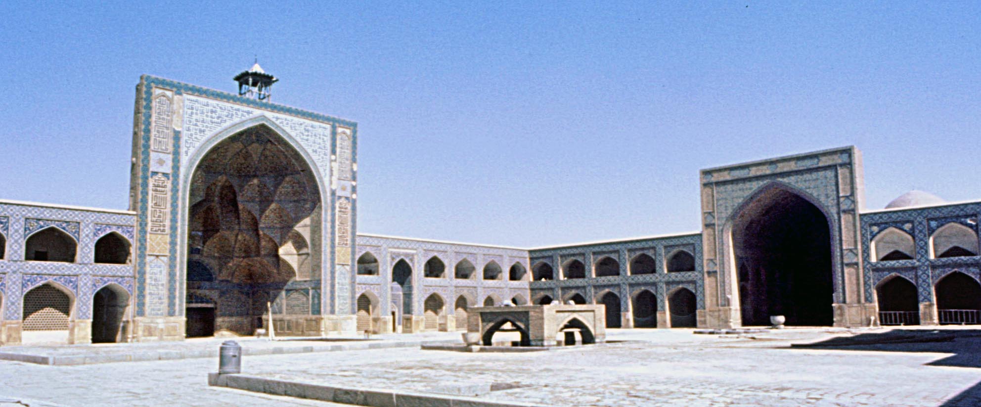 As with this example at the Jamiʽ Mosque of Isfahan, wooden
canopies, once common on every rooftop, still appear on the
highest points of the mosques of Iran.
The Jamiʽ Mosque of ʽAqda, Iran, has a version of the wooden canopies, but built of brick and mortar. Although not common there are other examples of this kind in Iran.
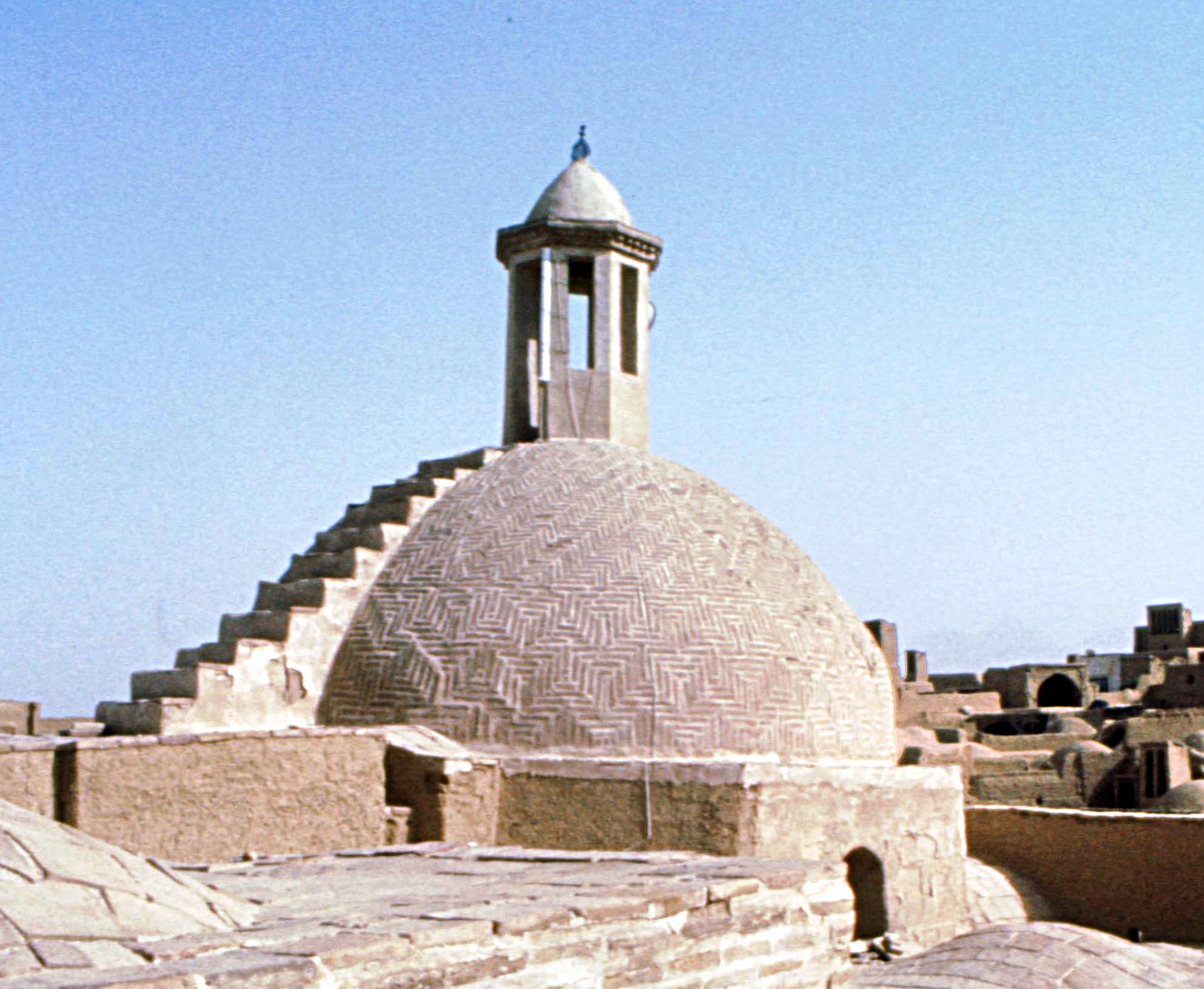
The most basic type consists of a square platform with four columns upon which stands a small dome, while grander forms have a square plan with twelve columns, or are hexagonal or octagonal in plan with six or eight columns. The paper explores the origin of the form in Persian architecture and demonstrates that not only the concept of building a funerary monument over a grave in India where the dead were cremated was a Muslim import, but the concept is also Persian, although in Iran and central Asia they are usually constructed of timber.
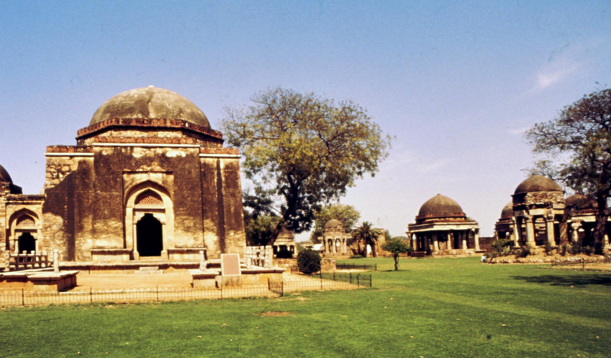
In India wooden canopies existed until the early fourteenth
century, when the chatri, the stone version of the form,
became increasingly popular. Some fourteenth century and
later examples appear next to the tomb of Firuz Shah Tughluq
(r. 1351-88 AD) at Delhi.
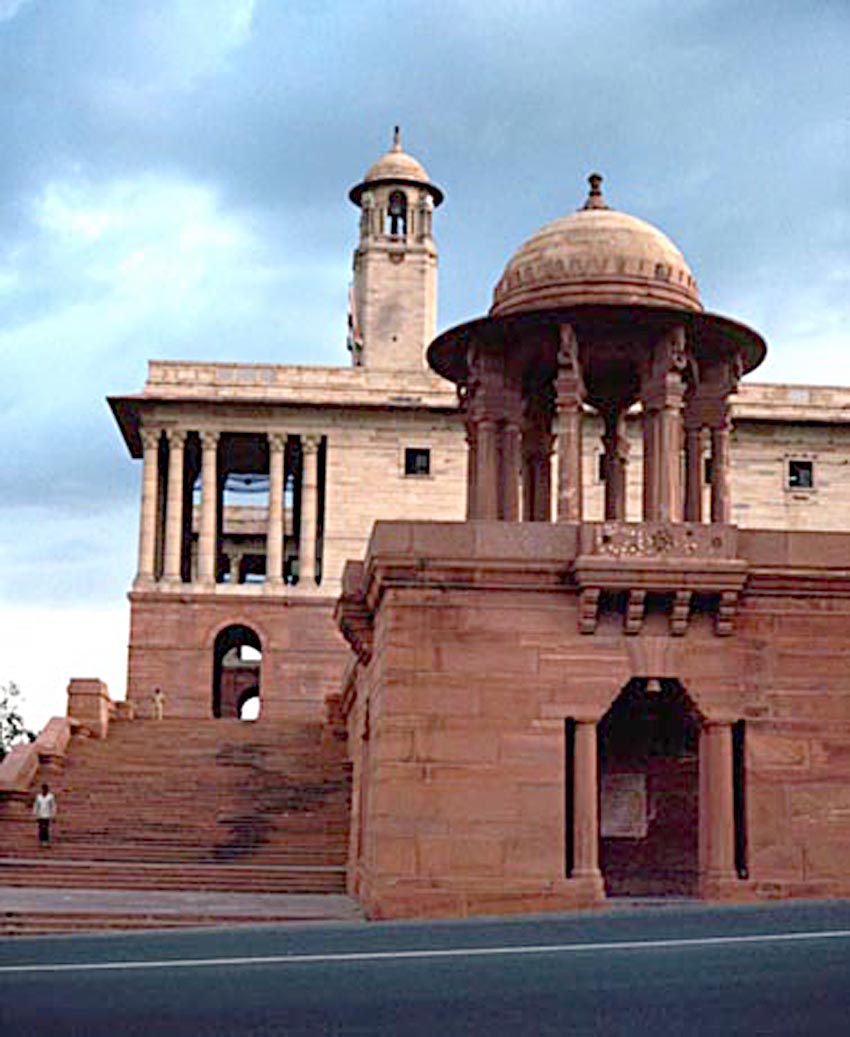 Numerous examples are given of the existing features in Iran and evidence of their earlier origin is presented through Persian miniatures. The paper also explores Indian historical sources and concludes that the early examples of the thirteenth and early fourteenth century Indian sultanates, chatris, then known with their Persian name khargah or khuramgah, were also constructed of timber, but from the early days of the Delhi sultanate examples in stone were also tried out.
From the fourteenth century the chatri has been an integral part of both Muslim and Hindu architecture in India, adorning most significant buildings. At New Delhi chatris define the skyline of the architecture of Lutyens and Baker.
* The town of Diu, its churches, monasteries and other historic features, M. and N. H. Shokoohy, SAS, vol. XXIII, 2007 (published February 2008), pp. 141-188, figs. 1-65 (4 old engravings, 1 map, 5 urban plans, 27 architectural drawings, 49 photographs).
ISSN 0266-6030
The island of Diu, off the coast of Gujarat, was a prized Portuguese possession, which, unlike other colonies often taken over swiftly with little local resistance, fell into Portuguese hands through an unexpected opportunity after many years of fruitless struggle with the formidable sultanate of Gujarat. The advance of the newly arrived Mughal forces in India on Gujarat led Bahadur Shah to judge that by granting the Portuguese permission to build a fort at Diu he might achieve an ally for the survival of his kingdom. A fort was swiftly erected after the signing of a treaty on 21st September 1534, a decision he was to regret, and which eventually cost him his life.
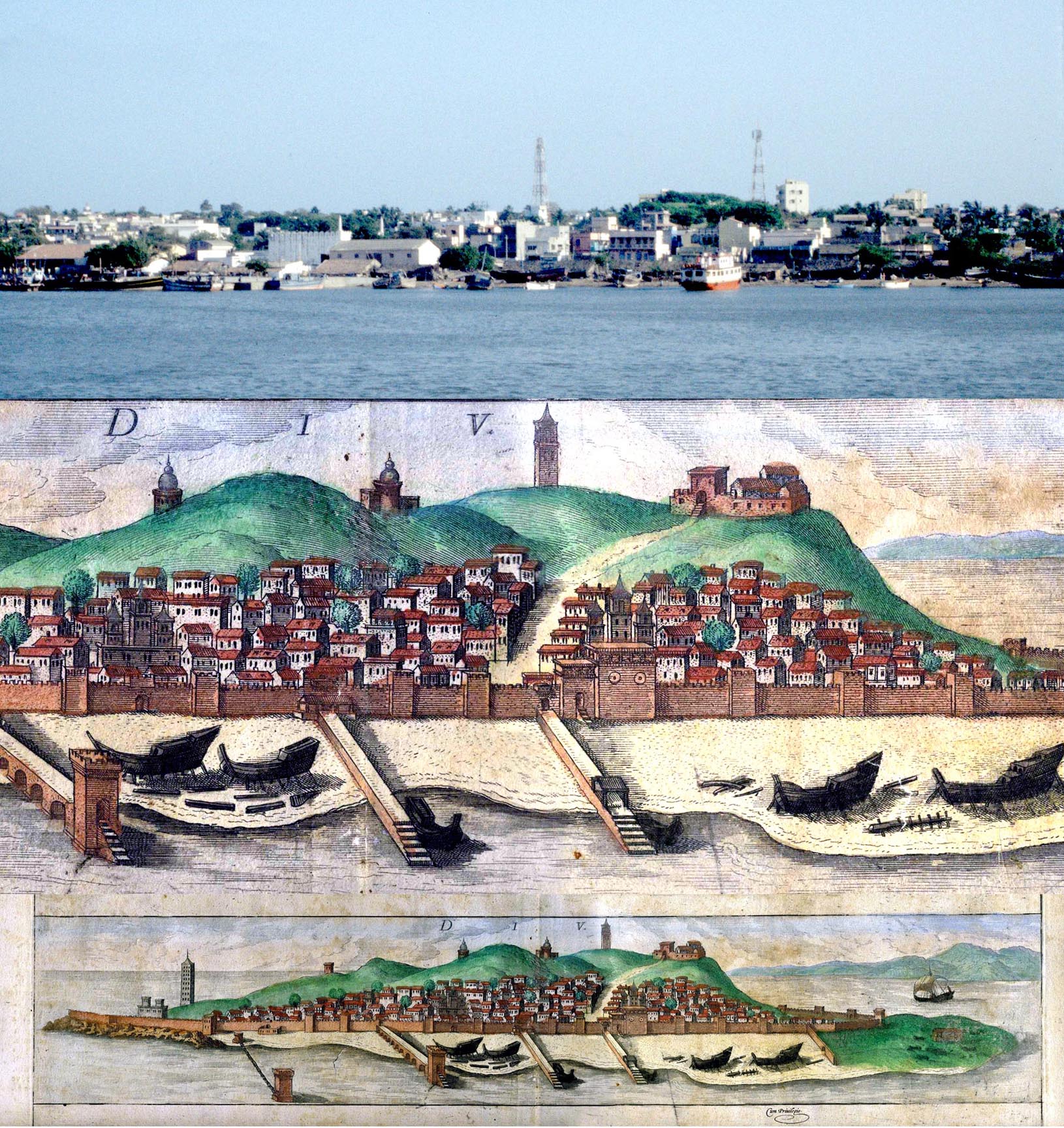 Before the arrival of the Portuguese, Diu was a thriving Muslim port of the Indian Ocean maritime trade and was occupied by traders of many nations: Arabs, Turks, and Persians. The Portuguese were first confined to their fort but with the fall of the Gujarat sultanate they eventually took over the town and the island. To the Mughals, who benefited from Portuguese trade and tribute, re-taking this small island was irrelevant. The town of Diu was gradually rebuilt on Portuguese colonial lines, and its layout survives, along with the town walls erected between 1517 and 1584, and many monuments. These include an old cathedral founded in 1536 and reconstructed in 1598 (now converted to a museum); the church and convent of St. Francis of Assisi built in 1593; and the church and convent of St. Paul, originally a Jesuit seminary founded in 1601 with the church now serving as the cathedral of Diu and the seminary as a school. Among many other edifices are a chapel and a number of Christian shrines as well as civic and administrative buildings, a market and market square, and a number of civic monuments.
An old engraving of the Diu town before the construction of the Portuguese
fort, and a modern view of the town from a similar position across the water
from the mainland. To the right of the engraving the sultans governors
mansion is shown over a hill with a road leading to a public square in front of
a mosque. Most of the old pre-Portuguese layout has survived, including the
platform of the mansion, which can be seen as a mound in the modern view.
 Nevertheless, the pre-Portuguese Diu is not entirely lost. Before the appearance of the Muslims Diu had been rich in Hindu and Jain temples, none of which survive, but finely carved architectural fragments are found all over the island. Some Muslim edifices still stand including the Karao Jami, the early congregational mosque built of temple spoil and apparently dating from the time of Alâ al-dîn Khaljî (r. AD 1296-1316), who annexed Gujarat to the Delhi Sultanate, and a later mosque, known as the Caravan Masjid, which seems to have been founded in the early sixteenth century, but was reconstructed subsequently. Although the town was remodelled by the Portuguese, features of the layout of the Muslim town remain, along with the site of the Muslim citadel and parts of its ramparts.
The paper is the third interim report of our project of the survey of Diu and apart from exploring the history gives a nineteenth century town plan with a freshly produced one, marking all the monuments and other edifices. Descriptions, photographs and measured drawings are given of the remains of the pre-Portuguese town and its governors mansion, the Caravan mosque, the Portuguese town wall and gates, the waterfront, the Sea Gate, St. Thomass Church, St. Franciscos church and monastery (now hospital), St. Pauls cathedral and seminary, St Annes Chapel and three street shrines. The morphology of the town and some of the old houses are also discussed.
St Pauls Church and seminary, designed by a Jesuit priest, Father Gaspar Soares da Companhia de Jesus. Its first stone was laid in 1610 by the governor, Duarte de Mello together with Father Vigario da Vara Manoel Fernandes, and was completed in 1612. The church has been designated as the cathedral of Diu since 1834 when the old cathedral of St Thomas was deconsecrated. The seminary is now a school.
* Waterworks of Mediaeval Bayana, Rajasthan N. H. Shokoohy, BAI, vol. XVIII, 2004 (published 2008), 19-42, figs. 1-17 (1 map, 10 architectural drawings, 12 photographs).
ISSN: 0890-4464
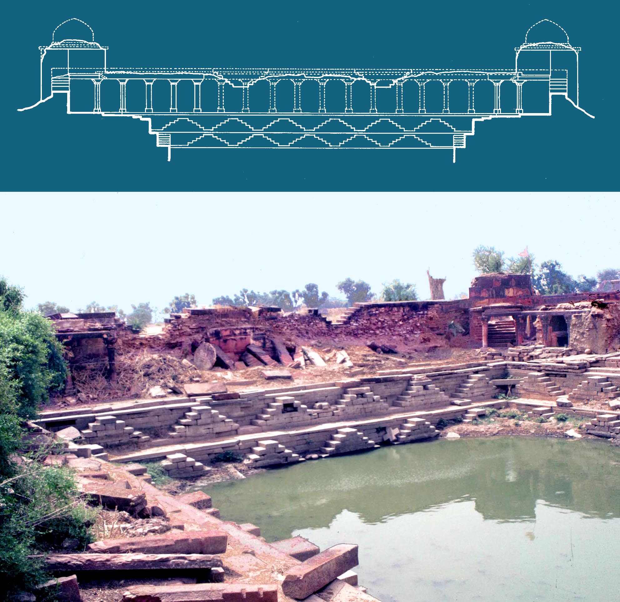 Bayana, if it were not for its harsh climate, could have been the capital of the Delhi Sultanate. While not far from Delhi, from the very beginning of the Islamic conquest many of its rulers found themselves strong enough to claim independence. But to make the region viable the had to employ all the main systems for managing water known in India while other areas with different climatic conditions would have utilised only some of the repertoire of traditional methods.
One of the oldest dated reservoirs built in India under Muslim patronage, the early fourteenth-century Jhalar Baoli, is in Bayana. Furthermore a distinctive style of architecture which developed in Bayana in the fifteenth and sixteenth centuries was later to be employed in the Imperial buildings of Mughal India, a striking precursor of which appears in the Baoli of Khan-Khanan, a step-well in the fort of Bayana dating a century before the time of Akbar, but employing structural details usually considered to have been innovations of his time. Bayanas waterworks like other aspects of this historic place have not, however, been given the scholarly attention that would be expected.
The grand reservoir known as Jhalar Baoli with four domed entrances and a colonnade, now in ruins. Sets of steps give access to the water level at any time of the year during the monsoon water is at the level of the colonnade while in the dry season it is as low as in the photograph. The reservoir was built in 1318-19 of the local red sandstone, famous in India and still exported all over the country for cladding modern buildings.
New surveys together with measured drawings document the historic step-wells, reservoirs, dams and wells with analysis of the epigraphs and contemporary accounts highlighting the social prestige associated with creating infrastructure for managing water far beyond utilitarian considerations. The paper also demonstrates how, at the time of the Mughals, when Bayana began to decline, its architecture was simply transferred to the new towns in its territory: Agra and Fathpur Sikri. Here, for the first time the riches of a great empire, beyond the imagination of any Bayana ruler, showed the heights that the local architectural traditions could achieve.
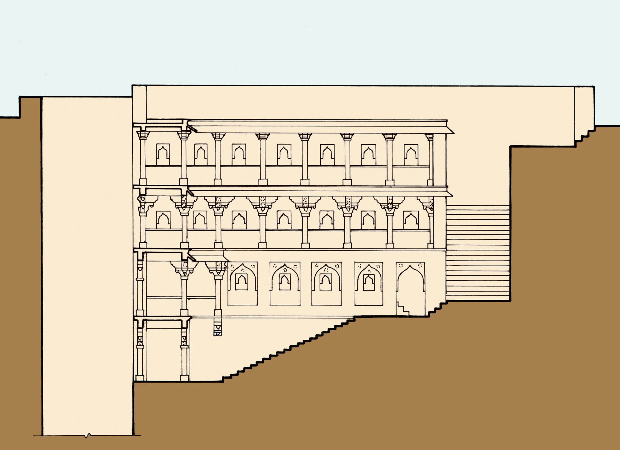
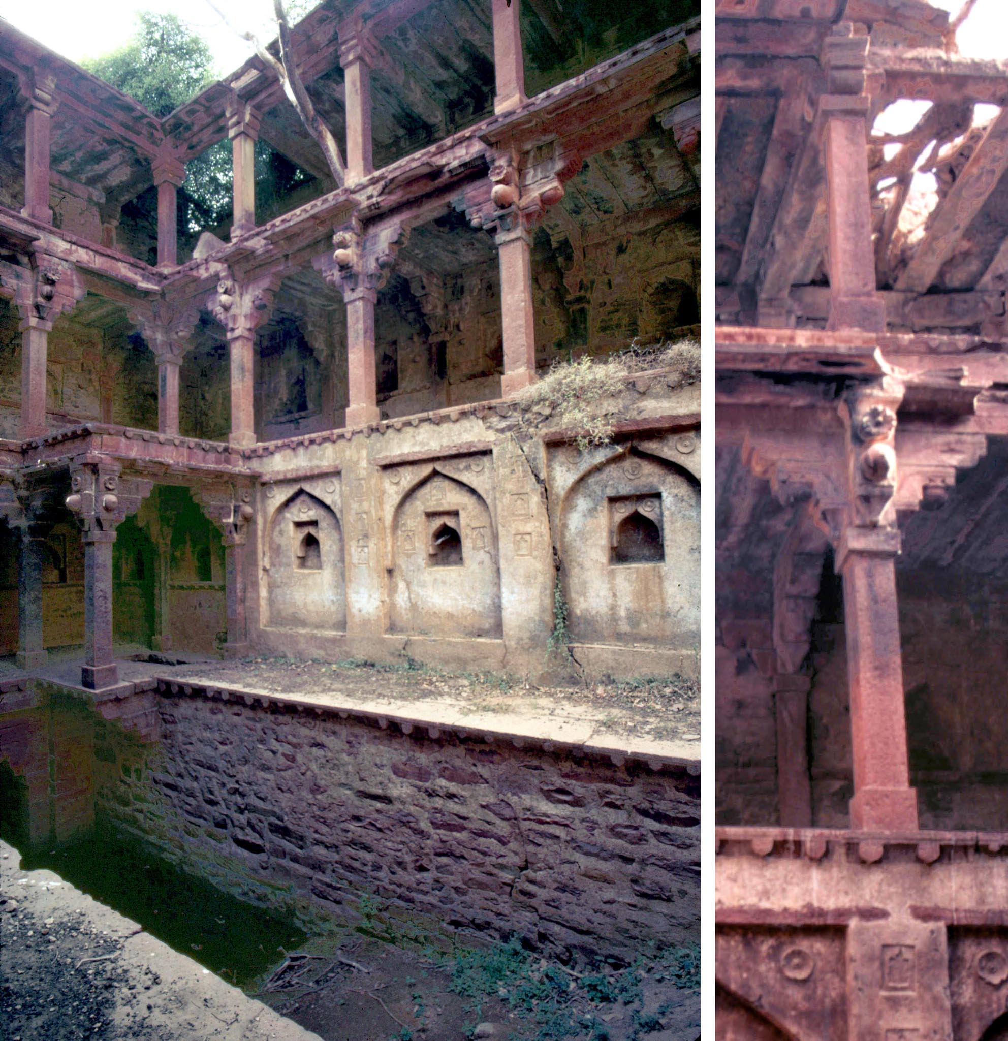
The Baoli of Khan-i Khanan Farmoli has the general
configuration of step-wells common in north and west
India, with a well at one side and a set of steps at the
other descending to the water level. The colonnades
provided a cool retreat from the desert climate.
The Baoli of Khan-i Khanan, built in 1497, displays fine carvings in the style associated with seventeenth century Mughal buildings, but is over a hundred years earlier, displaying the advanced state of Bayanas architecture, which had developed independently from that of Delhi and other regions.
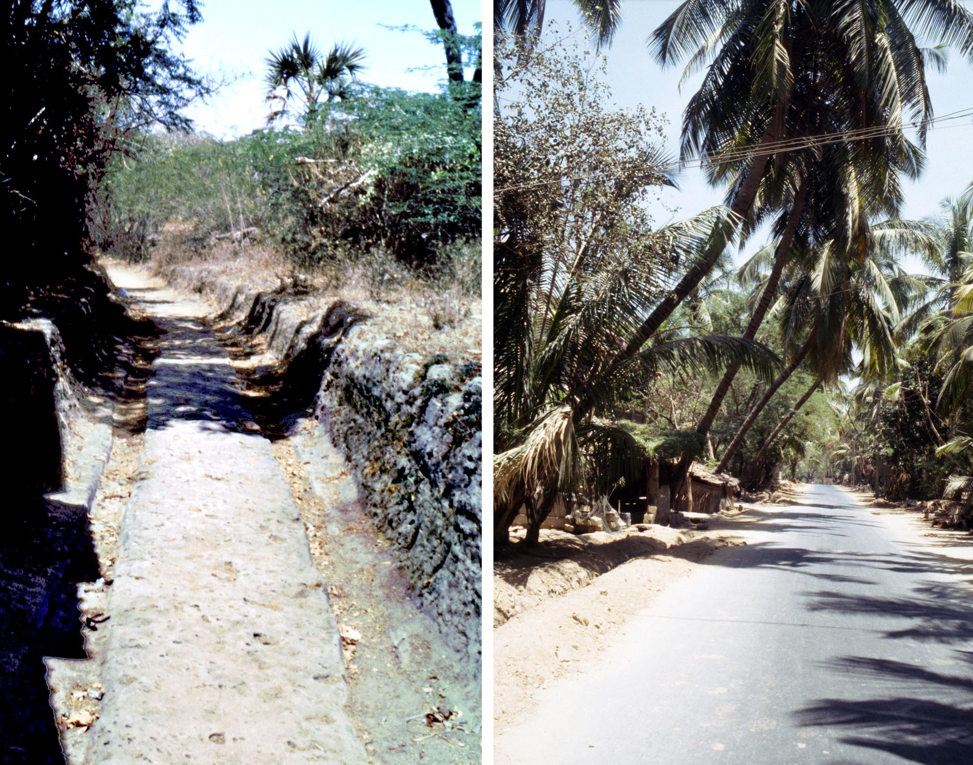 * The island of Diu, its architecture and historic remains, M. and N. H. Shokoohy, SAS, vol. XXVI, 2010, 161-190, figs 1-40 (1 map, 1 site plan, 2 town plans, 24 architectural drawings, 33 photographs).
An ancient track and a modern road connecting the town
at the east end to the inland villages and the fishing port
of Vanakbara at the western extremity of the island. Wheel-
tracks cut in the rock still remain in parts of the old road.
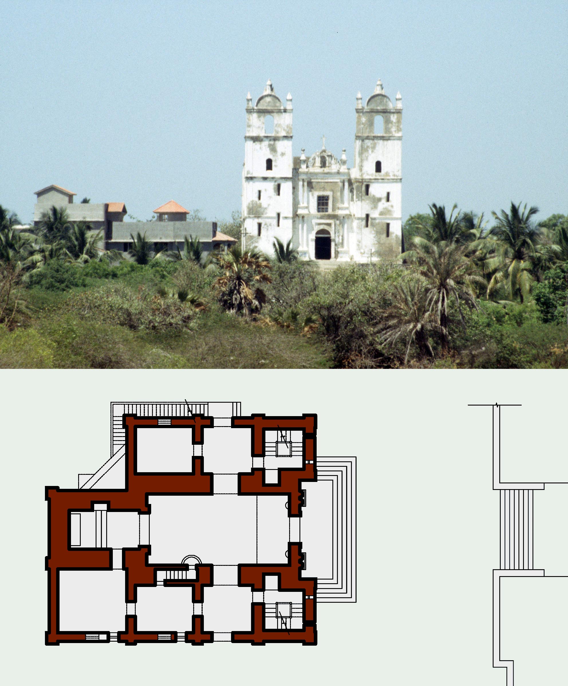 Diu, unlike many ex-Portuguese colonies in India, preserves a variety of cultural and historical edifices of many communities. While impressive churches create landmarks and Portuguese houses give the narrow lanes and urban and village squares a Mediterranean flavour, the legacies of Hindus, Muslims and Zoroastrians are also evident in the island and are explored as part of the ongoing research on the diverse culture of Diu from the thirteenth century to the present
Starting with the pre-Portuguese Muslim remains on the coast near the town we then trace the ancient road with wheel-marks engraved in the rock leading to Fudam, where stands the church of Our Lady of Remedies. In Fudams vicinity near the coast is the Gangeshvara rock-temple dedicated to Shiva and near the temple are other Hindu remains and the two Zoroastrian Towers of Silence (dakhma), one of which is well preserved and provides an unprecedented opportunity to study its design and construction. Further west takes us to the shrine of Pir Habash Baba, (the name indicates Abyssinian origin) revered by Muslims. Finally, at the west of the island the fishing village of Vanakbara is explored, with its shady urban square, the Jamaat khana (mosque) of the Khoja Ismilis and the Church of Our Lady of Mercy.
The small Church of Our Lady of Remedies, built in 1667 on a high platform at Fudam, is visible from a distance, towering over the surrounding buildings and trees. The roof, accessed by stairs in the bell-towers, gives panoramic views over the island.
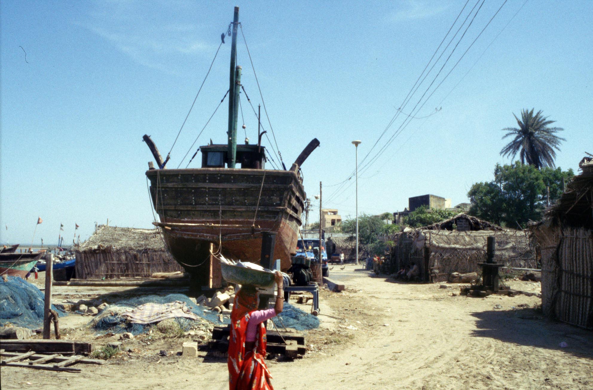
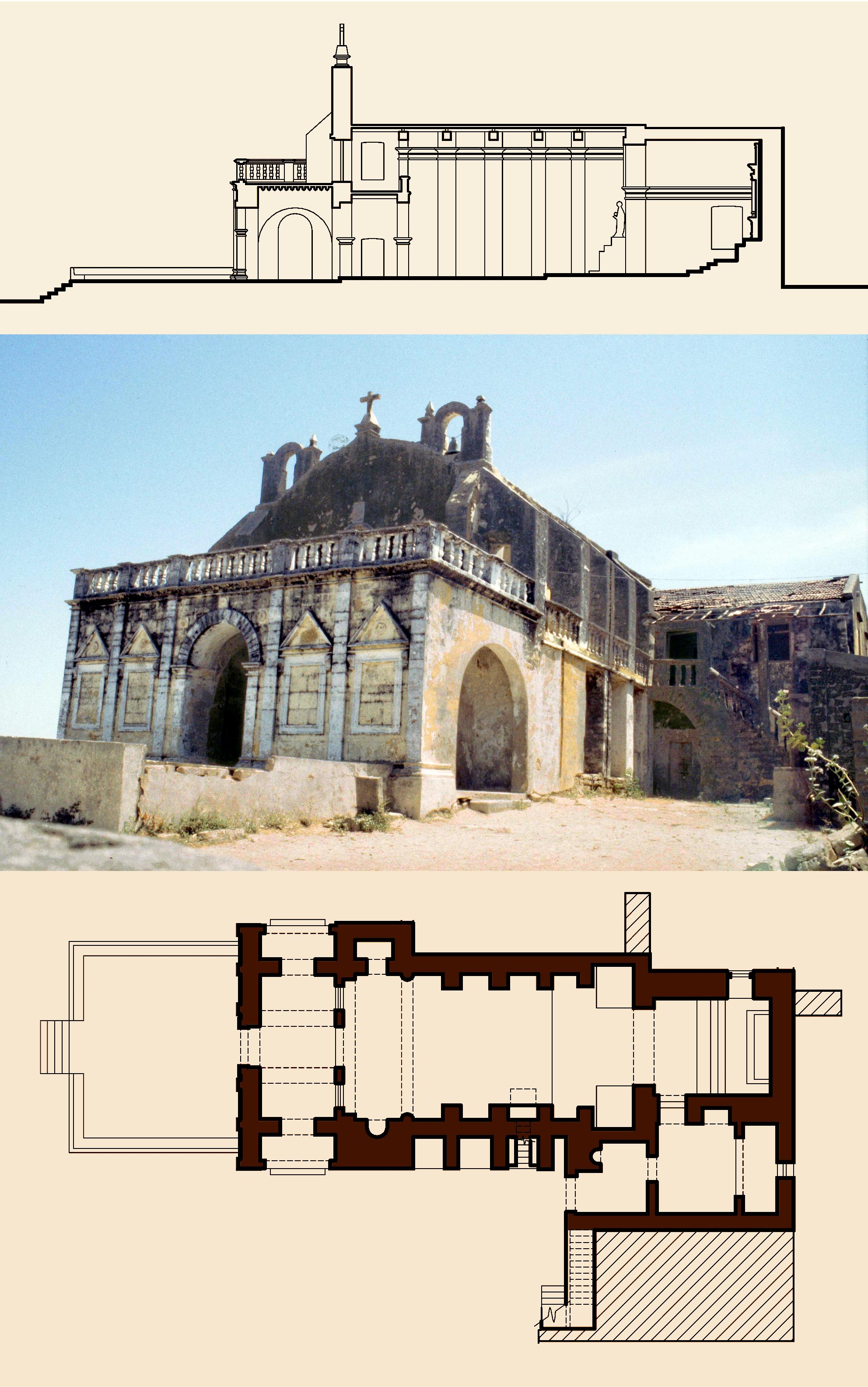
Vanakbaras fishing port is still a centre for repairing
and building sea-worthy vessels in the style of the
Arab ships that plied the Indian Ocean centuries before
the appearance of the Portuguese.
The Church of Our Lady of Mercy, built in Vanakbara in 1616, differs in structure from other churches of the island as it has a timber rather than a vaulted ceiling. It is also notable for the pseudo neoclassical elevation and external access to the upper gallery.
The fourth preliminary report of the Survey of Diu includes a map of the island and town plans of Fudam and Vanakbara as well as measured drawings of the churches in these locations, two pre-Portuguese mosques, the shrine of Pir Habash and a number of other buildings. The Towers of Silence are noted, but these are studied separately in The Zoroastrian Towers of Silence in the ex-Portuguese colony of Diu, BAI, vol. XXI.
The legacy of the Parsi community of Diu, M. Shokoohy, Hamazor, Publication of the Wold Zoroastrian Organization, vol. LV, ii, 2010, 75-81, figs 1-12 (7 architectural drawings, 9 photographs).
The first appearance of the Zoroastrians in Diu goes back to the early days of their migration to India. The Qissa-yi Sanjan ("the tale of Sanjan"), a poetic composition of the time of the Emperor Akbar narrating an oral history of the migration mentions that after the Muslim conquest of Iran the Zoroastrians dispersed in the mountains for a century before abandoning their homeland. Some then took the maritime route to India, landing in Diu and nineteen years later left Diu for Sanjan, where the local raja granted them permission to settle; many more joined them and the sacred Fire of Varhram was lit. It therefore seems that the community in Diu was established sometime later and according to local records in Diu the Zoroastrian view is that they resided on the island for over four centuries.
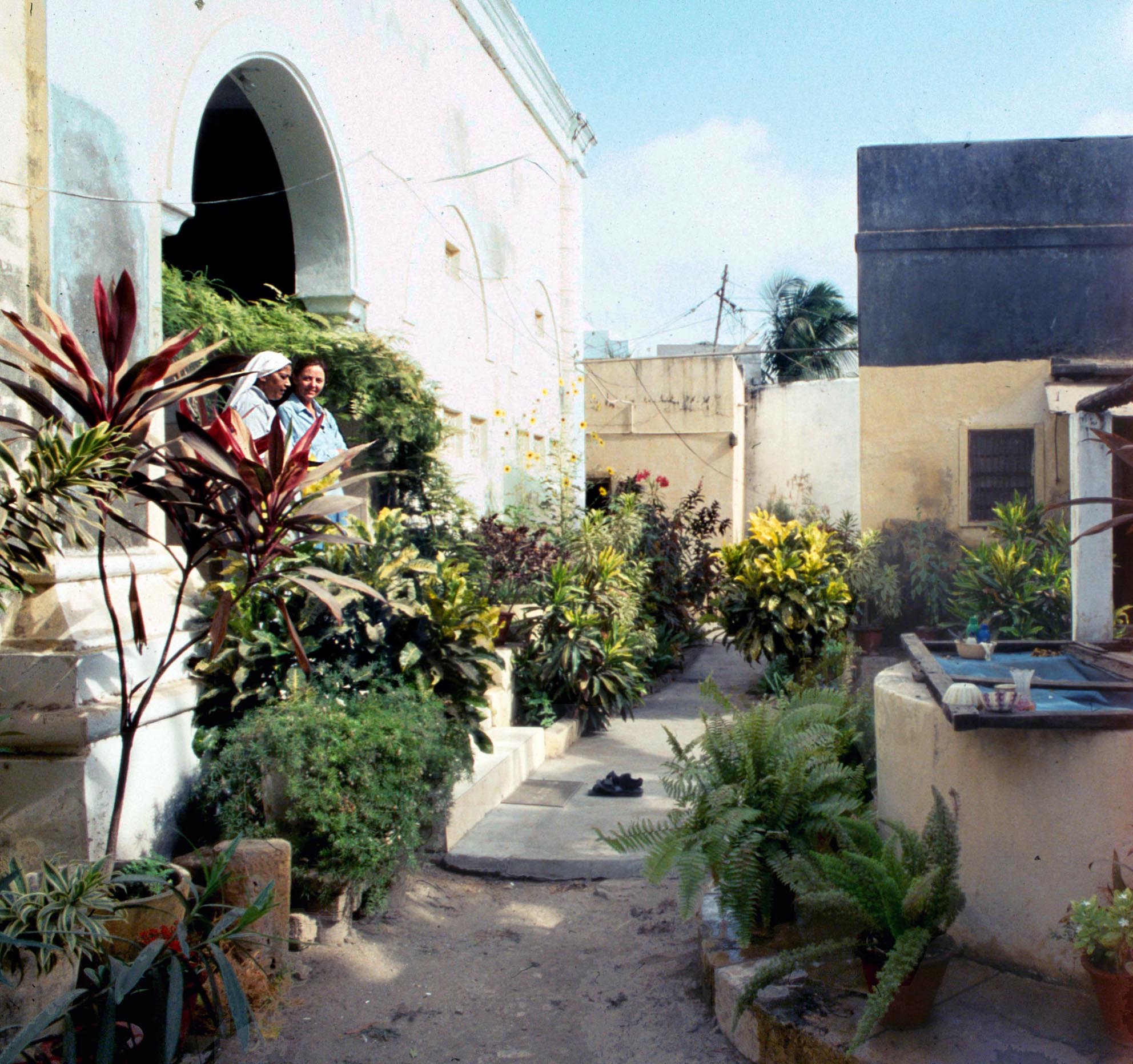 In Diu the Parsis occupied a small quarter to the north of the town near the harbour, between the Christian quarter and the commercial and administrative core. Although the community left the island over half a century ago the grandness of their former residences attest to its affluence. The houses, some now subdivided and in multiple occupation, are in the European style, mostly in the Iberian colonial tradition with arched windows, doors and porticoes but some are in a neo-classical idiom with a local version of Greco-Roman columns. Central to the former Parsi quarter is the fire temple set in a garden with high walls, preventing the building from being seen from the outside, and outside the town are their two funerary Towers of Silence (dakhma), which have survived, remarkably, as it is customary for Zoroastrians to destroy their dakhmas when they are no longer in use. These features are studied fully in The Zoroastrian Towers of Silence in the ex-Portuguese colony of Diu BAI, vol. XXI and for the Fire Temple see The Zoroastrian fire temple in the ex-Portuguese colony of Diu, India, JRAS, XIII, 2003.
One of the Handmaids of Christ and Natalie Shokoohy on the veranda of the fire temple, now converted without alteration to a convent and school, On the right is the well, an integral component of a fire temple, the unpolluted water of which is used in worship and ceremonies. The well still provides clear and refreshing water for the convent.
* The mosques of Bayana, Rajasthan, and the emergence of a prototype for the mosques of the Mughals, M. and N. H. Shokoohy, The Medieval History Journal, vol. XIII, part ii, 2010, 153-197, figs. 1-20.
ISSN: 0971-9458
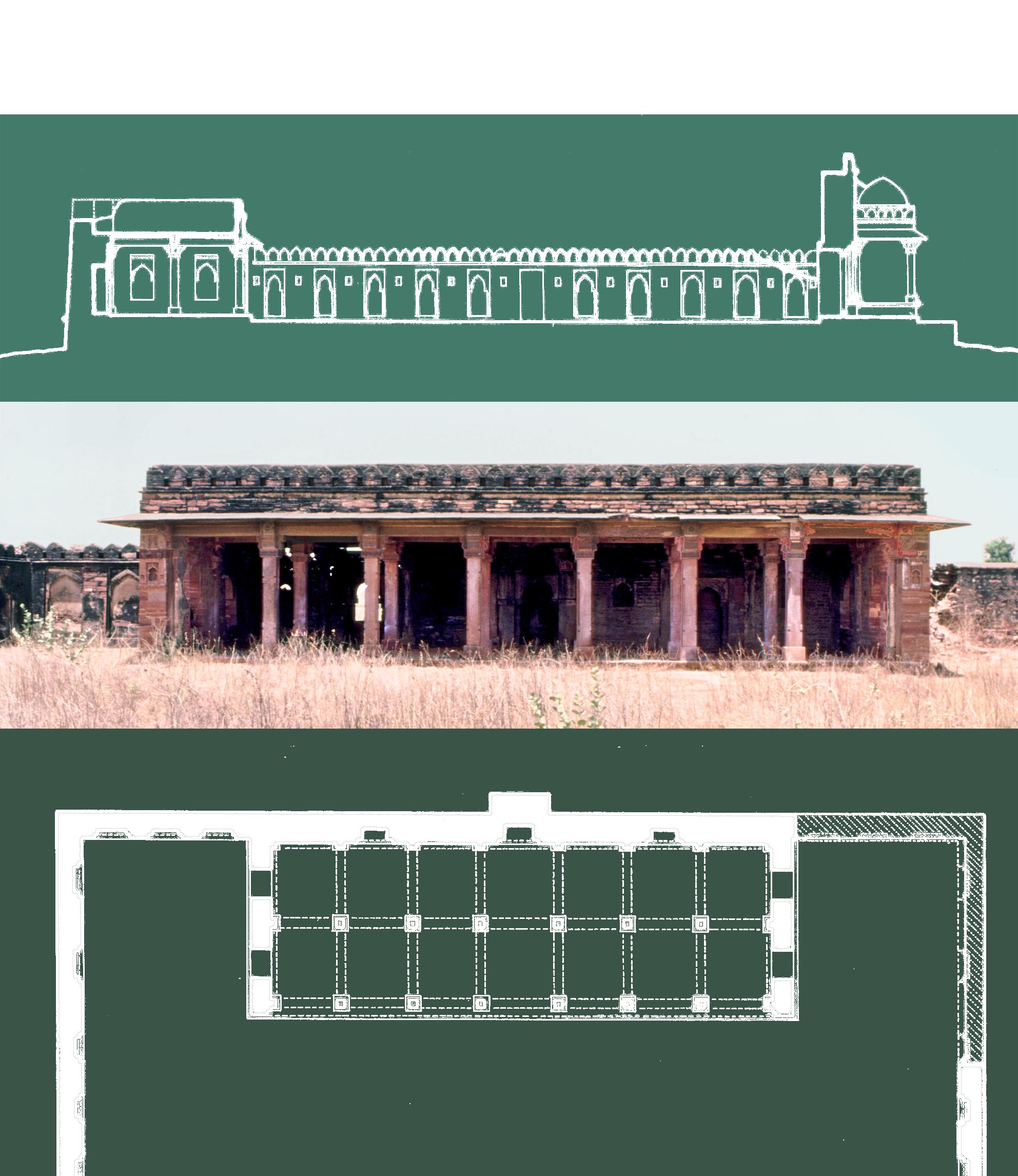 The sixteenth century or earlier ʽIdgah Masjid at Barambad,
one of four surviving mosques with a plan devised in the
Bayana region, featuring the prayer hall jutting out into the
courtyard.
At the time of the sultanate of Delhi Bayanas political autonomy is reflected in its architectural monuments, particularly the mosques. A comprehensive survey of all surviving mosques of Bayana from the thirteenth century to the Mughal period is presented (except the Ukha Mandir Masjid built by Muhammad b. Sams governor Baha al-din Tughrul, and its extension the Ukha Masjid built a century later, for which see: The Architecture of Baha al-din Tughrul in the region of Bayana, Rajasthan), together with detailed descriptions, measured drawings and photographs. The edifices include the Jami` of Sikandra (in Bayana, not to be confused with Sikandra near Agra), Muftiyun ki Masjid, Talakini Masjid, the Auhadi Jami` and its minaret in the fort, Taleti Masjid in the fort, `Idgah Masjid at the nearby village of Barambad, and two Lodi mosques in Sikandra.
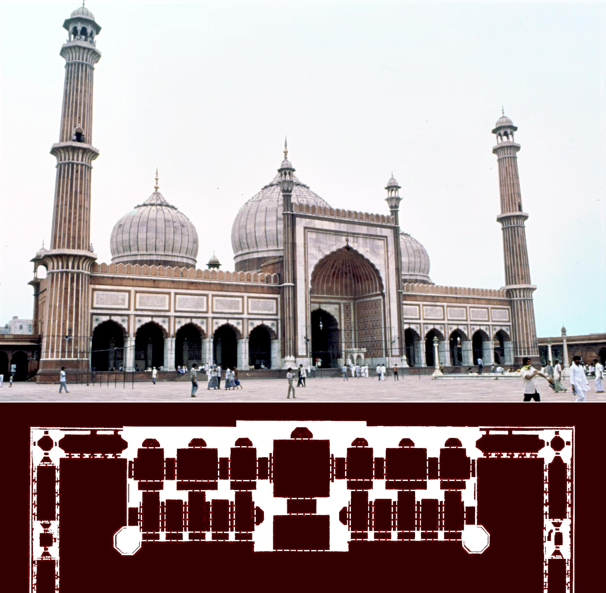 Although Bayana is only about 200 km (125 miles) from Delhi its architecture does not conform to that of the mighty sultanate and invents and re-invents its own local style. When in the fourteenth and fifteenth centuries arcuate forms imported from Khurasan (present Afghanistan, Uzbekistan, Turkmanistan and the Khurasan province of Iran) flourished in Delhi, the Bayana architects, although aware of these structural advances, continued to choose the ancient Indian trabeated system, not as a result of lack of innovation, but as a display of their autonomy. Their design development led instead to a new concept for mosque plans, in the late fifteenth to sixteenth centuries, where the prayer hall no longer filled the western side, but jutted out into the courtyard, so that the northern and southern walls of the mosque stood within its courtyard. Akbar who had his capitals at Agra and Fathpur Sikri, once two villages in the Bayana territory, also adopted features of the architecture of the region. The new mosque plan first appears to some extent in the Shaikh Salim Chishti mosque, but the fully-fledged plan becomes a feature of later Mughal mosques of the time of Shah Jahan and his successors.
The Jamiʽ Masjid of Delhi built by the seventeenth Mughal emperor Shah Jahan. Although built with arches and domes rather than beams and brackets, the composition of its plan is closely similar to the mosques of Bayana.
* The Zoroastrian Towers of Silence in the ex-Portuguese colony of Diu, M. Shokoohy, BAI, vol. XXI, 2012, 61-78, figs 1-20 (4 old engravings, 2 site plans, 5 architectural drawings, 11 photographs).
ISSN: 0890-4464
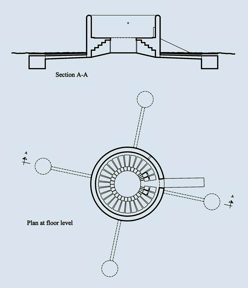 From ancient times Zoroastrian funeral practices have attracted the attention of outsiders, as rather than being cremated or buried the body of the deceased is exposed to birds of prey in a dakhma, a structure known in the West as a Tower of Silence. Many such towers still stand in Iran and India, but in spite of extensive discussion on Zoroastrian beliefs, rites and rituals regarding disposal of the dead, study of the physical and architectural features of such towers has remained minimal, as approaching let alone entering a dakhma is forbidden to all, including Zoroastrians, apart from the corpse bearers. The available information on the interior of these towers has so far been based on some architectural drawings apparently prepared for the construction of the dakhmas in Navsari and Bombay of a large dakhma, published in 1892. Although it is well known that dakhmas can vary in size and interior arrangement these widely reproduced drawings have created a predetermined concept of a standard form.
Plan and section of one of the two dakhmas of Diu, which has survived intact, providing material evidence on the form and function of these Towers of Silence, which are otherwise inaccessible to the public or even Zoroastrian priests.
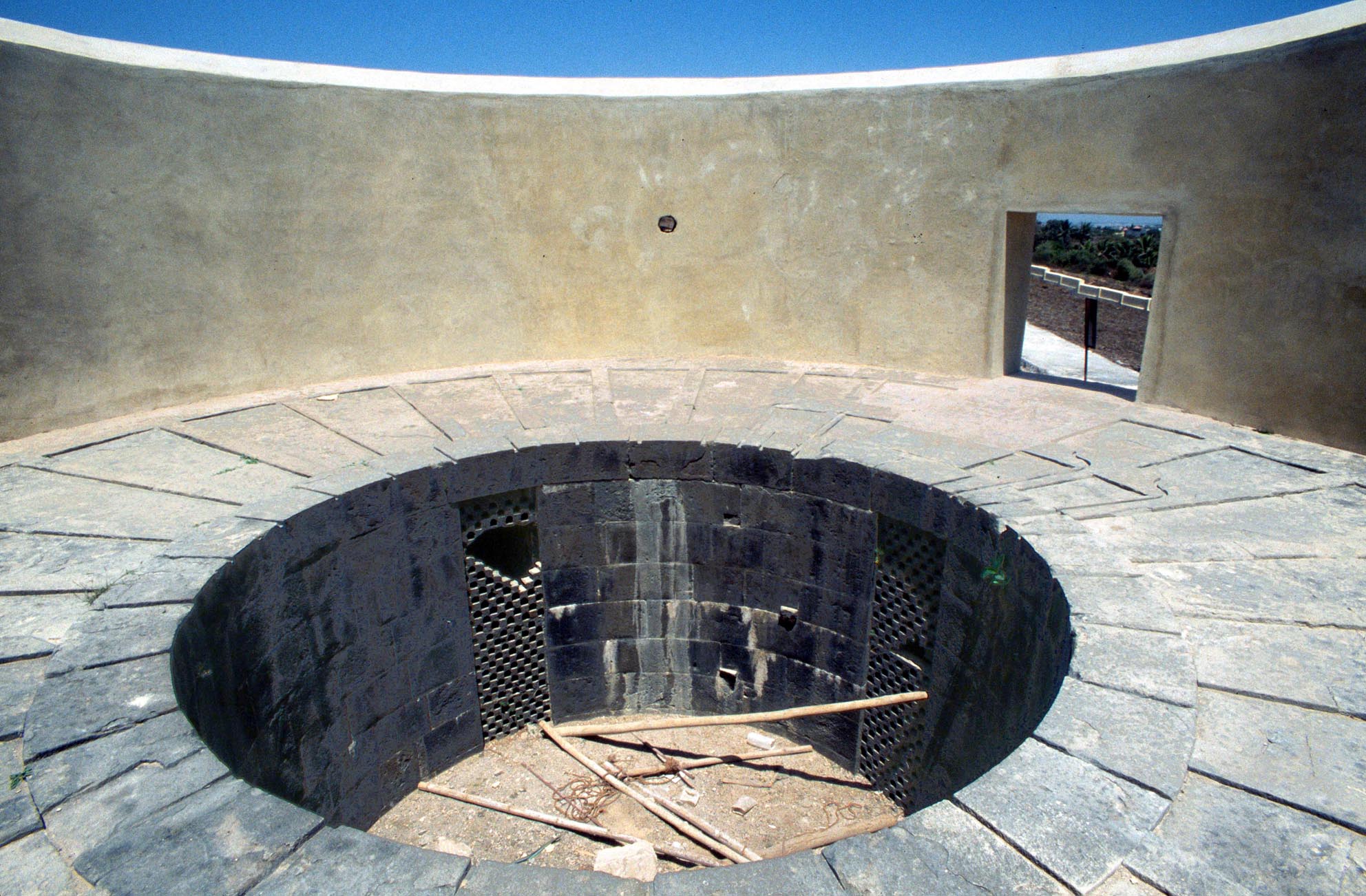
Interior of the dakhma showing the entrance, the receptacles,
and the central shaft which functions both as a drain and as
an ossuary. The small aperture in the wall gives a view to the
prayer hall or sagri.
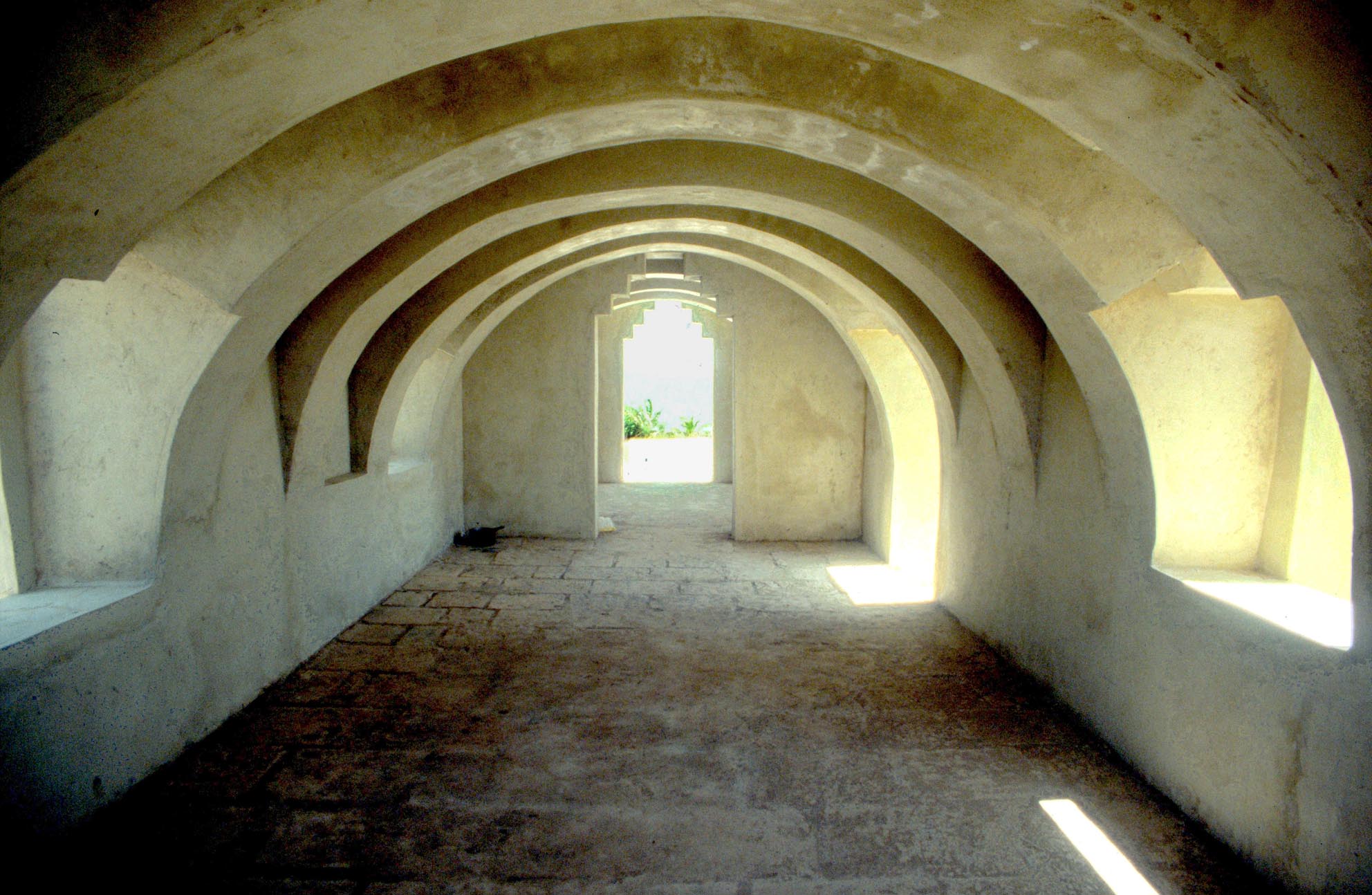
The sagri is a hall or enclosure where the mourners gather for prayer. It does not have any specific form and is usually built in the local traditional manner. The sagri of Diu is a long narrow structure with the style of its arches and vaults borrowed from colonial Portuguese architecture.
A dakhma is traditionally destroyed when no longer in function, but the preservation of one of these towers in Diu has provided an unprecedented opportunity to investigate such features in depth. The Diu tower clarifies many aspects of the development of the form in the last two centuries. It is a unique example of a fairly small tower, the design of which is very different from what has been widely perceived as the norm. In spite of the tradition of demolition, there are still some extant old dakhmas in India and Iran, leaving the field open for future investigation, which would no doubt expand our still limited knowledge of the variety of design within a set formula for the traditional Zoroastrian system of disposition of the dead, a custom already abandoned in Iran and not practiced by Zoroastrian communities in the West. Only in India the tradition still continues, but even there it is gradually dying away and dakhmas may soon become part of history.
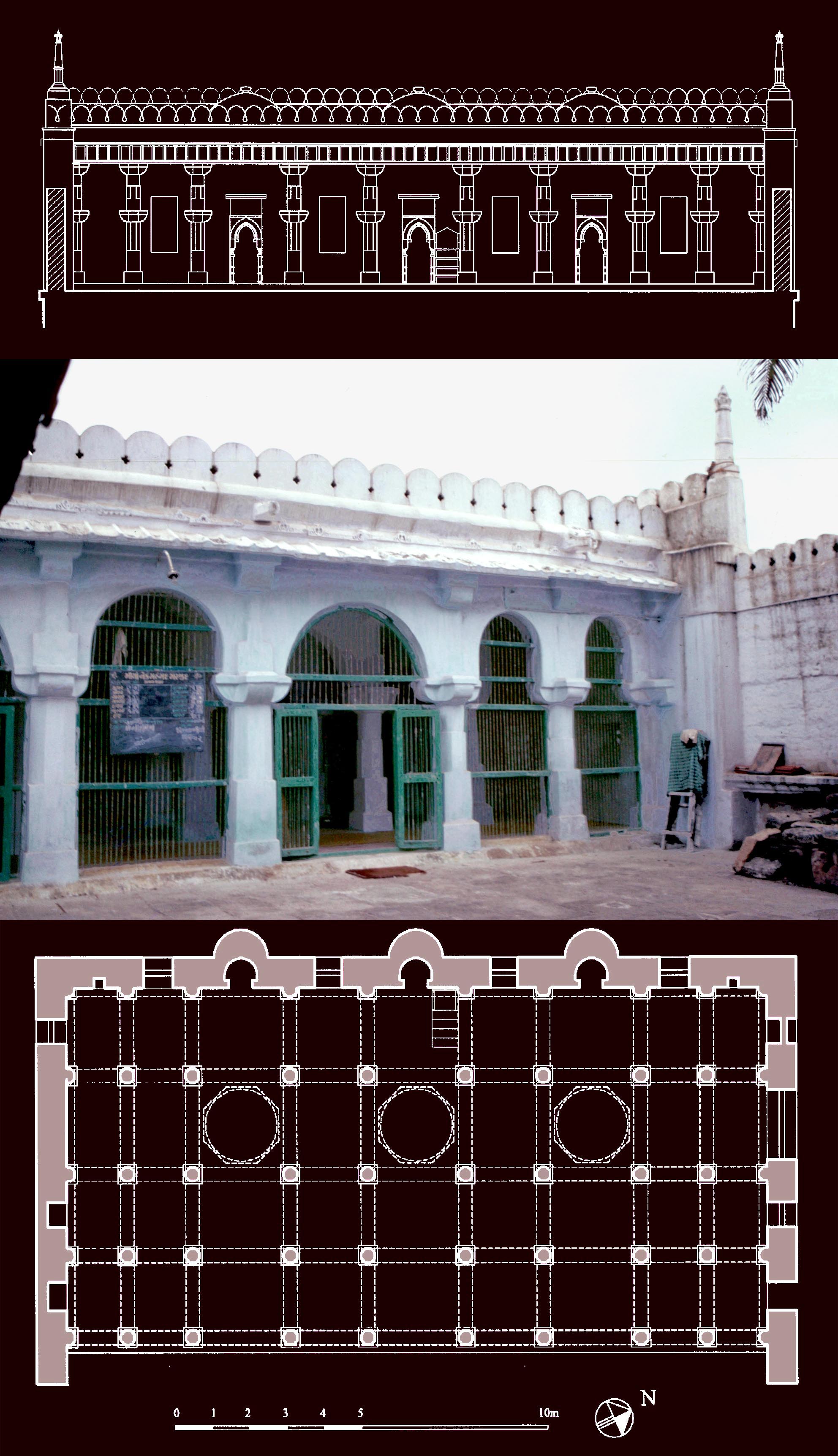 * The legacy of Islam in Somnath, M. Shokoohy, BSOAS, vol. 75 part 2, 2012, 297-335, figs 1-27 (1 town plan, 20 architectural drawings, 26 photographs).
ISSN: 0041-977X
EISSN: 1474-0699
Since the sack of Somnath by Mahmud of Ghazna in AD 1025-6, Somnath has been a byword for religious orthodoxy, intolerance and conflict between Muslims and Hindus. Yet looking further than Mahmuds greed for the temples' gold and later the Delhi sultans appetite for territory, Somnath and most other towns of Saurashtra had long-established settlements of Muslims engaged in international maritime trade. The settlers, while adhering to their own values, respected their hosts and their traditions and enjoyed the support of the local rajas. It is only in recent years that Hindu nationalist parties have revived the story of Mahmud to evoke resentment against the era of Muslim domination, with the aim of inducing communal tensions and gaining political power.
The Chaugan Masjid is one of the two major mosques of Somnath which date from the early to mid-fourteenth century and are apparently older than the large but less elaborate congregational mosque of Somnath.
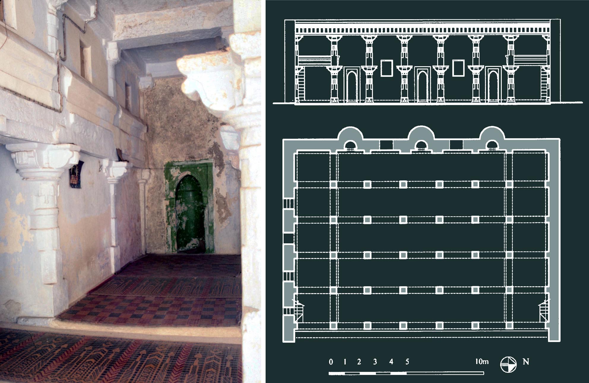
The Idris Masjid, the other fourteenth century
mosque, which has two unusual upper galleries
running the length of the side walls of the prayer
hall. The galleries are now walled up and used
as storage, but were originally open to the prayer
hall with parapets, still preserved, leaning slightly
outward.
The inscriptions and many mosques and Muslim shrines in this Hindu holy city and its vicinity are witness to the long history of harmonious co-existence between Hindus and Muslims. The paper explores the Muslim culture of Somnath by studying its major mosques. Through an analytic exploration of the typology of the mosques of Saurashtra, the paper demonstrates that, while the old centres of power in Gujarat lay outside Saurashtra, it is in Somnath and its neighbouring towns that numerous mosques dating prior to the sultanate of Gujarat still stand. These monuments help illuminate our understanding of early Muslim architecture in Gujarat and its aesthetic evolution from the time of the peaceful maritime settlements to the establishment of the Gujarat Sultanate.
* Kashmir V, Persian Influence on Kashmiri Art M. Shokoohy, EIr, vol. XVI, fascicle i, May 2012, 61-4, 2 photographs.
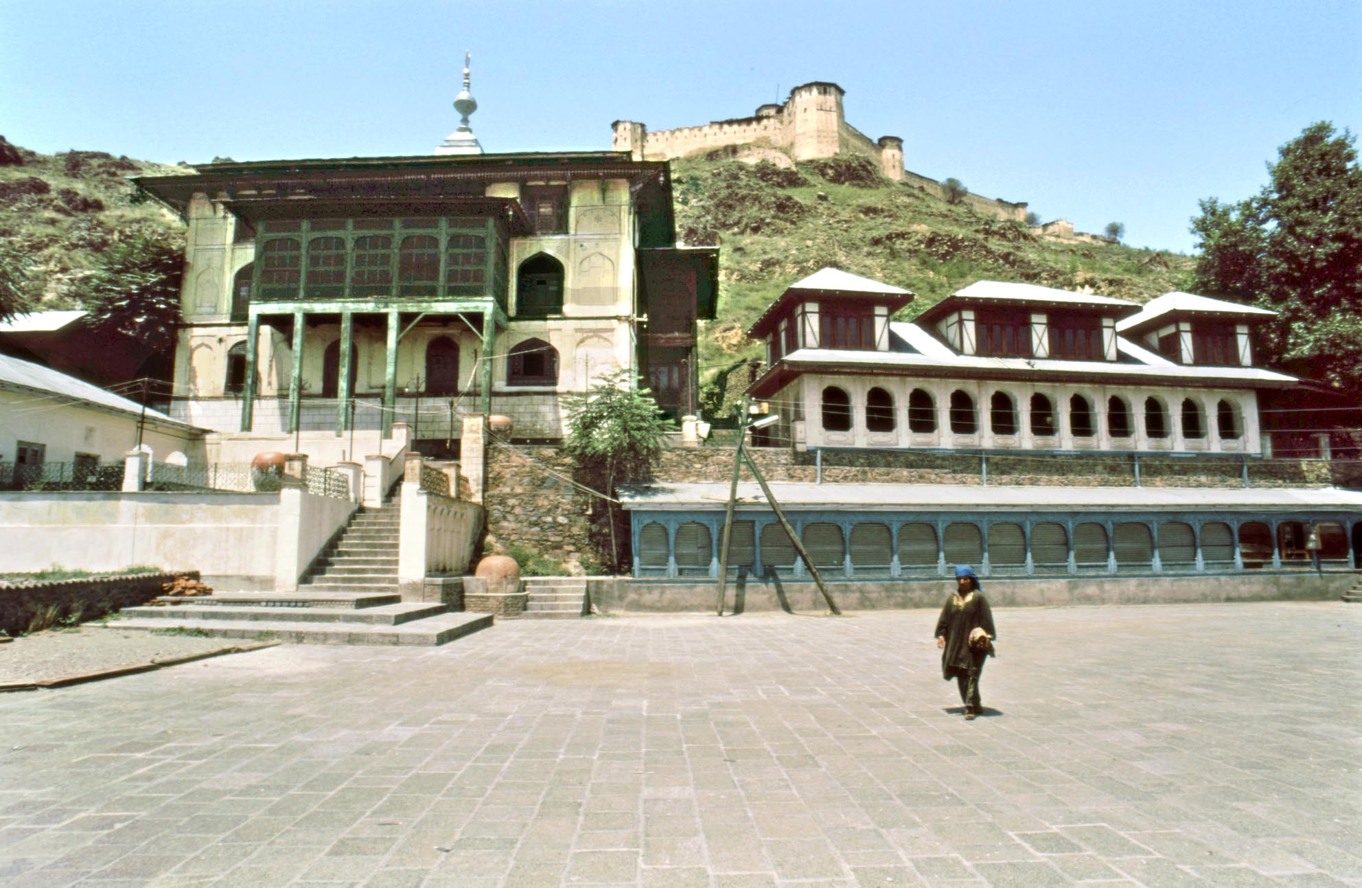 A concise and comprehensive account of the history of art and architecture of Kashmir from early days to modern times. The earliest Iranian influence appears in a fragment of a second-century statue of a Kushan ruler, carved in the Parthian style, and further and more extensive Iranian influences on Kashmir are seen after the disintegration of the Parthian Empire in 227. As the Sasanian expansion eastward did not extend as far as Kashmir, the Parthian style continued to flourish in the Buddhist sites of the region. Even Indian costumes are represented in a non-Indian manner, but the images illustrate that Indian elements were also present in the region. Later Buddhism, along with its art, was replaced by Hinduism and the Iranian influence would not be seen in Kashmir until the mid-fourteenth century.
The shrine of Makhdum Husain at Srinagar. The fort above was built by the Mughal Emperor Akbar and later restored by his successors.
Islam was introduced to Kashmir by one Shah Mirza or Shah Mir, a Muslim adventurer in the court of the local raja in AH 715/AD 1315-16. Shah Mir subsequently married the last Hindu ruler, a Queen, but killed her a day after their marriage. The spread of Islam was slow but firm and eventually Sultan Sikandar b. Hindal (r. AD 1393-1417) converted the entire population. Little remains of the edifices, but from what is preserved it appears that they were often made entirely of timber or with brick or stone walls and Islamic arches, but with a timber pitched roof surmounted by a square canopy with a further elongated pitched roof similar in form to the pinnacle of a Himalayan stupa and used as a minaret for the call to prayer. An exception is the tomb of Sultan Zayn-al-ʽAbidins mother: a brick structure consisting of an octagonal domed chamber with four smaller domes over three square chambers and the entrances. The building seems to have been inspired by the grand monuments of Samarqand, but executed on a modest scale. An outstanding monument is the Jami Mosque of Srinagar, which has an Iranian and Central Asian four-iwan plan built with brick walls and grand arches for the iwans, but with wooden columns supporting a traditional Kashmiri-style timber superstructure. In his memoirs, the Mughal emperor Jahangir describes that that the roof of the mosque, as with those of other buildings, was covered with soil and planted with tulips. The mosque was later rebuilt at the end of the reign of Jahangir (r. 1605-27) but apparently without much alteration to its original layout and appearance.
The paper also discusses the famous Mughal gardens of Kashmir and the Akbars fort in Srinagar, completed by Jahangir, as well as other traditional arts of the region, particularly carpet weaving and the Kashmir shawls renowned for their elegance worldwide.
"BHADRESHWAR", M. SHOKOOHY, ENCYCLOPAEDIA OF ISLAM, 3RD ED. VOL 13, PART 4, 2015, PP. 57-8.
The entry in this new edition of the Encyclopaedia of Islam is a concise account of the history and architectural remains of the site which has preserved the earliest Muslim monuments in India. Bhadreshvar (Sanskrit Bhadreśvar), a village on the Gulf of Kutch (Kachh), Gujarat, is the site of the ancient fortified town of Bhadravati, and was from 741 AD under the protection of the Chaulukyans and governed intermittently by a council of Jain merchants. It is probably the same as Subara recorded by Al-Isṭakhri and the Ḥudud al-ʽAlam as an Indian port with a Muslim community. The town was attacked by Maḥmud of Ghazna on his return from the Somnath campaign, but two Sanskrit sources record the presence of an Ismaʽīlī community who built a mosque there in a date corresponding with1166 AD from their own funds but with the permission of the leader of the Jain council, apparently during the reconstruction of the town after Maḥmūds attack.
Amongst the surviving monuments are two mosques, the larger probably the same as that built in 1166 and the smaller apparently related to the nearby Shrine of Ibrahim, (also known as the dargah of Laʽl Shahbaz) dated AH 554/1159-60 AD, half a century earlier than the Muslim conquest of India. In Bhadreshwar a number of tombs and sarcophagi dating between the mid-twelfth and early thirteenth century are found around the shrine and the main mosque. The stepped pyramidal form of these tombs is associated with the early maritime settlers and can also be seen in the island of Diu, off the coast of Gujarat. The architectural patterns and structural techniques of the local temples are employed in the Muslim buildings but only when the decorative motifs conform to Muslim traditions. A characteristic of these buildings is a portico on the eastern façade. Such porticos, not seen in Muslim buildings in Indias inland, feature in those of the maritime Muslim traders of the Indian littoral, appearing in Gujarat and as far away as Calicut and Cochin in Kerala and Kayalpatnam in Tamil Nadu.
"HISAR-I FIRUZA" M. AND N. H. SHOKOOHY, EI3, 2016, PP. 95-8.
A brief, but comprehensive encyclopedic entry on Hisar-i Firuza. Hisar, Haryana, India, funded by Fīrūz Shah Tughluq in 757/1356 and built in two and a half years, transforming a strategically important point in the desert on the route from Delhi to Khurasan to a thriving verdant town and region watered by canals from the Jumna and Sutlej rivers. Historic remains include Fīrūz Shahs fortifications, palace, royal mosque, the Gujari Mahal pavilion in a garden and Jahaz Kothi (a mosque surrounded by water). The town also preserves later mosques, tombs of Muslim saints and a series of mausolea commemorating Humāyūns soldiers who fought with him in Gujarat in 941-3/1534-6.
"BAYANA", M. AND N. H. SHOKOOHY, EI3, 2017, PP. 47.52.
Historic Bayana in Rajasthan, India, consisted of three towns: Bayana on the plain, the Fort of Tahangar or Viajayamandargarh six kilometres to its west, and Sikandra, Sikandar Lodis unfinished garden city. Bayanas strategic position on the route from Delhi to Gwalior and its formidable fort as well as its natural and agricultural resources a prized possession of its mediaeval Hindu rulers attracted the Muslim conquerors and at the end of the twelfth century the region was taken by the army commander of Muḥammad b. Sam, Baha al-din Tughrul, who was given the governorship of the region. Dissatisfied with the Hindu town in the Fort he built a town on the plain, called Sultankut, but soon to become known as Bayana, the name of the region. Two substantial monuments of Bahaʾ al-din still stand in the town, the congregational mosque (the Jamiʿ) now known as Ukha Mandir and an open prayer-ground (ʿidgah), the oldest example in India. The mosque is a colonnaded structure built with temple spoil built around a courtyard on an Arab-type plan and the ʿidgah, outside the town, is a prayer wall in the style of an early Iranian namazgah or muṣalla, but differs considerably from later specimens in India. Two of Bayanas finest monuments date from the time of Mubarak Shah Khalji (AH 716-20/1316-20), one is a reservoir, the Jhalar Baʾoli, and the other is the Ukha Masjid, an extension, dated AH 720/1320-1 to the Ukha Mandir mosque.
With Timurs invasion in 1398) and the fragmentation of the Delhi sultanate, the Auhadis the local rulers of Bayana asserted their autonomy and remained in power for two centuries. During their reign Bayanas architecture, applying old trabeated (beam and bracket) structural forms, flourished independently from the rest of India and created diverse forms distinctive to the region. A mosque known as the Taleti Mosque, dated AH 823/1420 has its prayer hall protruding into the courtyard, a complete departure from the usual Indian mosque plan, and first seen in the Bayana region. This formula is repeated in at least three other mosques of the time of Lodi dominance, including the ʿIdgah Masjid in the nearby village of Barambad, closely comparable in scale. This spatial arrangement was to become characteristic of the Mughal period.
Sikandar Lodi (AH 894-923/1489-1517) finally put an end to the regions autonomy and decided to make Bayana his new capital, with a new city named Sikandra but he later decided that Agra, then a village of Bayana, would be more suitable for his capital and Sikandra was left unfinished. Nevertheless, a grand mosque in the Delhi style, a number of structures in the gardens outside the town and a multi-storied step-well, built of red sandstone by threee unfinished prototype of Sikandra.Sikandars governor Khan-i Khanan Farmuli in the Fort, remain from this period. This step-well is in all details a forerunner of Akbars buildings in Fathpur Sikri. An earthquake devastated Bayana in 1505 and the Fort was virtually abandoned, while most of the population migrated to Agra, but Bayanas political and cultural influence was not extinguished and during the reign of Islam Shah Sur (1545-1554) one Shaikh ʿAlaʾi claimed to be the Mahdi (an absent saviour imam who will rejuvenate Islam) causing religious and social upheaval.
Bayana remained as a regional centre under the Mughals and at the time of Humayun, his army pay-master, Muḥammad Bakhshi, built in the Fort a fine multi-storied pavilion which is the first fully-fledged building in the Mughal style, and an antecedent of the Hawa Mahal at Fathpur Sikri. Other Mughal monuments in Bayana town are Kali Khans tomb and the Jhajiri, a red sandstone tomb with walls of pierced stone-work, and in the nearby village of Barambad the gate and step-well of the garden of Maryam Zamani, mother of the Emperor Jahangir built in AH 1022/1613-14. Modern Bayana, after a period of decline during the last two centuries is again emerging as a centre for the production of red sandstone which is exported all over India.
The Lady of Gold: Sikandar Lodi's mother (c. 837/1433 - 922/1516)
and the tomb attributed to her at Dholpur, Rajasthan,
M. and N. H. Shokoohy, BSOAS, vol. 81, Part 1, 2018

It is said that in the days that Bahlul Khan was Governor of that town (Sirhind or Sihrind) he had built outside the fort a mansion comparable to the heavenly paradise. Sometimes he resided there. In those vicinities lived a goldsmith who had a daughter with a face like a tulip and hair the colour of musk; it happened that Bahluls eye fell upon her, he was enchanted. That beauty with moon-like face also gave her heart to him. When he sat on the royal throne he satisfied the wishes of her father and married her. This was Sikandar Lodis mother as described by the Tarikh-i Shahi.
Until the Mughal period historians of Muslim India hardly mention ladies, as it was considered discourteous, while in any case only a handful of noble women were deemed worthy of mention. A secluded lady was of concern only to the man of the house. But a few womens influence reached beyond the harem and their voices appear between the lines. One was Sultan Raḍiya, Īltutmishs daughter, who succeeded to the throne and enjoyed a degree of freedom during Turkish rule in India, but was killed, accused of an illicit relationship with a black slave. Another was the Sharqī Sultan Muḥammads mother, Bībī Rājī, who played a significant role in the affairs of Jaunpur, but this article concerns Sultan Sikandar Lodīs mother, known as Bībī Zarrīna the Lady of Gold, who defied the Lodī nobility to put her son on the throne. Here we explore her story and study her tomb.
 The handsome and elaborate tomb of Bībī Zarrīna faces a mosque, both built of red sandstone with the trabeated structure typical of the Bayana region. Unlike the Sayyid and Lodī buildings of Delhi, deriving from Tughluq architecture and often incorporating arcuate structures set on monolithic columns, in the Bayana region all major Lodī buildings are trabeate. A unifying design for the complex is expressed in the beam and bracket structure of the mosque and the tomb, but there are subtle differences in detail. The columns of the tomb are plain, but on the exterior between the columns pierced stone screens carved with a variety of interlaced patterns give a particular charm to the interior when patterns of light and shade fall on the floor and the tomb.
The contrast between the delicate tomb and the more massive and plain mosque leads the eye from one feature to another. The modest scale of the compound also seems intentional, as it suits the mother of a king, leaving a grander design for the tomb of the sultan himself, buried in Delhi. But there may have been another reason for the chosen scale. If the mausoleum were much larger it could not have been as light as it is and the balance between the size of the building and the finely carved screen work would have been lost. As it is, the chamber with its fine open work echoes the form of an ornamental jewel box; a suitable form, perhaps, for the daughter of a goldsmith, and within it the jewel the mortal remains of the Lady of Gold.
"Kayalpatnam: history and architecture", EI3, 2018, pp. 135143, illustrations 1-3
Kayalpatnam (the City of Kayal, Tamil Nadu, India) is renowned in the history of the Indian Ocean maritime trade and is still inhabited by Muslims of Middle Eastern origin. The town is the site of the port of Qail and was visited by Marco Polo in c. 1293 who called it Cail, noting that ships from the islands of Hurmuz and Kish in the Persian Gulf, laden with horses and from Aden and Arabia, anchored there with other merchandise for sale. The town was a major port of the Coromandel Coast known to the Muslims as Ma`bar (the pass) and from the thirteenth century the commerce of the region was in Muslim hands, with its governor one Malik Taqi al-din al-Tayyibi, a relative of the rulers of South Iran and a minister of the Hindu ruler of Ma`bar. In this port Chinese merchandise was exchanged with goods from the Middle East and even Europe. The local products, particularly pearls, fine red silk and aromatic roots were exported, but the main import was horses, over 11,000 a year sold to the kingdoms of South India.
Although Ma`bar was taken by the army of the Delhi Sultans `Ala al-din Khalji in 1310-11 whose rule was followed by a short-lived sultanate which probably included Qail in its jurisdiction, the merchant community of the town remained aloof from politics and maintained its international trade, exporting local products, particularly gemstones and pearls which were gradually replacing the import of horses. The fame of the pearl fisheries lured first the Portuguese and later the Dutch who depleted the oyster beds ending the fame of Kayalpatnam. Today Kayalpatnam is a small but expanding and prosperous town with its Muslim population living in harmony with their Hindu and Christian neighbours.

Kayalpatnam, Jami` al-Saghir or Khutba Sirupalli, the oldest mosque in the town, dating back probably to the thirteenth century. Interior and plan which also shows a tomb chamber attached to the mosque. Among the seven early fifteenth-century tombs in the chamber one dates from 806/1403. In the plan recent additions on either side of the tomb chamber are given with lighter lines.
The town has preserved a large number of historic edifices mainly constructed of ashlar, with flat stone roof slabs, some echoing the timber roof structures which were once abundant in the region, but now rare. The mosques follow the Arab tradition of having a single prayer niche (mihrab) rather than the multiple mihrabs seen in North India. Vaults and arches, common elsewhere, are not employed, instead, a covered colonnaded prayer hall with a porch is the norm. The oldest buildings are the two congregational mosques (Jami`) known as the Khutba Parriapalli or the Jami` al-Kabir (the greater Jami`) dated 737/1336-7 and the Khutba Śirupalli or the Jami` al-Saghir (the smaller Jami`). Both share a similar plan, with plain and bold structural details. Other smaller mosques have a similar layout and structural features, comprising a prayer hall with a colonnaded entrance porch at the east.
Certain new concepts of design were introduced in the seventeenth-century, best manifested in the Rettaikulampalli, a mosque which while it preserves the colonnade principle, accomplishes a wider central nave by means of elaborate multiple brackets supporting flat roof slabs of the maximum length permitted by the properties of the stone. Domes only appear in the nineteenth century, one added in the centre of the Jami` al-Kabir and another over the circular Mahlara mosque built in 1288/1871 in the Qadiriya Madrasa. Three old tomb chambers preserved in the town also display the form of the earlier widespread timber buildings. They are rectangular in plan, and while constructed entirely of stone, have hipped roofs imitating the timber roofs still characteristic of Kerala.
"Kozhikode (Calicut), history, art and architecture", EI3, Part 1, 2019, pp. 132138, illustrations 1-3.
Kozhikode, better known as Calicut (Kerala, India) is known in history for its old established and resilient Muslim community whose alliance with the regions powerful Hindu Rajas (Zamorin of the Portuguese and Samiri of the Muslims) left commerce firmly in the hands of the Arabs and the Persians, as described by many travellers such Ibn Battuta in the 14th century, Nicolò de Conti in the early 15th, and `Abd al-Razzaq in the mid-15th century who mentioned that the Muslims were mainly Shafa`i and had two congregational mosques (Jami`), an unusual tradition still current. Calicuts commercial fame attracted the Portuguese who challenged Muslim dominance, and created a long period of hostility between the two.
 At first, in 1498, the Muslims blocked Vasco da Gamas attempts at setting up a trading post and two years later, in his second voyage, when negotiations failed the Portuguese shelled the town, burned the houses and the main congregational mosque, but were at the end defeated ‒ with the mosque being rebuilt even grander than before. However, with the growing marine supremacy of the Portuguese armada many Arabs and Persians gradually left the scene, and the Muslim global trade, based on peaceful free enterprise, came to a virtual end. In the course of time the Muslims, now many of local origin, remained strong, rebuilt their edifices and today live in many parts of the region as well as in the core of the old port, making up almost half of the population of Calicut.
Calicut, the fourteenth century Mithqalpalli, with the timber upper
structure of the mosque reconstructed in the sixteenth century.
The two lower tiers follow traditional structural principles, but the
two upper tiers are set back successively to create the imposing
four-tiered appearance of the mosque, which is the most impres-
sive of all Muslim structures in Malabar.
The old Muslim quarter, known as Kuttichira, at the south-east of the modern town, occupies an area surrounding the historic tank and town square, still a gathering-place. To its north-east stands the imposing Mithqalpalli, the congregational mosque constructed originally in the 14th century by Nakhuda Mithqal, a wealthy ship-owner and merchant. This is the mosque that the Portuguese burned in 1510 and was reconstructed in c. 1578-9. The prayer hall and ante-chamber are at ground level, constructed with stone walls with arched doors all around, and surmounted by a grand timber roof in four tiers housing three upper floors supported by a combination of stone walls and wooden columns. At the northern side of the ante-chamber, a chamber housing an ablution chamber has been added later.
 In the Mithqalpalli the single prayer niche (mihrab) has a deep semi-circular plan and a semi-circular arched profile decorated with foliations jutting out of the frame at the sides and the crown, unfamiliar in Indian and Middle Eastern architecture, but similar to motifs seen in the 15th-century tombstones of Malaysia, indicating widespread links in maritime arts and architecture. The mosque has also retained its old wooden pulpit (minbar) bearing a number of Arabic inscriptions recording the dates of renovations, the earliest carried out in the first decades of the 17th century on the order of the Port-master, Jamal al-din `Antabi, apparently from Entebbe in Uganda.
The other congregational mosque in its present form is the largest mosque of Calicut, but was originally a much smaller building chosen as the Jami` after the burning of the Mithqalpalli, and enlarged later. The mosque and its minbar bear many inscriptions, the oldest, referring to an early restoration dating from 885/1480-81. Another records the addition of a porch in 1679-80 by a shipmaster, Shaikh `Imad who in 1683 also restored its elegant minbar. The mosque is entered via the porch, opening to an ante-chamber which in turn leads to a large prayer hall. The plan is not much different from that of the Mithqālpaḷḷi and other mosques of the town, but its proportions and asymmetrical layout the result of the extensions and alterations make it unlike other mosques of South India. A feature of the mosque are two rectangular pools inside the prayer hall, with openings in the roof to allow light for the hall and rainwater to pour into the basins, creating a pleasant cool interior environment, an architectural innovation with no ritual function.
Calicut, present plans of the two oldest mosques in the
town the Jami` (above) and Muchchandipalli (below).
The remains of the layout of the original walls are shown
in solid black and later additions in line drawing.
Near the mosque is another smaller mosque, the Muchchandipalli which is probably the oldest in Calicut, bearing a foundation inscription which seems to date from 1287-8. Another records its renovation in c. 1480-81. The structures stone walls have semi-circular arched doors similar to those at the Mithqalpalli. The decorated porch is close in form to that of the Jami` and from the same period. The wooden upper level is similar to that of the Jami` but has been partly reconstructed in later dates, giving the façade a three-tiered appearance. A number of smaller mosques in Kuttichira are all built on the same principle of stone walls with wooden columns and roof structure, and altogether Calicuts Muslim edifices represent the best of Keralas rapidly disappearing architectural traditions, with the Mithqalpalli, still the grandest mosque in South India.
Kochi (Cochin), history, art & architecture, EI3, Part 2, 2019, pp. 116-122, illustrations 1-4.

Cochin, the historic Jami` mosque also known as Chembattapalli, burnt to the ground by the Portuguese and rebuilt entirely in 1519-20.
Cochin, renamed Kochi (Kerala, India), well-known for its Jewish settlement, also has a rich Muslim heritage. The history of the town goes back only to after 1341 when a geological event re-shaped the coastline with old Cochin being submerged under water and the island of Vypin emerging from the sea, heralding a new era, Puduvaipu, used for dates in many records. The ancient town was an insignificant port, ignored by the early merchants and the Moroccan traveller Ibn Battuta, who passed the site of old Cochin early after its destruction but does not mention the present town, which was not yet established, although he visited the Jewish settlement above a hill apparently un-affected by the catastrophe.
 The new town developed probably by the end of the 14th century along the calm backwater which formed an excellent harbour and the town entered the geopolitics of the time when, in 1500, its Raja made an alliance with the Portuguese. At the time Cochin was still a small town with the Rajas palace, according to the Portuguese, a humble structure, badly furnished and the townspeople living in houses with mud walls and timber roofs. However, the Muslim merchants (the Moors) lived in grander dwellings enclosed by stone walls to protect their merchandise. The Jews and Muslims were under the Rajas protection and in spite of the Portuguese hostility to these communities they were obliged to tolerate them. The Muslim who were importers of rice (the staple diet of South India) retained their position and traded not just with the local people but also with the Portuguese, who nonetheless destroyed a mosque on the coast which was later rebuilt and still stands today.
With the decline of Portuguese maritime supremacy, the Dutch took over their fort, but in the power struggle with the Nawwabs of Maysor, first Haidar `Ali, and then his son Tippu Sultan, took control of Cochin and in 1789 even proposed to buy the fort, but the Dutch declined. Tippu's final defeat by the British also eliminated Dutch control and in 1796 they eventually transferred the fort to the British.
Cochin, below, Shrine of Zain al-din al-Ma`bari with
its mosque in the background photographed in 1994.
On the gable of the shrine the inscribed wooden panels
can be seen, but they have since been dismantled and
sold to private collectors. Above details of the inscription
in Malayalam and Tamil dated 1625.
From this time the Muslim population increased and while the Jews migrated to Israel the Muslim community has continued to flourish and has now spread out of their traditional neighbourhood to all parts of the town.
Architecture: In Cochin the old street layout of the Jewish and Muslim quarters has been preserved, with the Muslim institutions along the spinal Darussalam (dar al-salam) Road, including the shrine and mosque of Zain al-dīn, and the historic Shafi`i Jami`, also known as Chembattapalli, which is known for its wooden structure and details. The outer walls are of stone, but the columns and the entire two-tiered roof structure are of wood. The prayer hall is entered through a colonnaded entrance porch which bears a bilingual inscription of 1519-20 incorporating the phrase endure the fire alluding to its reconstruction after being apparently burnt by the Portuguese some two decades earlier. An old addition to the building is a chamber housing an ablution pool, but in recent decades the mosque has been extended extensively at the front of the porch. The original wooden upper structure is a large, well-ventilated, slightly dark hall with a high ceiling, once used as a madrasa (theological college). The buildings joinery is simple but the structural elements fit ingeniously together to support each other in equilibrium; a well-attested method, centuries old.
Near the mosque is a chamber housing the tombs of two local religious personages: Sayyid Isma`il and Sayyid Fakhr al-din Bukhari, and further away is the shrine and mosque of Zain al-dīn al-Ma`bari. These small buildings, while not as striking architecturally, are revered locally. The Shrine of Zain al-din had, until 1994, inscribed wooden panels on its gable (now dismantled and apparently sold to private collectors) in Arabic, Malayalam and Tamil text dated 1625 and another inscription dated 1591-2 over the interior of the entrance of the mosque which seems to refer to its construction. The shrine is also significant for being the tomb of the ancestor of the better-known Zain al-din, the author of the Tuhfat al-Mujahidin, the history of the Muslim maritime merchants struggles with the Portuguese.
Madurai, history, art and architecture, EI3, Part 2, 2019, pp. 138-146, illustrations 1-6.
Madurai a Hindu pilgrimage centre on the bank of River Vaigai, fell under Muslim rule following raids by the armies of the Khalji sultans of Delhi, `Ala al-din and Mubarak Shah followed by a short period of an independent sultanate (c. 1333 to 1378). The Moroccan traveller Ibn Battuta who visited Madurai records:
"Mathura is a large city, with broad streets. Sultan al-Sharif Jalal al-din Aḥsan Shāh
built the city to resemble Delhi
When I went to the city there was an outbreak of cholera ... The sultan
found his mother, his wife and child ill. He remained in the city for three days and then moved to the bank of the river situated one parasang from the town. At this place, there is a temple of the infidels."
_-c6278-01a,_DETAILS,_Tom_Turner_.jpg?240 "Madurai_Plan_in_BM_(OR_BL)_-c6278-01a,_DETAILS,_Tom_Turner_")
A mid-eighteenth century plan of Madura town and its immediate environ, As usual for many maps of this period the south (not the north) is orientated towards the top. The site of the Muslim quarter and the tombs of `Ala al-din and Shams al-din is shown at the bottom left.
He makes it clear that there were two Madurais: one Muslim (which could be under modern Tiruparangundram ‒ where the last Ma`bar sultan Sikandar Shah (c. 13721377-8) was slain by the forces of Vijayanagar), and the other Hindu ‒ by the River Vaigai with the great Sri Minaksi temple at its centre. The Hindu Madurai was, of course much older than Ahsan Shahs new capital but the burial in the earlier town of two of the Ma`bar sultans and some of their courtiers indicate it had a Muslim community, as does the historic mosque of Qadi Taj al-din. The Hindu layout follows the concept of the town as an image of the cosmos, with a concentric plan placing the Sri Minaksi Temple at its centre with two layers of perimeter walls. In spite of modern expansions, the old core is preserved along with the straight street layout of the town, generated around the temple with its four gates opening to the four main streets aligned in the cardinal directions.
Muslim architecture of Madurai
The Muslim architecture of Madurai shares similar structural principles with that of the Hindu monuments of Tamil Nadu, all constructed with dressed stone, but in their planning the mosques have a design peculiar to South India: a prayer hall, with or without an ante-chamber, fronted by a colonnaded portico. The foremost monument is the shrine housing the tombs of the Ma`bar sultans, `Alā al-din Udauji and Shams al-dīn `Adil Shah, consisting of a square domed chamber in the centre of a colonnade two aisles deep and covered with a flat roof. The design of the plan resembles that of many tombs of Gujarat and it seems likely that the form could have been introduced from Gujarat via the Indian Ocean trade route. The dome of the central square chamber with an inner diameter of 5.9 m. appears on the exterior as a simple hemispherical dome, but it is actually a single piece of rock smoothed on the outside but with the soffit only roughly hollowed out to demonstrate the monolith. There is no other parallel with this dome in Muslim buildings in South India, but in Hindu architecture carving huge monoliths and placing them on the top of temples was a common practice.

The mosque of Qadi Taj al-din, view of the eastern
entrance colonnade seen from the modern extended
hall. The lobed arches between the columns are later
additions. Above, line drawing of the east elevation
showing it in its original condition.
Among the mosques the oldest are one in the compound of the shrine of `Ala al-din and the other the mosque of Qadi Taj al-Dīn or Kazimar (Qadimar) in the town, both having the typical South Indian layout and without a formal courtyard. The Qadi Taj al-din mosque was extended in the 1970s as the congregational mosque (Jami`) obscuring the original core which is, however, preserved without alteration. It is believed locally that the mosque was founded by Taj al-din (d. 692/1292-3), but the present building seems to date from the Vijayanagar period. It consists of a colonnaded porch, opening via an ante-chamber to the prayer hall. The monolithic columns are elaborately decorated and their bracket-capitals follow the traditional Hindu and Muslim South Indian design. The single mihrab (prayer niche) is square in plan and has a slightly ogee three-lobed arch, which derives from a profile seen in numerous early mosques of both North and South India.
The ante-chamber leading to a prayer hall seen in this mosque and many others in South India never appears in North India. This layout may have been introduced from the coastal regions of the Middle East where such features could be seen in a ruinous 10th or 11th century mosque at Siraf, south Iran and in some 12th century mosques in the Yemen. If the shrine of `Ala al-din displays architectural influence from Gujarat, the appearance of ante-chambers in the mosques of Madurai and elsewhere in South India is material evidence of the cultural relationship of the region with Middle Eastern centres of maritime trade.